Report on Lokon-Empung (Indonesia) — May 2012
Bulletin of the Global Volcanism Network, vol. 37, no. 5 (May 2012)
Managing Editor: Richard Wunderman.
Lokon-Empung (Indonesia) Small plumes in 2012; activity increase in April-May
Please cite this report as:
Global Volcanism Program, 2012. Report on Lokon-Empung (Indonesia) (Wunderman, R., ed.). Bulletin of the Global Volcanism Network, 37:5. Smithsonian Institution. https://doi.org/10.5479/si.GVP.BGVN201205-266100
Lokon-Empung
Indonesia
1.358°N, 124.792°E; summit elev. 1580 m
All times are local (unless otherwise noted)
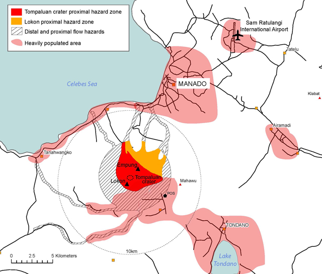
Our previous report on Lokon-Empung volcano noted activity to late-October 2011 (BGVN 36:11). The present report adds subsequent information through May 2012. Most of the following information was based on summaries of activity by the Center of Volcanology and Geological Hazard Mitigation (CVGHM; also known as Pusat Vulkanologi dan Mitigosi Bencana Geologi-PVMBG) and the Volcano Disaster Assistance Program (VDAP). A map of Indonesia showing the location of Lokon-Empung volcano is presented in figure 9, and figure 10 shows a hazard map of the area around the volcano.
 |
Figure 9. Map of Indonesia showing the location of Lokon-Empung volcano on the N tip of Sulawesi. Courtesy of CVGHM and VDAP. |
 |
Figure 10. A sketch map showing the location of Lokon-Empung volcano and various nearby hazard zones and populated areas. Courtesy of the CVGHM and VDAP. |
Following the 26 October 2011 explosion from Tompaluan crater (the most active vent, located in the saddle between the peaks of Lokon to the S, and Empung to the N; see fig 10) that sent incandescent blocks up to 800 m away from the crater (BGVN 36:11), a small eruption was reported on 7 November. The Alert Level remained at 3 (on a scale of 1-4) since 24 July 2011.
Three explosions from Tompaluan crater were recorded by CVGHM on 27 December 2011, along with 23 deep volcanic earthquakes and 40 shallow volcanic earthquakes. Explosions from the crater produced ash plumes on 9-12 and 21 February 2012 (figure 11).
Lokon-Empung's activity increased during 23 April 2012, when there were 180 volcanic earthquakes. On 24 April an eruption was accompanied by loud "thumping" noises heard at local observation posts, though fog prevented views of the crater. Satellite observations on 25 April showed ash and block deposits from this eruption scattered to the N and E of Tompaluan crater out to a distance of ~400 m from the crater rim.
The Darwin Volcanic Ash Advisory Centre (VAAC) reported on 1 May 2012 that ash plumes were detected in satellite imagery and reported by ground-based observers. The Jakarta Post reported that Lokon-Empung erupted on 2 May 2012 at 1155. This eruption was larger in magnitude than the one on 24-25 April 2012. The 2 May eruption was preceded by a number of mild earthquakes that occurred over a span of 2 min. A report noted that "smoke" plumes reached an altitude of 2.5 km. Table 10 gives a chronological listing of activity at Lokon-Empung from 1 November 2011 to 1 May 2012.
Table 10. Darwin VAAC plume observations at Lokon-Empung volcano for November 2011-2 May 2012 (with times in UTC). Note that meteorological clouds often obscured satellite observations. 'VA' denotes volcanic ash plume; '--' denotes data not reported. 'Remarks in VAAC reports' includes CVGHM observations typically made from the ground, as well as some media sources. Courtesy of Darwin VAAC, CVGHM, and VDAP.
| Observation Date | Time | Plume observations (altitude, drift distance, direction) | Remarks in VAAC reports |
| 27-28 Dec 2011 | -- | VA: 1.5 km | Low level eruption reported by media. |
| 29 Dec 2011 | 0415 | -- | VA reported by CVGHM, altitude 3.7 km. |
| 06 Jan 2012 | -- | -- | VA, altitude 1.5 km. |
| 09 Feb 2012 | 0020 | VA: 2 km | Explosion preceded by 16 hrs of increasing seismicity. |
| 10 Feb 2012 | 0145-0315 | -- | VA reported from ground, altitude 2.4-3.4 km. |
| 11 Feb 2012 | 0330 | -- | VA reported from ground, altitude 3 km, preceded by 16 hr of increasing seismicity. |
| 21 Feb 2012 | 0352, 0356 | -- | Two moderate-intensity explosions. |
| 24 Apr 2012 | -- | -- | Minor-intensity, explosive eruption; diffuse white plumes rose 25-50 m above Tompalaun crater, scattered ash and block deposits N and E of crater out to distance of ~400 m from crater rim. |
| 01 May 2012 | 0532 | Low level VA, 2.3-3.7 km | VA and low level eruption reported 74 km to N from ground. |
Geological Summary. The Lokong-Empung volcanic complex, rising above the plain of Tondano in North Sulawesi, includes four peaks and an active crater. Lokon, the highest peak, has a flat craterless top. The morphologically younger Empung cone 2 km NE has a 400-m-wide, 150-m-deep crater that erupted last in the 18th century. A ridge extending 3 km WNW from Lokon includes the Tatawiran and Tetempangan peaks. All eruptions since 1829 have originated from Tompaluan, a 150 x 250 m crater in the saddle between Lokon and Empung. These eruptions have primarily produced small-to-moderate ash plumes that sometimes damaged croplands and houses, but lava-dome growth and pyroclastic flows have also occurred.
Information Contacts: Center of Volcanology and Geological Hazard Mitigation (CVGHM), Jalan Diponegoro 57, Bandung 40122, Indonesia (URL: http://www.vsi.esdm.go.id/); Volcano Disaster Assistance Program (VDAP), US Geological Survey (USGS), 1300 SE Cardinal Court, Bldg. 10, Suite 100, Vancouver, WA 98683; Darwin Volcanic Ash Advisory Centre (VAAC), Bureau of Meteorology, Northern Territory Regional Office, PO Box 40050, Casuarina, NT 0811, Australia (URL: http://www.bom.gov.au/info/vaac/); The Jakarta Post (URL: http://www.thejakartapost.com/); Kompas.com (URL: http://www.kompas.com/); Straits Times (URL: http://www.straitstimes.com); Antara News (URL: http://www.antaranews.com/en/); Daijiworld News (URL: http://www.daijiworld.com/).


