Report on Ambrym (Vanuatu) — May 2013
Bulletin of the Global Volcanism Network, vol. 38, no. 5 (May 2013)
Managing Editor: Richard Wunderman.
Ambrym (Vanuatu) Roiling lava lake and related observations through mid-2013
Please cite this report as:
Global Volcanism Program, 2013. Report on Ambrym (Vanuatu) (Wunderman, R., ed.). Bulletin of the Global Volcanism Network, 38:5. Smithsonian Institution. https://doi.org/10.5479/si.GVP.BGVN201305-257040
Ambrym
Vanuatu
16.25°S, 168.12°E; summit elev. 1334 m
All times are local (unless otherwise noted)
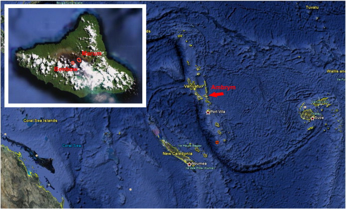
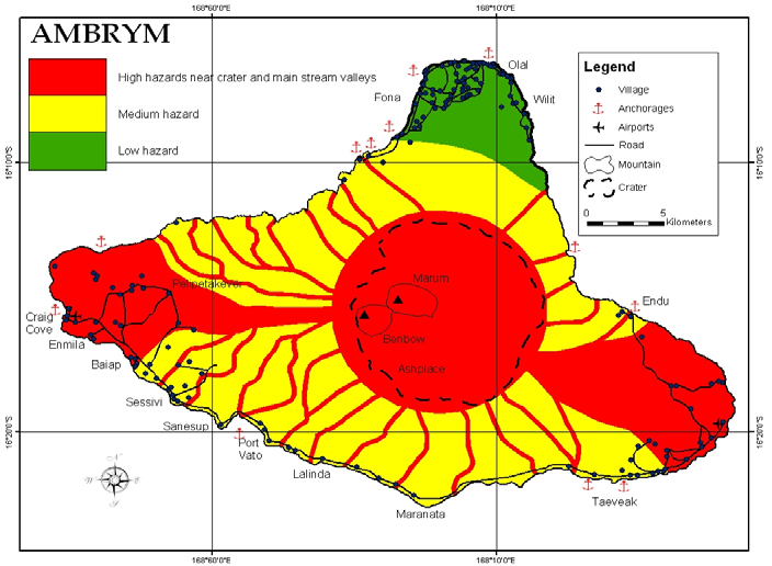
In our previous Ambrym report, we described ongoing plumes, some bearing ash rising to over 6 km altitude through early June 2011 (BGVN 36:05). The volcano has been known to contain two molten, turbulent lava lakes since August 1999, and that continues at least through June 2011, which was the last time lava-lake activity was noted in a report by the Vanuatu Geohazards Observatory (VGO). Our reporting observations drew heavily on government reports of 3 April 2009 and 29 July 2013. The former report also discussed water supply and other issues of public health and safety associated with inhabiting an active volcano. Vanuatu is located in the South Pacific NE of Australia (figures 24 and 25).
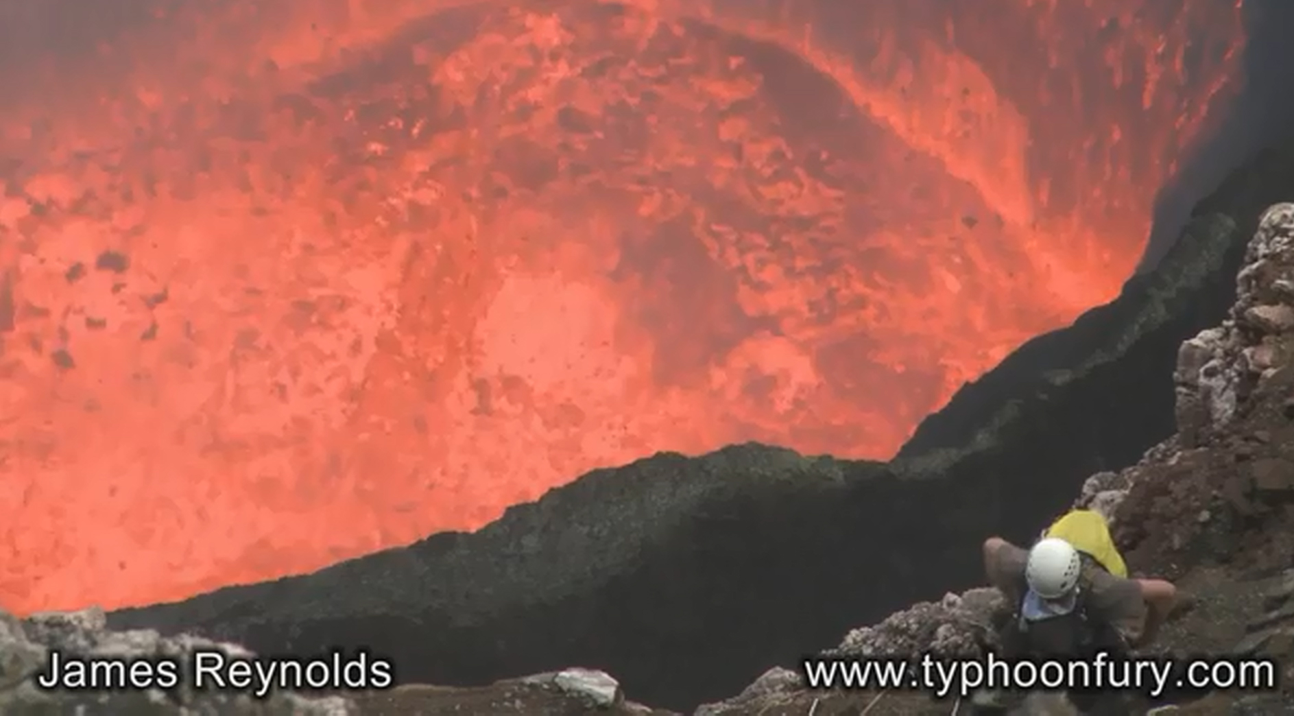
Reynolds (2010) posted videos of lava lake behavior seen in September 2010. Figure 26 is a screenshot taken from the Reynolds' video of the turbulent lava lake with a climber in the foreground. The high definition videos showed an exceedingly agitated lake surface, everywhere disturbed and molten, without any chilled material in evidence. Violent upwellings of lava occurred continuously. Some fraction of the videos show climbers in the foreground, at one point descending a steep slope or vertical drop by a single rope secured from above (abseiling or rappelling).
 |
Figure 26. A screen capture from a video of Marum, one of Ambrym's two active lava lakes, taken on unstated day in September 2010. Courtesy of James Reynolds (typhoonfury.com and earthuncut.tv). |
On 27 June 2011, the VGO reported that data collected from Ambrym's monitoring network showed significant daily degassing and occasional explosions in the crater. Field observers noted that the level of the lava lakes was high. During June, villages reported minor ashfall and that acid rain affected agriculture in general in some areas W, S, and E. The Alert Level remained at 1 (on a scale of 0-4).
During the previous 12 months prior to mid-July 2013, MODVOLC thermal alerts were frequent, on the order of several a week to multiple per day, as would be expected for a volcano with active lava lakes. The alerts referred to the lava lakes in Benbow and Marum craters (figure 25).
On 21 June 2013, VGO reported that satellite images on 2, 4, 11, 14, and 16 June detected gas emissions from Ambrym. Emissions of minor amounts of ash and substantial amounts of gas from the active vents had been detected during the previous week. The report warned that communities on the island, especially those downwind of Ambrym, may experience ashfall and acid rain that could damage the environment and contaminate water. The Alert Level remained at 1. Based on pilot observations and analyses of satellite imagery, the Wellington Volcanic Ash Advisory Center (VAAC) reported that on 19 July 2013 an ash plume rose to an altitude of 3 km a.s.l. and drifted 185 km NW.
VGO reported that activity at Ambrym slightly increased to a minor eruptive phase, and a seismic swarm was detected between 2400 and 0700 on 26 July 2013. The Alert Level remained at 1.
Gas fluxes are generally high for Vanuatu volcanoes and have been the subject of regular reporting online and several recent reports in the literature (for example, Bani and others, 2009; Bani and others, 2012).
References. Bani, P., C. Oppenheimer, V.I. Tsanev, S.A. Carn, S.J. Cronin, R. Crimp, J.A. Calkins, D. Charley, M. Lardy, and T.R. Roberts, 2009, Surge in sulfur and halogen degassing from Ambrym volcano, Vanuatu, Bulletin of Volcanology, 71(10), 1159-1168, doi:10.1007/s00445-009-0293-7.
Bani, P., C. Oppenheimer, P. Allard, H. Shinohara, V. Tsanev, S. Carn, M. Lardy, and E. Garaebeti, 2012, First arc-scale volcanic SO2 budget for the Vanuatu archipelago, Journal of Volcanology and Geothermal Research, 211-212, 36-46, doi:10.1016/j.jvolgeores.2011.10.005.
Polacci, M, Baker, D, La Rue, A., Mancini, L., Allard, P., 2012, Degassing behaviour of vesiculated basaltic magmas: an example from Ambrym volcano, Vanuatu Arc, Journal of Volcanology and Geothermal Research, Vol. 233-234, 1 July 2012, pp. 55-64.
Reynolds, J., 2010, (Video) Abseiling towards a lava lake--extreme video From Marum volcano, Ambrym, Vanuatu (September 2010) YouTube (URL: https://www.youtube.com/watch?v=AtGT-_7Xoal) [also available at typhoonfury.com and earthuncut.tv].
Geological Summary. Ambrym, a large basaltic volcano with a 12-km-wide caldera, is one of the most active volcanoes of the New Hebrides Arc. A thick, almost exclusively pyroclastic sequence, initially dacitic then basaltic, overlies lava flows of a pre-caldera shield volcano. The caldera was formed during a major Plinian eruption with dacitic pyroclastic flows about 1,900 years ago. Post-caldera eruptions, primarily from Marum and Benbow cones, have partially filled the caldera floor and produced lava flows that ponded on the floor or overflowed through gaps in the caldera rim. Post-caldera eruptions have also formed a series of scoria cones and maars along a fissure system oriented ENE-WSW. Eruptions have apparently occurred almost yearly during historical time from cones within the caldera or from flank vents. However, from 1850 to 1950, reporting was mostly limited to extra-caldera eruptions that would have affected local populations.
Information Contacts: Vanuatu Geohazards Observatory, Department of Geology, Mines and Water Resources of Vanuatu (URL: http://geohazards.gov.vu/); Hawai'i Institute of Geophysics and Planetology (HIGP), MODVOLC Thermal Alerts System, School of Ocean and Earth Sciences and Technology (SOEST), Univ. of Hawai'i, 2525 Correa Road, Honolulu, HI 96822, USA (URL: http//hotspot.higp.hawaii.edu/); Wellington Volcanic Ash Advisory Centre (VAAC) (URL: http://vaac.metservice.com/); and NASA Global Sulfur Dioxide Monitoring Home Page, Goddard Space Flight Center, Sciences and Exploration Atmospheric Chemistry and Dynamics Laboratory, Code 614 (URL: http://so2.gsfc.nasa.gov/, http://so2.gsfc.nasa.gov/pix/daily/0813/vanuatu_0813z.html).


