Report on Whakaari/White Island (New Zealand) — February 2014
Bulletin of the Global Volcanism Network, vol. 39, no. 2 (February 2014)
Managing Editor: Richard Wunderman.
Whakaari/White Island (New Zealand) Dome extrusion in late 2012 and further eruptions in 2012-2013
Please cite this report as:
Global Volcanism Program, 2014. Report on Whakaari/White Island (New Zealand) (Wunderman, R., ed.). Bulletin of the Global Volcanism Network, 39:2. Smithsonian Institution. https://doi.org/10.5479/si.GVP.BGVN201402-241040
Whakaari/White Island
New Zealand
37.52°S, 177.18°E; summit elev. 294 m
All times are local (unless otherwise noted)
On 5 August 2012, White Island erupted, following rapid water level rises in the crater lake. Minor ash emission continued to as late as 17 August (BGVN 37:06). This report describes activity during September 2012-January 2014. Unless otherwise stated, information was compiled from GeoNet reports. Major events during the reporting interval include a spiny dome first viewed in December 2012, several months of explosive phreatic activity in early 2013, and discrete explosive eruptions during the latter half of 2013. Magma last surfaced at White Island in 2000 in an explosive eruption that ejected molten lava (BGVN 25:08). GeoNet, a monitoring project funded by the Earthquake Commission, is operated by New Zealand's GNS Science which produces an on-line Volcanic Alert Bulletin. It monitors volcano events by webcam, and acoustic and seismic instruments. Periodically, in situ temperature, fumarole and spring chemical sampling, deformation, gas data, and visual narratives were also recorded. Surveillance includes a mini DOAS network and may also airborne visual observations, photos, and IR images.
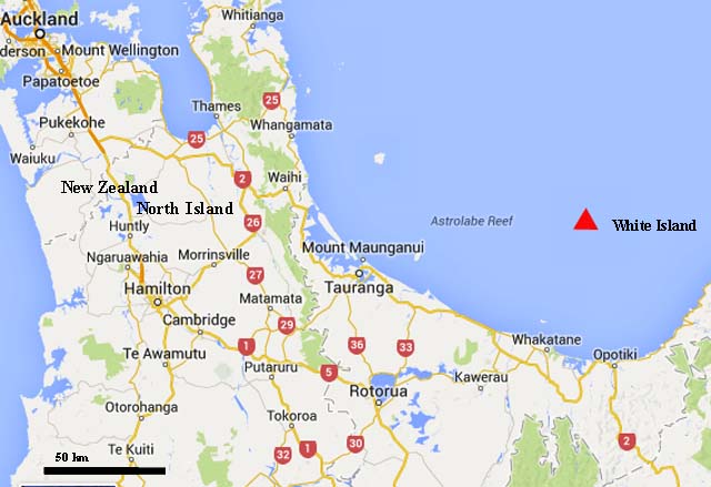
GeoNet currently describes White Island as the most active of New Zealand's volcanoes. During 2012 and 2013 normal seismic activity was interspersed with periods of heightened activity. GeoNet reported minor ash, seismicity, gas emissions, dome building, and changes at the crater and crater lakes. Two significant eruptions occurred after a period of reduced activity in 2013: one in August and the other in October. In January 2014, GeoNet volcanologists reported low seismicity. During a single year, tour companies estimated that over 10,000 tourists visited White Island from NZ's North Island ~45 km to the S. Safety of visitors to the island and surrounding waters depends on Volcanic Alert Bulletins. The NZ volcano alert levels ranged from 0 (low risk) to 5 (high risk); Aviation Alert colors ranged from Green (low risk), to Yellow, to Orange and then to Red (high risk). These two alert types were frequently updated, based on spikes in activity. For example in August 2013, Alert Levels ranged from 1 to 2 and Aviation Colour Codes shifted from Yellow to Green to Red to Orange and back to Yellow.
Ashfall in 2012 and a spiny lava dome. In a Volcanic Alert Bulletin issued on 12 December 2012, GNS reported that after the 5 August eruption, a spiny done was formed. In the 26 July 2013 report, phreatic and steam driven activity was observed beginning in December with minor ash emissions interspersed and continuing into the following year. Degassing and tremors were frequent with varying intensities (figure 55). The figure records seismicity as root square amplitude mean (RSAM) on the ordinate plotted along the time line abscissa from June 2007 to December 2013. The tremors were generally attributed to fluid movement (magma, geothermal water, and steam) at an undetermined depth in the crust.
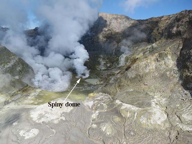
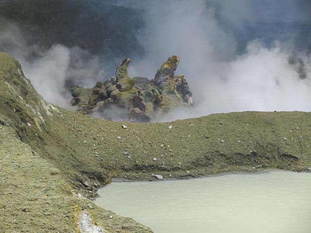
In December 2012, two airborne observations were conducted. GNS volcanologists on 10 December viewed for the first time a small spiny lava dome in the crater active during August 2012. The dome emerged in the vent active in a spot adjacent to two other venting areas (figure 56). GNS reporting attributed the dome morphology to a cooled carapace thrust upward by injection of magma deeper in the dome. Several spines protruded from the roughly 20-30 m diameter dome base (figure 57). Tour operators to the island commented that the dome was visible weeks before the volcanologists viewed it. The actual date of formation remained unstated and possibly unknown.
Airborne observations on 20 December 2012 found the lava dome unchanged. Several small lakes occupied parts of the area formally covered by a large lake viewed before the August eruption. Infrared temperatures taken during the flight found the dome to be 187°C, the actively upwelling hot lake S of the dome to be 71°C, and the cool lake on the N side of the dome to be 35°C. 20 December airborne measurements resulted in a gas flux rate for SO2 of 400 metric tons/day (t/d), for CO2: 1,300 t/d, and for H2S2; 10 t/d.
Ashfall after the August 2012 eruption to the end of 2012 was unreported in the 2012 Volcanic Alert Bulletin archive. However, in the 26 July 2013 report, GeoNet summarized the December 2012-February 2013 activity as an eruption sequence interspersed with phreatic, steam driven activity and very minor ash emissions. Ashfall in December 2012 and January-February 2013 are reported in table 12. Exact ashfall dates were unreported due to the minor nature of ashfall events and irregular visits. Table 12 summarizes eruptive activity at White Island during this report period.
Table 12. December 2012-11 October 2013 eruptive activity at White Island. Column headings are eruptions, seismicity, and a brief eruptive narrative. Dates in the second column from the right came from Volcanic Alert Bulletin reports. Notes refer to image and video records found in the Reference section under GNS. Courtesy of GNS.
| Date | Emissions | Seismicity noted | Eruptive narrative | GeoNet report | Notes |
| 1 Dec 2012 | Small phreatic explosions, minor ash | Elevated RSAM levels | Intermittent eruptions | 26 Jul 2013 | -- |
| Jan-Feb 2013 | Phreatic explosions, minor ash | Elevated RSAM levels | Intermittent emissions | 26 Jul 2013 | -- |
| 23-24 Feb 2013 | Phreatic explosions, minor ash | Increased tremor | Intermittent emissions | 25 Feb 2013 | -- |
| Early Apr 2013 | Mud and ash eruption | Tremor, outgassing | Crater lake starts to form | 29 Apr 2013 | -- |
| 20 Aug 2013 | Small explosive eruption | Tremor | White plume ~4 km | 20 Aug 2013 | 1,2 |
| 4,8,11 Oct 2013 | Small explosive eruptions | -- | Minor ash columns | 12 Oct 2013 | 3 |
Ashfall in 2013, 20 August eruption, and 11 October eruption. On 1 January 2013, GNS volcanologists reported the spiny lava dome (figure 58) remained unchanged from December 2012. The lava dome temperature was 200-240°C, up from 187°C in December, and the nearby 'hot lake' was 70-80°C, unchanged from December.
GNS volcanologist Brad Scott, who visited the island, commented in the 22 January Volcano Alert Bulletin "the hydrothermal activity is some of the most vigorous I have seen at White Island for many years." Scott also reported the hot lake had disappeared, replaced by a small tuff cone. That cone was the main point of emission for steam and gas. On 30 January 2013, the active vent continued to produce intermittent vigorous bursts of mud, rock, steam, and gas rising 50-100 m high without detectable ash in the plume. On 31 January, gas fluxes were 2,000 metric tons per day (t/d) for carbon dioxide (CO2), 600 t/d for sulfur dioxide (SO2), and 19 t/d for hydrogen sulfide (H2S).
On 7 February, SO2 and CO2 rates were similar to measurements in January: SO2 was 560 t/d and CO2 was 1,800 t/d. The main steam and gas plume came from the ash cone occupying the previous hot lake crater. Small explosive eruptions in the active crater and seismicity, which had been occurring for three weeks prior to the week of 11 February, became less intense.
During 23-24 February 2013 minor ash erupted from the active vent. Tremor was consistent with the level of unrest seen over the past month. On 25 February, the ash emissions had ceased and had been replaced by steam-and-gas explosions from the active vent. The level of volcanic tremor increased, associated with the reappearance of fluids in the vent area (figure 55). The unrest was among the most vigorous that Scott had observed during visits to White Island. He was quoted in the 25 February report to say "the unrest continues and we continue to see small scale explosive events. Larger explosive eruptions can occur at any time with little or no warning. As always a high level of caution should be taken if visiting the island."
The crater on 4 March 2013 contained an ash cone surrounded by water (figure 59), which replaced the previous hot lake as the primary source of steam in the crater. On 29 April 2013, GNS reported that ash had ceased being emitted at an undisclosed date during the first part of the month. In April, low to moderate seismic tremor was detected, while degassing continued. Rainfall during April caused the two lakes to combine. The maximum lake temperature was ~ 62°C. The lava dome temperature was ~200°C.
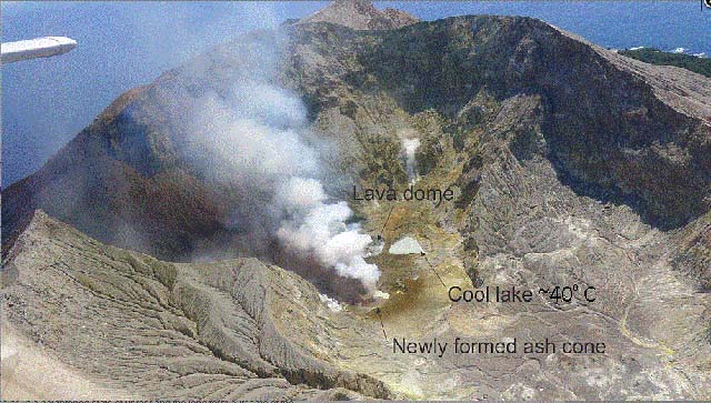 |
Figure 59. A 4 March 2013 image looking W ~600 m from the crater. A new ash cone formed at the hot lake emitted gas and steam. N of the ash cone sits the cool lake. Image by B. J. Scott, GNS Science. |
During April, May, and June 2013 the crater lake reformed. On 9 July 2013 GNS reported small volcanic earthquakes occurred approximately every 70 seconds, with changing amplitude and frequency. GNS volcanologists visiting on 26 July observed gas venting through the small lake with debris ejected 20-30 m vertically. By 5 August this minor venting had declined and tremor had decreased to near-background levels (see figure 55).
A small eruption took place in August 2013 detected by a constellation of instruments on White Island which included audio receivers, seismometers, temperature sensors, and IR sensors. The eruption was captured on video media by several cameras near the crater rim and a camera stationed ~45 km S at NZ's North Island (figure 60). The eruption occurred at 1023 on 20 August 2013 (NZ local time) and continued for about 10 minutes. As seen from the mainland, it mainly produced a steam plume rising to ~4 km, and slowly trending W before dispersing (figure 61). The eruption originated from a vent in the active crater that had been experiencing very small mud eruptions in early to mid-August 2013. This eruption was preceded by strong tremor.
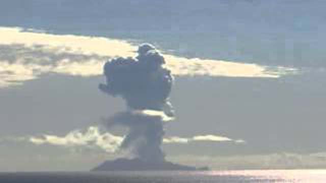 |
Figure 61. Image of White Island taken from Whakatane WebCam video of the 20 August 2013 eruption. The image was in the GNS 22 August 2013 report. Courtesy of Geonet. |
The N rim webcam captured visual and thermal infrared images of the eruption. Both the N Island camera and the N rim camera video links were included in the GNS 22 August report. The 20 August eruption ejected mud and rocks a short distance from the vent and produced large volumes of white steam. Weather radar observations suggested that the steam also contained a small proportion of volcanic ash. The hazards posed by the eruption were restricted to the island or possibly vessels anchored nearby. By 21 August 2013, White Island activity had diminished. Volcanologists flying over the island on 23 August observed the return of a small lake. Steam emissions chiefly emerged from the cone area, but their intensity dropped as the small lake reformed. SO2, CO2, and H2S gases recorded during the flight had diminished to pre-eruption levels.
The 7 October GNS report described the changes associated with the August 2013 eruption. A new basin further to the NE of the previous lake filled with water. The lava dome area appeared unchanged while nearby a small pond had formed. Landslides had altered several of the main crater walls, the result of processes most likely related to weather events. Daily SO2 gas flux measured the previous month ranged from 117 to 662 t/d, typical of the last 12-18 months but higher than before July 2012. In early October it remained elevated.
A moderate but potentially dangerous eruption emerged on 11 October 2013. The eruption sequence began 4 October, with a small energetic steam emission followed by intensified tremor. On 8 October, a period of strong seismicity prevailed accompanied by acoustic signals, and a minor steam and mud eruption that produced a steam plume. During the evening of 11 October, a moderate explosive eruption lasted ~1 minute based on data from acoustic and seismic sensors. The N rim camera images showed that the eruption emerged from the crater's central vent. The explosive eruption produced an ash cloud that expanded across the main crater floor. New mud deposited on the crater floor was evident in the web camera images taken the following day (figure 63). The deposit was thick enough to bury much of the small scale topography on parts of the crater floor. This image and the muddy stratigraphic layer established the baseline for subsequent changes created by volcanism and erosion.
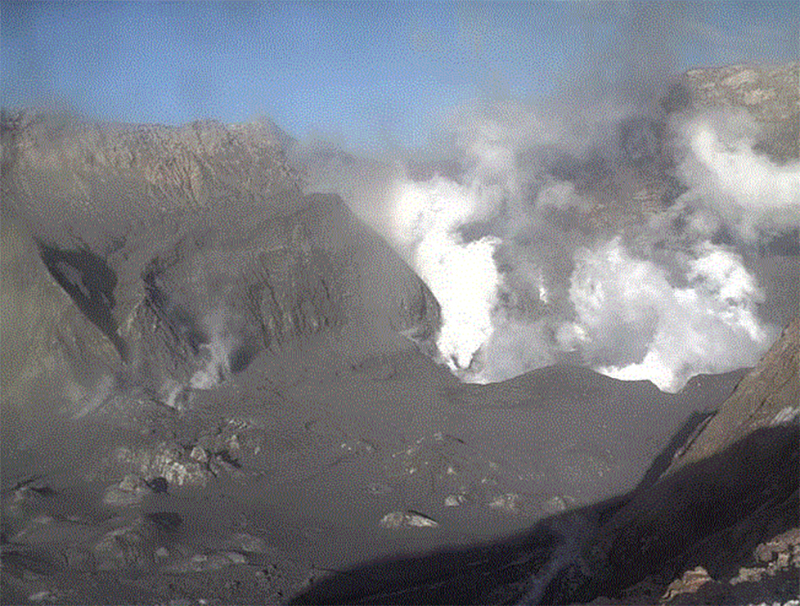 |
Figure 62. On 12 October 2013 at 0650, the crater floor and walls lie draped beneath fresh deposits of dark gray mud from the eruption the night before. Courtesy of Geonet. |
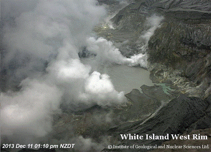
The October 2013 mud eruption was the largest of recent events. GNS volcanologists estimated it would have been life threatening to people on the island. Volcanic tremor gradually decreased after 11 October returning to levels equivalent to the middle of the prior week (see figure 55). The mud deposited on 11 October 2013 had clearly begun to erode by early December 2013. Around this time a new camera on the W rim captured active steam-and-gas plumes from several vents and the large lake seen in 2012 (figure 63). On 23 December 2013 GNS reported an absence of eruptive activity since the 11 October eruption. Seismicity remained low; gas flux, variable. Average daily SO2 flux ranged from 300 to over 1,000 t/d. Prior to 2012, daily averages were generally less than 300 t/d.
January 2014 changes to the crater and rate of gas emitted. During several January visits, GNS Science staff observed a continued rise in water level of the crater lake, reaching ~5 m higher than in late 2013. The average daily SO2 flux ranged from 133 to 924 t/d. GNS volcanologists reported an absence of further eruptive activity since the 11 October 2013 eruption.
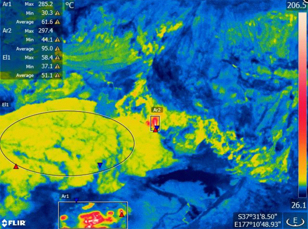
On 15 January 2014, a thermal infrared image was taken by a portable infrared sensor pointed W from the western crater rim (figure 64). The image shows part of the Crater Lake (oval labeled El1), the area of the 2012 lava extrusion below the lake (large rectangular box labeled Ar1), and a hot fumarole on the S edge of the Crater Lake (small rectangle in the center labeled Ar2). Maximum temperatures were 58°C at the lake, 285°C forAr1, and 297°C for Ar2. These observations confirmed that hot volcanic gases were still passing through these vents.
References.
100% New Zealand, accessed 5 May 2014, New Zealand Map (URL: http://www.newzealand.com/int/map/).
GNS (22 August 2013), White Island eruption 20 August 2013 - 5x speed, (URL: http://info.geonet.org.nz/display/volc/2013/08/20/White+Island+Eruption.)
GNS (22 August 2013), White Island eruption 20 August 2013 Crater rim - 5x speed, (URL: http://info.geonet.org.nz/display/volc/2013/08/20/White+Island+Eruption).
GNS (14 October 2012), Un-named video clip URL reference in body of GNS report (URL: http://info.geonet.org.nz/pages/viewpage.action?pageId=7241739).
Geological Summary. The uninhabited Whakaari/White Island is the 2 x 2.4 km emergent summit of a 16 x 18 km submarine volcano in the Bay of Plenty about 50 km offshore of North Island. The island consists of two overlapping andesitic-to-dacitic stratovolcanoes. The SE side of the crater is open at sea level, with the recent activity centered about 1 km from the shore close to the rear crater wall. Volckner Rocks, sea stacks that are remnants of a lava dome, lie 5 km NW. Descriptions of volcanism since 1826 have included intermittent moderate phreatic, phreatomagmatic, and Strombolian eruptions; activity there also forms a prominent part of Maori legends. The formation of many new vents during the 19th and 20th centuries caused rapid changes in crater floor topography. Collapse of the crater wall in 1914 produced a debris avalanche that buried buildings and workers at a sulfur-mining project. Explosive activity in December 2019 took place while tourists were present, resulting in many fatalities. The official government name Whakaari/White Island is a combination of the full Maori name of Te Puia o Whakaari ("The Dramatic Volcano") and White Island (referencing the constant steam plume) given by Captain James Cook in 1769.
Information Contacts: GeoNet, a collaboration between the Earthquake Commission and GNS Science (URL: http://www.GeoNet.org.nz/); and GNS Science, Wairakei Research Center, Private Bag 2000, Taupo 3352, New Zealand (URL: http://www.gns.cri.nz/).


