Report on Ambrym (Vanuatu) — April 2014
Bulletin of the Global Volcanism Network, vol. 39, no. 4 (April 2014)
Managing Editor: Richard Wunderman.
Ambrym (Vanuatu) Frequent thermal alerts and gas emissions continue
Please cite this report as:
Global Volcanism Program, 2014. Report on Ambrym (Vanuatu) (Wunderman, R., ed.). Bulletin of the Global Volcanism Network, 39:4. Smithsonian Institution. https://doi.org/10.5479/si.GVP.BGVN201404-257040
Ambrym
Vanuatu
16.25°S, 168.12°E; summit elev. 1334 m
All times are local (unless otherwise noted)
Our previous report on Ambrym (BGVN 38:05) indicated that daily degassing and an infrequent ash plume occurred through July 2013, along with frequent MODVOLC thermal alerts, consistent with the hot molten surface of the volcano's active lava lakes. The volcano, whose location was shown in the previous report in figure 27, consists of two craters, Marum and Benbow, each with a lava lake. According to the Vanuatu Geohazards Observatory (VGO), the last known eruption was in 2009. The island of Ambrym has ~7,000 inhabitants, many of whom live within the hazard zone (see figure 28 in BGVN 38:05). This report updates information through July 2014.
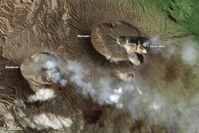
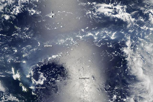
According to NASA's Earth Observatory, a satellite image acquired on 9 August 2013 showed steam-and-gas plumes rising from Ambrym's Benbow cone and from the active lava lake in Mbwelesu Crater (one of three active sub-craters of the Marum cone) (figure 27). Another Earth Observatory image on 7 January 2014 showed a plume from Ambrym spreading across the South Pacific Ocean (figure 28). The strong reflection of the sun off the sea surface is called "sunglint."
As in previous years, MODVOLC thermal alerts during the reporting period were frequent, ranging from several per week to multiple times per day. This activity is consistent with the presence of active lava lakes.
According to VGO, the current alert level remains in mid-2014 at 1 (increased activity, danger near crater only).
Geological Summary. Ambrym, a large basaltic volcano with a 12-km-wide caldera, is one of the most active volcanoes of the New Hebrides Arc. A thick, almost exclusively pyroclastic sequence, initially dacitic then basaltic, overlies lava flows of a pre-caldera shield volcano. The caldera was formed during a major Plinian eruption with dacitic pyroclastic flows about 1,900 years ago. Post-caldera eruptions, primarily from Marum and Benbow cones, have partially filled the caldera floor and produced lava flows that ponded on the floor or overflowed through gaps in the caldera rim. Post-caldera eruptions have also formed a series of scoria cones and maars along a fissure system oriented ENE-WSW. Eruptions have apparently occurred almost yearly during historical time from cones within the caldera or from flank vents. However, from 1850 to 1950, reporting was mostly limited to extra-caldera eruptions that would have affected local populations.
Information Contacts: MODVOLC - HIGP, Hawai'i Institute of Geophysics and Planetology (HIGP), MODVOLC Thermal Alerts System, School of Ocean and Earth Science and Technology (SOEST), Univ. of Hawai'i, 2525 Correa Road, Honolulu, HI 96822, USA (URL: http://modis.higp.hawaii.edu/); NASA Earth Observatory, EOS Project Science Office, NASA Goddard Space Flight Center, Goddard, Maryland, USA (URL: http://earthobservatory.nasa.gov/); and Vanuatu Geohazards Observatory (VGO) (URL: http://www.geohazards.gov.vu).


