Report on Hekla (Iceland) — September 2014
Bulletin of the Global Volcanism Network, vol. 39, no. 9 (September 2014)
Managing Editor: Richard Wunderman.
Hekla (Iceland) Elevated seismicity during March-April 2013
Please cite this report as:
Global Volcanism Program, 2014. Report on Hekla (Iceland) (Wunderman, R., ed.). Bulletin of the Global Volcanism Network, 39:9. Smithsonian Institution. https://doi.org/10.5479/si.GVP.BGVN201409-372070
Hekla
Iceland
63.983°N, 19.666°W; summit elev. 1490 m
All times are local (unless otherwise noted)
Introduction. This Bulletin report covers the unusual seismic activity recorded at Hekla from early March through April 2013. The last Bulletin report (BGVN 25:06) on Hekla clarified errors concerning NASA's airborne plume experiments on 29 February 2000, which occurred during Hekla's last eruption.
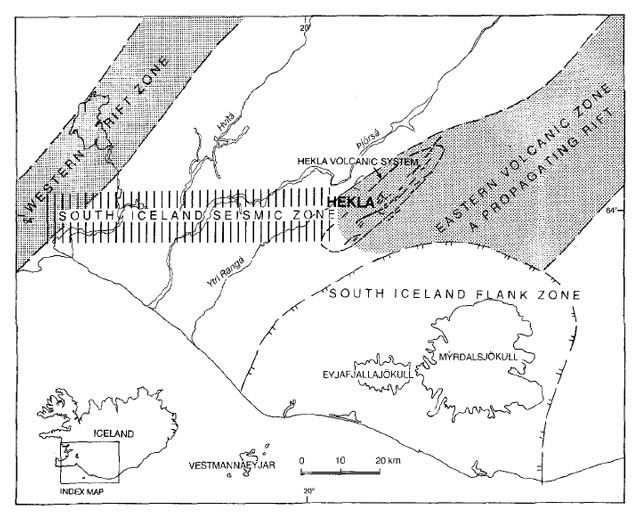
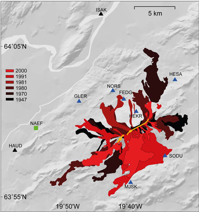
Several references have been included to provide more information on Hekla's most recent eruptions in 1991 and 2000. Below are also two maps showing Hekla's location and lava flows created during some of Hekla's eruptions (figures 2 and 3).
March 2013. On 10 March 2013, the Icelandic Meteorological Office (IMO) began detecting micro-earthquakes at Hekla. The IMO detected at least 7 high-frequency earthquakes whose magnitudes ranged from 0.4-1. The earthquakes were recorded over a small area approximately 4.5 km to the NE of Hekla's summit with a source 11-12 km below the surface. The earthquakes were judged as the result of brittle fracture rather than a consequence of magma moving. It is important to note a clustering of earthquakes such as these is uncommon during non-eruption periods at Hekla.
The IMO informed the National Commissioner of the Icelandic Police (NCIP) of the occurrence of these earthquakes. This type of activity had not been seen since Hekla's last eruption. With this information the NCIP and the Police Commissioner at Hvolsvöllur declared an 'uncertainty phase', which is the lowest of three warning level regarding natural hazards. The IMO also changed the Aviation Colour Code from Green to Yellow. The Aviation Colour Code is a 5-level color code scale that informs the aviation community of a volcano's status. The 5 levels in order of increasing volcanic activity are Grey, Green, Yellow, Orange and Red. According the IMO website, the Yellow color code signifies that a "volcano is experiencing signs of elevated unrest above known background levels or, after a change from [a] higher alert level…"
On 28 March, no seismic activity was detected at Hekla for ~4 days. No obvious signs of an imminent eruption were reported. Nevertheless, the 'uncertainty phase' warning level was kept in effect and the Aviation Colour Code remained Yellow. For the last few days of March 2013, no new activity was reported.
April 2013. For the first three days of April, Hekla remained quiet, but the 'uncertainty phase' warning level remained in effect. On 4 April, the IMO changed the Aviation Colour Code from Yellow to Green. No changes in gas or heat were observed at Hekla's summit and no crustal movement was detected. Due to the low activity, the 'uncertainty phase' warning level was removed.
Hekla continued to be quiet until 26 April, when an M 1.1 earthquake occurred in the same area as the earthquakes in March. No other activity was reported at Hekla for the rest of April.
References. Aviation Colour Code map, Icelandic Meteorological Office, date accessed 17 March 2015, (URL: http://en.vedur.is/weather/aviation/volcanic-hazards/ )
Gudmundsson, A., Oskarsson, N., Grönvold, K., Saemundsson, K., Sigurdsson, O., Stefansson, R., Gislason, S., Einarsson, P., Brandsdottir, B., Larsen, G., Johannesson, H., and Thordarson, T., 1992, The 1991 eruption of Hekla, Iceland, Bulletin of Volcanology, v54, pp 238-246, date accessed 16 March 2015 (URL: http://link.springer.com/article/10.1007/BF00278391 )
Hekla volcano 2013-daily reports, Trip to Iceland, 27 March 2013, date accessed March 17, 2015, (URL: http://www.trip-to-iceland.com/culture/hekla-volcano-2013-daily-reports/ )
Höskuldsson, Á., Óskarsson N., Pedersen, R., Grönvold, K., Vogfjörð, K., and Ólafsdóttir, R., 2007, The Millennium Eruption of Hekla in February 2000. Bulletin of Volcanology, v70 (2), pp 169-82, DOI 10.1007/s00445-007-0128-3, data accessed 16 March 2015 (URL: http://link.springer.com/article/10.1007/s00445-007-0128-3# )
Seismic activity in Mount Hekla, Icelandic National Broadcasting Service (RUV), 26 March 2013, date accessed 17 March 2015, (URL: http://www.ruv.is/frett/seismic-activity-in-mount-hekla)
Soosalu, H. and Einarsson P., 2001, Earthquake Activity Related to the 1991 Eruption of the Hekla Volcano, Iceland, Bulletin of Volcanology, v63(8), pp 536-544, DOI 10.1007/s00445-001-0177-y, date accessed 16 March 2015 (URL: http://link.springer.com/article/10.1007/s00445-001-0177-y# )
Soosalu, H., Einarsson, P., and Jakobsdóttir, S., 2003, Volcanic tremor related to the 1991 eruption of the Hekla volcano, Iceland, Bulletin of Volcanology, v65, pp 562-577, DOI 10.1007/s00445-003-0285-y, date accessed 16 Mar 2015 (URL: http://link.springer.com/article/10.1007/s00445-003-0285-y#page-1)
Soosalu, H., Einarsson P., and Þorbjarnardóttir, B. S., 2005, Seismic Activity related to the 2000 Eruption of the Hekla Volcano, Iceland, Bulletin of Volcanology, v68(1), pp21-36, DOI 10.1007/s00445-005-0417-7, date accessed 16 March 2015 (URL: http://link.springer.com/article/10.1007/s00445-005-0417-7)
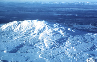
Geological Summary. One of Iceland's most prominent and active volcanoes, Hekla lies near the southern end of the eastern rift zone. Hekla occupies a rift-transform junction, and has produced basaltic andesites, in contrast to the tholeiitic basalts typical of Icelandic rift zone volcanoes. Vatnafjöll, a 40-km-long, 9-km-wide group of basaltic fissures and crater rows immediately SE of Hekla forms a part of the Hekla-Vatnafjöll volcanic system. A 5.5-km-long fissure, Heklugjá, cuts across the 1491-m-high Hekla volcano and is often active along its full length during major eruptions. Repeated eruptions along this rift, which is oblique to most rifting structures in the eastern volcanic zone, are responsible for Hekla's elongated ENE-WSW profile. Frequent large silicic explosive eruptions during historical time have deposited tephra throughout Iceland, providing valuable time markers used to date eruptions from other Icelandic volcanoes. Hekla tephras are generally rich in fluorine and are consequently very hazardous to grazing animals. Extensive lava flows from historical eruptions, which date back to 1104 CE, cover much of the volcano's flanks.
Information Contacts: Icelandic Meteorological Office, Bustadavegur 7-9, 108 Reykjavík, Iceland (URL: http://en.vedur.is/); National Commissioner of the Icelandic Police (NCIP), Civil Protection and Emergency Management Department, Skúlagata 21, 101 Reykjavík, Iceland (URL: http://www.almannavarnir.is/displayer.asp?cat_id=133); and Sigrún Hreinsdóttir, GNS Science, PO Box 30368 1 Fairway Drive, Lower Hutt, 5010 New Zealand (URL: http://www.gns.cri.nz/).


