Report on Copahue (Chile-Argentina) — April 2017
Bulletin of the Global Volcanism Network, vol. 42, no. 4 (April 2017)
Managing Editor: Edward Venzke.
Research and preparation by Jackie Gluck.
Copahue (Chile-Argentina) Eruptive activity consisting of Strombolian explosions and gas-and-ash plumes ends in late December 2016
Please cite this report as:
Global Volcanism Program, 2017. Report on Copahue (Chile-Argentina) (Venzke, E., ed.). Bulletin of the Global Volcanism Network, 42:4. Smithsonian Institution. https://doi.org/10.5479/si.GVP.BGVN201704-357090
Copahue
Chile-Argentina
37.856°S, 71.183°W; summit elev. 2953 m
All times are local (unless otherwise noted)
Recent activity at Copahue through January 2016 (BGVN 41:03) consisted of gas and steam plumes with minor amounts of ash. This report, based on information obtained from the Buenos Aires Volcanic Ash Advisory Center (VAAC), the Southern Andes Volcanological Observatory (OVDAS), and the Servicio Nacional de Geología y Minería (National Geology and Mining Service) (SERNAGEOMIN), covers similar activity from mid-January through December 2016. Volcano Alert Levels were maintained by SERNAGEOMIN (on a four-color scale) and by the Chilean Oficina Nacional de Emergencia del Ministerio del Interior (National Office of Emergency of the Interior Ministry) (ONEMI), on a three-color scale), for alerts to individual communes in the region.
Reports from the Buenos Aires VAAC between 13 January and 26 March 2016, based on Significant Meteorological Information (SIGMET) notices, satellites, and webcam views, indicated continuous gas-and-steam plumes containing minor amounts of ash. The plumes rose as high as 3.3-4.3 km altitude (during 24-25 and 28 February) and drifted as far as 160 km (trending SE and SW) between 28 January and 2 February, and more generally as far as 150 km in a variety of directions.
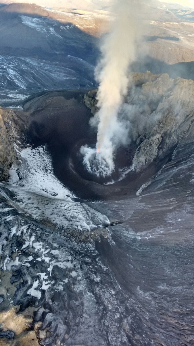
The Buenos Aires VAAC next reported steam-and-gas emissions, possibly containing minor amounts of ash on 11 June, based on webcam recordings. OVDAS-SERNAGEOMIN reported an eruption during 16-30 June characterized by phreato-magmatic explosions and Strombolian activity. During an overflight on 3 July, SERNAGEOMIN scientists observed Strombolian activity from a pyroclastic cone that was forming on the floor of El Agrio crater (figure 17).
 |
Figure 17. Photo taken during an overflight of Copahue on 3 July 2016 showing Strombolian activity from a pyroclastic cone on the floor of El Agrio crater. Courtesy of SERNAGEOMIN. |
Based on webcam and satellite views, the Buenos Aires VAAC reported that during 7-8 July diffuse gas-and-steam plumes with minor amounts of ash rose to an altitude of 3 km and drifted E and SE. The Alert Level remained at Yellow (second highest level on a four-color scale).
Activity renewed in September and lasted through December 2016. Based on satellite and webcam images, notices from the Buenos Aires VAAC after 23 September described gas and water vapor plumes with minor ash content rising above the summit. The plumes rose as high as 5.2 km a.s.l. (during 23-25 and 27-29 November) and drifted based on wind direction SW, S, SSE, ESE, SE, E, ENE, NE, and N. On 2 December OVDAS-SERNAGEOMIN reported that activity continued to be dominated by weak Strombolian explosions, likely from a pyroclastic cone forming on the floor of El Agrio crater. The last VAAC reports of activity during 2016 were for gas-and-ash emissions to altitudes of 3.6-3.9 km drifting in S and E directions.
The only MODVOLC thermal anomaly during the entire reporting period was on 26 October 2016 (1 pixel). The MIROVA volcano hotspot detection system, also based on analysis of MODIS data, detected low level thermal anomalies that became more frequent during the latter part of June through early July 2016 and thereafter occurred less often. The last anomalies recorded by MIROVA (as of early April 2017) were in about the third week of December 2016 (figure 18).
 |
Figure 18. Plot of thermal anomalies at Copahue as recorded by the MIROVA system (Log Radiative Power), April 2016-March 2017. Courtesy of MIROVA. |
At some point after the December 2016 activity, SERNAGEOMIN lowered the Alert Level to Green, the lowest of the four levels. No additional reports of activity were issued from any agency through March 2017.
Geological Summary. Volcán Copahue is an elongated composite cone constructed along the Chile-Argentina border within the 6.5 x 8.5 km wide Trapa-Trapa caldera that formed between 0.6 and 0.4 million years ago near the NW margin of the 20 x 15 km Pliocene Caviahue (Del Agrio) caldera. The eastern summit crater, part of a 2-km-long, ENE-WSW line of nine craters, contains a briny, acidic 300-m-wide crater lake (also referred to as El Agrio or Del Agrio) and displays intense fumarolic activity. Acidic hot springs occur below the eastern outlet of the crater lake, contributing to the acidity of the Río Agrio, and another geothermal zone is located within Caviahue caldera about 7 km NE of the summit. Infrequent mild-to-moderate explosive eruptions have been recorded since the 18th century. Twentieth-century eruptions from the crater lake have ejected pyroclastic rocks and chilled liquid sulfur fragments.
Information Contacts: Servicio Nacional de Geología y Minería, (SERNAGEOMIN), Observatorio Volcanológico de Los Andes del Sur (OVDAS), Avda Sta María No. 0104, Santiago, Chile ( URL: http://www.sernageomin.cl/); Oficina Nacional de Emergencia - Ministerio del Interior (ONEMI), Beaucheff 1637/1671, Santiago, Chile (URL: http://www.onemi.cl/); Buenos Aires Volcanic Ash Advisory Center (VAAC), Servicio Meteorológico Nacional-Fuerza Aérea Argentina, 25 de mayo 658, Buenos Aires, Argentina (URL: http://www.smn.gov.ar/vaac/buenosaires/inicio.php?lang=es); Hawai'i Institute of Geophysics and Planetology (HIGP), MODVOLC Thermal Alerts System, School of Ocean and Earth Science and Technology (SOEST), Univ. of Hawai'i, 2525 Correa Road, Honolulu, HI 96822, USA (URL: http://modis.higp.hawaii.edu/); MIROVA (Middle InfraRed Observation of Volcanic Activity), a collaborative project between the Universities of Turin and Florence (Italy) supported by the Centre for Volcanic Risk of the Italian Civil Protection Department (URL: http://www.mirovaweb.it/).

