Report on Nevado del Ruiz (Colombia) — June 2017
Bulletin of the Global Volcanism Network, vol. 42, no. 6 (June 2017)
Managing Editor: Edward Venzke.
Edited by A. Elizabeth Crafford.
Nevado del Ruiz (Colombia) Intermittent ash emissions July 2012-December 2015; increased thermal activity October-December 2015
Please cite this report as:
Global Volcanism Program, 2017. Report on Nevado del Ruiz (Colombia) (Crafford, A.E., and Venzke, E., eds.). Bulletin of the Global Volcanism Network, 42:6. Smithsonian Institution. https://doi.org/10.5479/si.GVP.BGVN201706-351020
Nevado del Ruiz
Colombia
4.892°N, 75.324°W; summit elev. 5279 m
All times are local (unless otherwise noted)
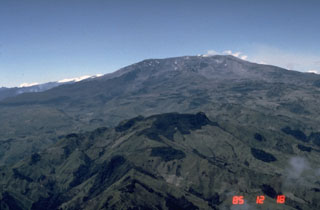
A February 2012 ash explosion of Colombia's Nevado del Ruiz volcano was the first confirmed ash emission in over 20 years. The broad, glacier-capped volcano has an eruption history documented back 8,600 years, and historical observations since 1570. Notably, a large explosion at night in heavy rain on 13 November 1985 generated large lahars that washed down 11 flank valleys, inundating most severely the town of Armero where over 20,000 residents were killed. It remains the second deadliest volcanic eruption of the 20th century after Mt. Pelee in 1902 killed 28,000.
This report summarizes and concludes the February 2012-April 2014 eruption (BGVN 37:08, 39:07), and then describes details of new activity beginning in November 2014, through December 2015. The volcano is monitored by the Servicio Geologico Colombiano (SGC) and aviation reports are provided by the Washington Volcanic Ash Advisory Center (VAAC).
Summary of activity, November 1985-June 2012. After the large explosions and deadly lahars of November 1985, activity at Ruiz continued with intermittent ash emissions and significant seismic activity through July 1991. Seismicity, deformation, and SO2 emissions have been closely monitored since the 1985 eruption. Between 1991 and February 2012 intermittent high-frequency seismic events (earthquake swarms) were recorded, but no ash emissions were observed. In September 2010, seismicity notably increased in frequency and diversity of event type until early 2012 when fresh ashfall was observed. INGEOMINAS (Instituto Colombiano de Geología y Minería, precursor to SGC) also noted an inflationary trend in the geodetic data from October 2010 through 2011.
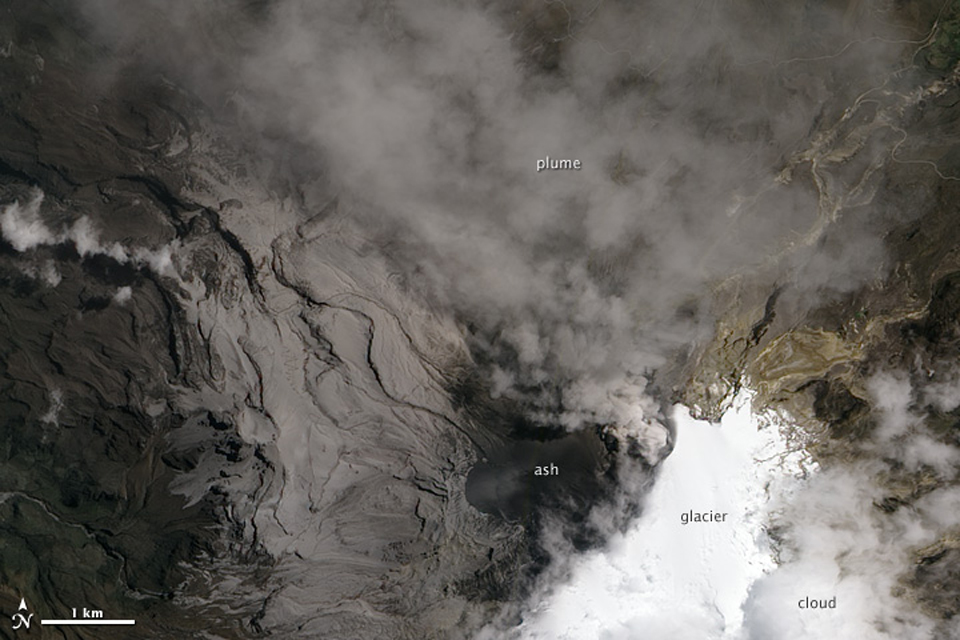
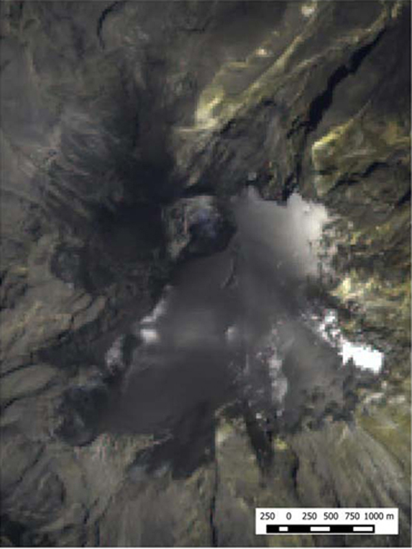
A March 2012 overflight by INGEOMINAS noted minor amounts of ash-covered snow on the E flank, which they surmised came from an explosion on 22 February (BGVN 37:08). During March, long-period seismicity underwent a 20-fold increase. SO2 emissions also dramatically increased between March and June 2012. Several ash emissions from the summit were observed during April-June 2012 (BGVN 37:08). An ash plume that rose to 11 km altitude on 29 May caused ashfall in over 20 communities to the NW and closures at three nearby airports. Widespread ashfall during June covered solar panels on field equipment. An EO-1 satellite image from 6 June 2012 shows a plume and significant ashfall around the summit (figure 71).
Summary of activity, July 2012-December 2015. Explosions and seismic tremor with ash emissions continued during July and August 2012. Ashfall was reported within 30 km on numerous occasions. From September 2012 through early July 2013 minor amounts of ashfall were reported a few times each month, mostly in the immediate vicinity of the volcano. After a larger explosion on 11 July 2013, sparse and intermittent ash emissions were reported between August 2013 and April 2014. Between May and October 2014 there were no reports of ash emissions or thermal anomalies.
A significant increase in seismicity occurred during the second week of November 2014, and ash was seen at the summit during an overflight on 19 November. Ash fell in communities within 30 km several times each month through December 2015. Seismic evidence suggesting possible lava dome extrusion first appeared in August 2015, and stronger signals were recorded on 22 October. Thermal anomalies around the summit crater increased in frequency and magnitude during the last three months of 2015.
Activity during July 2012-October 2014. A large ash plume on 30 June 2012 prompted evacuation warnings to several communities within 30 km and closed three nearby airports for the second time within 30 days. On 2 July the Washington VAAC reported a 7.5-km-wide ash plume at 6.1 km altitude drifting 75 km W (BGVN 37:08). Additional VAAC reports were issued on 8, 9, and 10 July for SO2 emissions containing minor volcanic ash. SGC noted that explosions and ash emissions continued throughout the month in spite of a decrease in seismicity. Ashfall was reported near the volcano, and in municipalities in the departments of Caldas (W) and Risaralda (SW), steadily throughout the month.
Tremors associated with continuing gas and ash emissions occurred throughout August 2012; ash plumes were observed rising 200-800 m above the summit crater. During 3-6 August, gas and ash emissions were seen from Manizales (30 km NW) and Chinchiná (30 km WNW). On 12 August, a gas-and-ash plume observed with a webcam rose 1 km above the crater and drifted W, and ashfall was reported in Brisas (50 km SW). A layer of ash was deposited at the Observatorio Vulcanológico y Sismológico de Manizales (OVSM) on 13 August; they also reported ash emissions associated with seismic signals the next evening. Webcams showed gas-and-ash plumes rising 400 m and drifting W and NW during 15-16 August.
Minor amounts of ashfall were reported by SGC in areas around the volcano each month during September 2012 through 11 July 2013 (table 4), when a larger ash emission occurred. A noted increase in seismicity beginning on 13 April 2013 was also reported by SGC. The ash emission on 11 July was captured by the webcam in the Parque Nacional Natural Los Nevados (PNNN) (figure 72), and fine ash fell in Manizales. The Washington VAAC reported the ash plume at 6.1 km altitude. Multispectral imagery showed the plume extending 55 km NW. After 12 July 2013 there were no further reports from the Washington VAAC until December 2014.
Table 4. Ash emission events at Ruiz during September 2012-July 2013. Data compiled from various sources as shown.
| Date | Event | Details | Source |
| 06 Sep 2012 | Small explosion | Small ash emission. | SGC Weekly Report, 3-9 Sep 2012 |
| 10 Oct 2012 | Ash plume | 7.3 km altitude, drifting 35 km NW. | Washington VAAC |
| 15-16 Nov 2012 | Possible ash emission | Weather clouds prevented observation, faint thermal anomaly detected. | Washington VAAC |
| 10 Dec 2012 | Tremor | Early morning, gas and ash emissions. | SGC Weekly Report, 3-9 Dec (published 11 Dec) 2012 |
| 09 Jan 2013 | Tremor | Ash and gas emission, ashfall reported in the Valle de las Tumbas, W of the summit crater. | SGC Weekly Report, 7-13 Jan 2013 |
| 16 Jan 2013 | Faint ash plume | Drifting NE 50 km; hot spot. | Washington VAAC |
| 11 Feb 2013 | Gas and ash plume | Webcam images and visual observation from Observatorio Manizales, 1,600 m above the crater. | SGC Monthly Technical Report, February 2013 |
| 07-10 Mar 2013 | Continuous tremor | Gas and ash emissions reported by officials from the Parque Nacional Natural los Nevados (PNNN). | SGC Weekly Report, 4-10 Mar 2013. |
| 11-17 Mar 2013 | Continuous tremor | Gas and ash emissions. | SGC Weekly Report, 11-17 Mar 2013 |
| 10-30 Apr 2013 | Constant tremor | Small gas and ash emissions beginning 10 April. | SGC Monthly Technical Report, Apr 2013 |
| 14 Apr 2013 | Gas and ash plume | Webcam image of gas and ash plume rose 630 m and drifted NW. | INGEOMINAS daily report, 14 Apr 2013 |
| 15-21 Apr 2013 | Ashfall confirmed | Ashfall confirmed near Villahermosa (Tolima), 30 km NE. | SGC Weekly Report, 15-21 Apr 2013 |
| 22 and 27 May 2013 | Ash and gas emissions | Confirmed by seismic signals as well as the webcams. | SGC Monthly Report, May 2013 |
| Jun 2013 | Low-energy tremors | Associated with gas and ash emissions, pulses of low energy. | SGC Monthly Technical Report, June 2013 |
| 11 Jul 2013 | Small ash emission | Confirmed by OVSM webcams, and officials at PNNN. Ashfall reported in Valle de las Tumbas and Manizales. | SGC Monthly Technical Report, July 2013; SGC Weekly Report 8-14 July 2013; Washington VAAC |
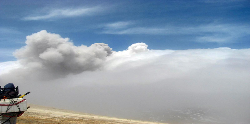 |
Figure 72. Ash emission at Ruiz on 11 July 2013 at 1143. The column of gases and gray ash stands out among the white clouds. Photo by Julián Peña, courtesy of SGC (Informe-Technico, July 2013). |
Evidence for ash emissions between August 2013 and April 2014 is sparse and intermittent. The SGC Monthly reports during this time mention pulses of low-energy tremor associated with emissions of gases, steam, and small amounts of ash every month except November, when they reported only steam and gas, but no specific dates are given. SGC's Technical Information Monthly reports mention occasional grayish coloration, suggesting ash in the gas-and-steam plumes during August-October 2013. Tremors associated with small amounts of ash and grayish coloration in the plumes are again noted from January through April 2014 without describing specific events.
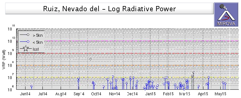
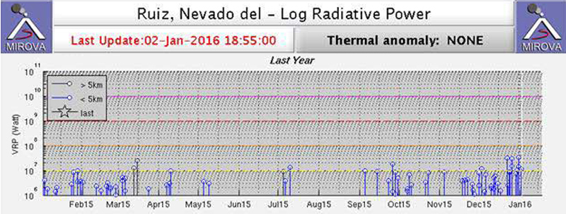
The weekly activity reports issued by SGC make no mention of ash from August through November 2013. They note in weekly reports for 2-8 and 9-15 December that gray emissions possibly associated with ash in plumes of mostly water vapor and gases were observed. During the week of 16-23 December they recorded low-energy tremors associated with the output of small amounts of ash, which were reported in trace quantities in Manizales. In their 31 December 2013-6 January 2014 and 10-16 February 2014 weekly reports they noted the occurrence of tremors associated with ash and gas. There is no mention of ash in their March or April 2014 weekly reports. There is also no mention of ash emission in SGC monthly reports during May-October 2014. The MIROVA thermal anomaly data do show minor thermal anomalies in latest August and more persistent anomalies at the beginning of October 2014 (figure 73) prior to the reports of ash emissions during November.
Activity during November 2014-December 2015. A significant change in seismicity occurred beginning in the second week of November 2014. There was an increase in the number of long-period (LP) earthquakes, pulses of volcanic tremor, and several periods of continuous tremor (lasting for hours or even days) associated with fluid movement, and with emissions of gas and ash (table 5). Several of these periods were preceded by an LP event. The first significant pulse of volcanic tremor began on the evening of 18 November following an LP event and lasted more than 12 hours.
Table 5. Periods of continuous tremor associated with ash emissions at Ruiz during November 2014. Some of the tremor episodes were preceded by long-period (LP) events. Courtesy of SGC (Informe de Actividad, November 2014).
| Date | Time (local) | Duration | LP event (local time) |
| 18 Nov 2014 | 1918 | More than 12 hours | 1918 |
| 20 Nov 2014 | 0224 | More than 20 hours | 0223 |
| 21 Nov 2014 | 0108 | More than 4 hours | -- |
| 28 Nov 2014 | 1310 | More than 4 hours | 1305 |
| 28 Nov 2014 | 1941 | More than 8 hours | -- |
| 29 Nov 2014 | 1307 | More than 48 hours | 1305 |
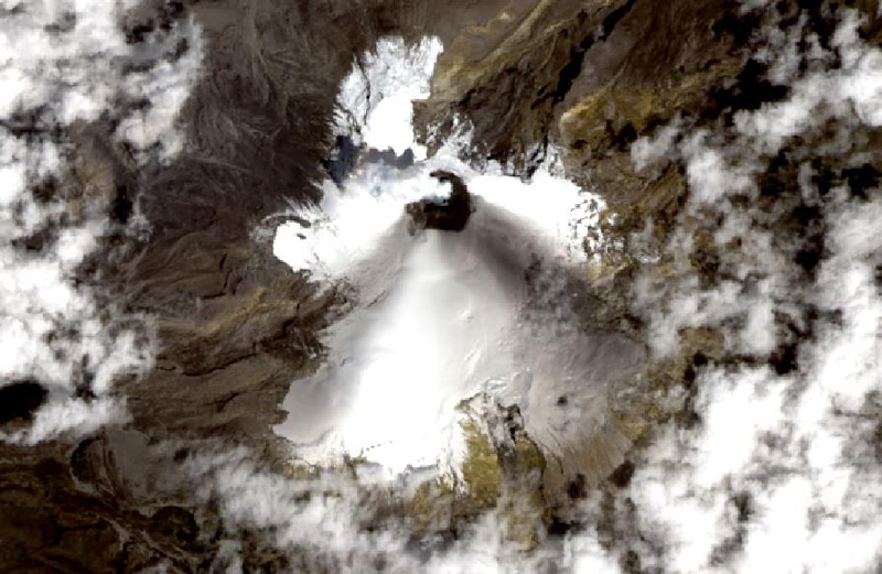
The Unidad Nacional de Gestion de Riesgo de Desastres (UNGRD, National Disaster Risk Management Unit) coordinated an overflight during 19-21 November 2014 and observed fresh ash deposits on the S flank. Ash emissions were also verified in satellite imagery (figure 74) and by reports from nearby communities. The ash dispersed generally SE and SW during 18-21 November. Ash was again observed on the N side of the Arenas crater on 29 November in the early morning after a lengthy period of continuous tremor was recorded the previous day (see table 5).
During the second half of December 2014, SGC reported significant concentrations of ash in the emissions that were associated with continuous tremor episodes. On 15 December seismic signals indicating ash emissions were detected, and then confirmed by a local webcam and nearby residents. The Washington VAAC also noted an ash emission based on a pilot observation extending 16 km S at 7.6 km altitude. The next day they reported a narrow plume of minor volcanic ash extending 22 km SW of the summit at 6.1 km altitude. On 18 and 19 December the Washington VAAC reported ash plumes to altitudes of 7.9 and 9.1 km, respectively, that drifted SSW and dissipated within a few hours. A faint thermal anomaly was also detected. A satellite image taken on 26 December 2014 clearly shows ash deposits in nearly all directions from the Arenas crater (figure 75). Ashfall was reported during this time in the Caldas (W) and Risaralda (SW) departments.
According to the news source Prensa Latina, increased ash emissions at Ruiz prompted closure of the La Nubia airport (22 km NW) on 7 January 2015. On 14 January, the Washington VAAC reported an ash plume visible in satellite imagery extending 16 km SW of the summit at 6.7 km altitude. SGC reported seven episodes of continuous tremor on 4, 7, 14, 24, 26, 28, and 29 January, almost all of which were associated with ash emissions (figures 76). Ashfall was reported several times after these episodes in the Eje Cafetero area to the W of Ruiz.
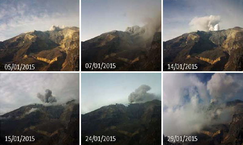 |
Figure 76. Ash emissions on six different dates during January 2015 at Ruiz. Photographs taken by the webcam located in the Azufrado sector (NW). Courtesy of SGC (Informe de Actividad, January 2015). |
Occasional minor ash emissions were reported during February 2015 during periods of continuous tremor, but most of the emissions were steam and gas. On 9 February, ashfall was reported in El Libano (29 km E), El Oso (10 km SE), and Murillo (17 km E). Although seismic tremors were diminished during March from the previous month, emissions associated with these tremors contained gases and minor amounts of ash from 8 March through the end of the month. Ashfall was reported after a tremor in the evening on 8 March by personnel from the Parque Nacional Natural Los Nevados (PNNN), the Observatorio Vulcanológico y Sismológico de Manizales (OVSM), and from the municipalities of Manizales and Villamaria (27 km NW).
An increase in several types of seismicity was observed by SGC during April 2015. Volcanic tremor, associated with gas and ash emissions, were confirmed through photographs taken by the webcams (figure 77), and by officials at PNNN and SGC. Ashfall was reported on 20 April in the municipalities of Manizales and Villamaría. The Washington VAAC reported a small puff of gas and minor amounts of ash visible in satellite imagery on 22 April at 7.3 km altitude drifting W about 40 km before dissipating. The MIROVA signal from the MODIS thermal anomaly data shows persistent thermal activity from late October 2014 through mid-April 2015 (figure 73).
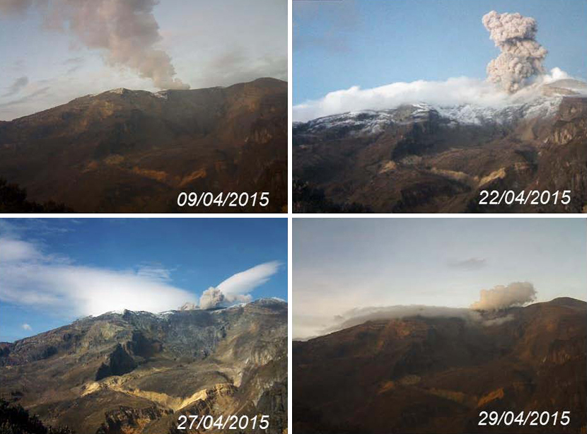 |
Figure 77. Plumes of ash-and-gas from Ruiz during April 2015. Confirmed ash emissions were observed on 9, 22, 27, and 29 April. Courtesy of SGC (Informe de Actividad, April 2015). |
Ash emissions were photographed by the webcams located in the Azufrado and Cerro Guali regions on at least eleven dates during May 2015. The Washington VAAC reported possible emissions on 19 and 26 May, but extensive weather clouds prevented satellite observations. Most of the frequent episodes of volcanic tremor during June were also associated with ash emissions which were photographed at least six times during the month. The Observatory at Manizales reported ash moving WNW on 6 June at about 800 m above the summit; weather clouds obscured satellite observations by the Washington VAAC.
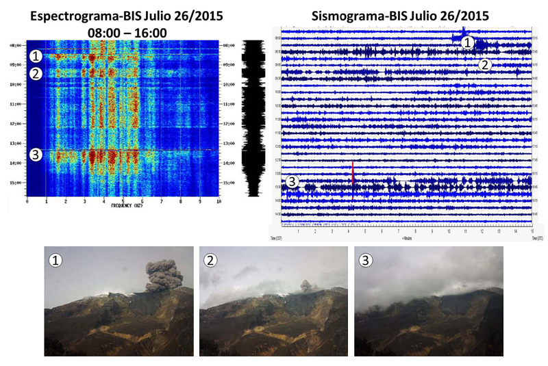
A significant increase in ashfall was reported during July 2015 (figure 78), including in the regions of Caldas, Tolima, and Risaralda, as well as by officials in the Park (PNNN). The Observatory at Manizales (OVSM) reported an ash plume on 6 July at about 7.3 km altitude, but it was not observed in satellite data due to weather. The Washington VAAC noted ash emissions visible in satellite data and the webcam on 13 July, with a plume at 7 km altitude drifting NW a few tens of kilometers before dissipating. OVSM reported plumes at about 6 km moving S and W during 18-20 July. Seismic signals indicating emissions were reported on 23 July and observed in the webcam, according to the Washington VAAC. SGC noted seismic tremors and a plume on the morning of 26 July that rose to 3 km above the summit (8.2 km altitude) (figure 79); near summit-level emissions were also observed via the webcam on 26 and 27 July. Seismic data indicated continued occasional bursts of ash drifting W to WSW during the next few days. Ashfall was reported downwind in the municipalities of Chinchina (33 km NW), Palestina (35 km NW), Santa Rosa de Cabal (33 km W), Dosquebradas (40 km WSW), and Pereira (40 km WSW). A bright thermal anomaly was reported in satellite imagery on 31 July, but no ash was observed.
SGC reported greater instability at Ruiz compared with previous months during August 2015. Seismicity related to fracturing and fluid flow both increased during the month. Energy levels for spasmodic tremor related to gas and ash emissions were also generally higher. The Washington VAAC reported ash visible in satellite imagery on 6 August at 7.3 km altitude moving NW as far as 20 km for about 10 hours before dissipating. They noted another possible plume with minor ash on 12 August at 6.7 km drifting 55 km NW from the summit. Ashfall was reported on 23 August from officials of PNNN and residents of Pereira. A brief emission containing minor ash on 28 August, observed in a webcam, was reported by the Washington VAAC as extending about 35 km W. Ongoing emissions rising a few hundred meters above the summit with occasional small bursts of ash continued for the next two days.
The tremor event on 31 August 2015 was the largest since 18 November 2014; ashfall affected numerous cities and municipalities, including Manizales (30 km NW) (with the largest particle sizes towards the E side of the city), La Linda, La Cabaña (36 km NW), and trace amounts in Santagueda (40 km NW), Arauca (48 km NW), Kilómetro 41, Villamaría (27 km NW), Chinchiná, Palestina, and Neira (36 km NW) (figure 80). A news article reported that the La Nubia airport closed that day due to ash emissions. Most ash emissions during the month affected the regions of Caldas and Risaralda NW of the volcano.
The Washington VAAC issued advisory reports on 3, 12-15, 17, 23-24, 27, and 29-30 September 2015. Most reports were based on observations from the webcams near the volcano and/or seismic activity, but many events were not visible in satellite imagery due to weather clouds. Plume altitudes ranged from 5.5 to 7.9 km. Incandescence observed in a webcam on 4 September was followed by a high-energy tremor. The ash plumes reported by the Washington VAAC on 12 and 13 September rose to 7.9 km and drifted in several directions. Ash was moving to the NW below 5.2 km and extended for over 90 km; between 5.2 and 7.9 km altitude it extended about 80 km SW. Ongoing emissions with small bursts of ash continued through 15 September with a new emission to 7.6 km around 1600 that day.
The OVSM reported a strong seismic signal at 0728 on 17 September, but weather clouds blocked observation from satellite imagery of the potential ash plume. The largest tremor of the month occurred in the afternoon of 18 September and ash emissions were verified in the webcams as well as by SGO officials doing fieldwork in the area; ash emissions were also observed in the webcam on 19 September at 1556. SGO reported a seismic event on 22 September that produced water-vapor, gas, and ash plumes that rose 2 km above the crater and drifted mainly NW. An ash plume was confirmed by the Washington VAAC in a satellite image on 27 September extending about 70 km WNW at 6.1 km altitude. An advisory issued on 29 September noted ash to 8.5 km within 16 km of the summit. SGO noted that the 29 September emissions were observed both E and W of the volcano.
The Washington VAAC confirmed continuous ash emissions on 5 October 2015 at 7 km altitude extending about 25 km W of the summit. A gas, steam, and ash plume rose 1.7 km and drifted NW on 8 October. Another report of volcanic ash early on 9 October was not visible in satellite imagery, although a thermal anomaly persisted and seismicity was elevated. A small ash emission was spotted in imagery data drifting WNW late on 9 October. A gas, steam, and ash plume rose 1.8 km and drifted NW on 17 October. A discrete emission of ash rose to 9.1 km altitude on 22 October and drifted N. SGO reported ash emissions observed in webcams on 26 October, but weather clouds prevented satellite observation by the Washington VAAC. A gas, steam, and ash plume rose 1.7 km and drifted NW on 30 October.
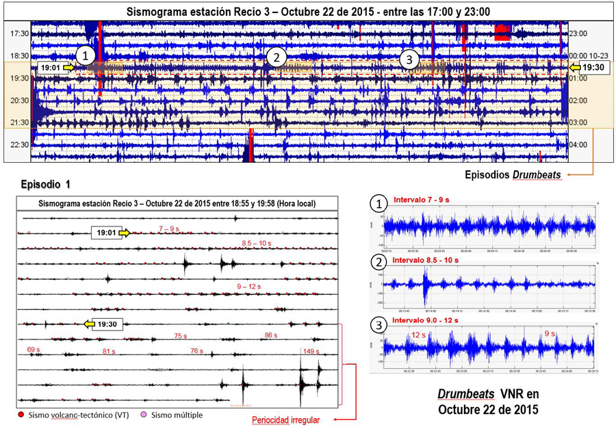
SGC first noticed an unusual pattern of seismicity known as a "drumbeat" signal, for which they issued a special report on 20 August 2015. The "drumbeat" signal is characterized by discrete episodes of short duration (about 30 minutes each) that repeat at regular time intervals and show similar waveforms and energy. They are interpreted by volcanologists to represent phenomena associated with the ascent of high-viscosity magma to the surface and thus are an indicator of near-surface extrusion or dome building. SGC recorded the same signal on 8 September, and then again on 22 October (figure 81). Thermal anomalies near the Arenas crater were observed by SGO on 26, 28, and 30 September, and were again recorded on 7, 9, and 10 October 2015.
Seismic activity decreased slightly during November 2015, but there still were episodes of volcanic tremor associated with gas and ash emissions that were recorded by the webcams and personnel at PNNN. Continuous tremor signal was recorded on 1 and 4 November. The "drumbeat" signal was again briefly recorded on 13 November. Thermal anomalies increased in frequency and were observed on 4, 18, 20, 22, 26, and 27 November. SGC confirmed ash emissions on 5, 10, 14, 27, and 29 November. The Washington VAAC reported an ash plume on 14 November at 6.4 km altitude moving SW. SGC captured images of the ash plume from two different webcams (figure 82).
Thermal alerts captured by the University of Hawai'i's MODVOLC system appeared in December 2015 for the first time in several years. They were recorded on 3, 22, 26, and 31 December. Additionally, the MIROVA thermal anomaly system showed significant increases in anomalies at Ruiz during the last three months of 2015 (figure 83).
Minor episodes of volcanic tremor with ash emissions were reported by SGC during the first two weeks of December 2015. A significant volcanic tremor with ash emissions occurred on 20 December, and ashfall was reported by SGC officials, PNNN personnel, and residents near the volcano and in the city of Manizales. The Washington VAAC noted the ash plume at 6.1 km altitude with 25 km of the summit. A gas, steam and ash plume rose 1.7 km and drifted NW on 28 December.
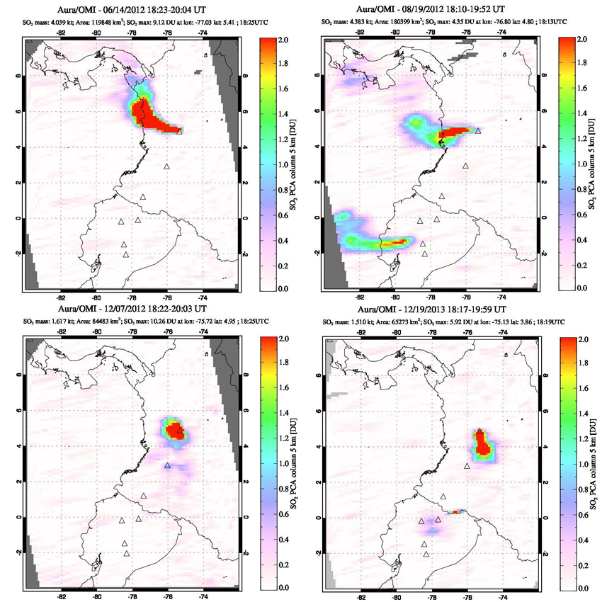
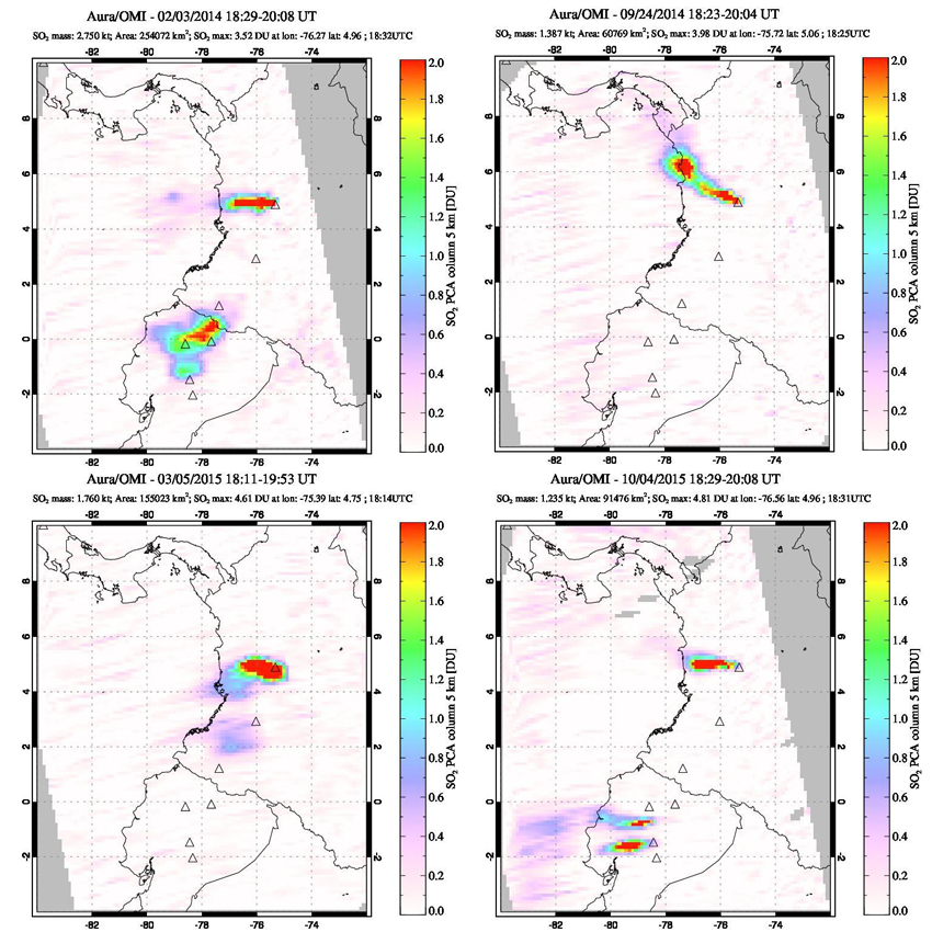
Sulfur Dioxide emissions, June 2012-2015. Persistent, large SO2 plumes were captured from Ruiz many times during June 2012-December 2015 (figure 84 and 85). Every month during this period the OMI (Ozone Measuring Instrument) on the Aura satellite recorded days with SO2 emissions exceeding 2 DU (Dobson Units); many months had more than half of the recording days with values > 2 DU. Dobson Units are the number of molecules in a square centimeter of the atmosphere. If you were to compress all of the sulfur dioxide in a column of the atmosphere into a flat layer at standard temperature and pressure, one Dobson Unit would be 0.01 millimeters thick and contain 0.0285 grams of SO2 per square meter.
Geological Summary. Nevado del Ruiz is a broad, glacier-covered volcano in central Colombia that covers more than 200 km2. Three major edifices, composed of andesitic and dacitic lavas and andesitic pyroclastics, have been constructed since the beginning of the Pleistocene. The modern cone consists of a broad cluster of lava domes built within the caldera of an older edifice. The 1-km-wide, 240-m-deep Arenas crater occupies the summit. The prominent La Olleta pyroclastic cone located on the SW flank may also have been active in historical time. Steep headwalls of massive landslides cut the flanks. Melting of its summit icecap during historical eruptions, which date back to the 16th century, has resulted in devastating lahars, including one in 1985 that was South America's deadliest eruption.
Information Contacts: Servicio Geologico Colombiano (SGC), Observatorio Vulcanologico Y Sismologico Manizales, Diagonal 53 N0. 34 - 53 - Bogotá D.C. Colombia (URL: http://www2.sgc.gov.co/Manizales.aspx); Washington Volcanic Ash Advisory Center (VAAC), Satellite Analysis Branch (SAB), NOAA/NESDIS OSPO, NOAA Science Center Room 401, 5200 Auth Rd, Camp Springs, MD 20746, USA (URL: http://www.ospo.noaa.gov/Products/atmosphere/vaac/, archive at: http://www.ssd.noaa.gov/VAAC/archive.html); Hawai'i Institute of Geophysics and Planetology (HIGP), MODVOLC Thermal Alerts System, School of Ocean and Earth Science and Technology (SOEST), Univ. of Hawai'i, 2525 Correa Road, Honolulu, HI 96822, USA (URL: http://modis.higp.hawaii.edu/); NASA Goddard Space Flight Center (NASA/GSFC), Global Sulfur Dioxide Monitoring Page, Atmospheric Chemistry and Dynamics Laboratory, 8800 Greenbelt Road, Goddard, Maryland, USA (URL: https://so2.gsfc.nasa.gov/); NASA Earth Observatory, EOS Project Science Office, NASA Goddard Space Flight Center, Goddard, Maryland, USA (URL: http://earthobservatory.nasa.gov/); MIROVA (Middle InfraRed Observation of Volcanic Activity), a collaborative project between the Universities of Turin and Florence (Italy) supported by the Centre for Volcanic Risk of the Italian Civil Protection Department (URL: http://www.mirovaweb.it/); Prensa Latina, Agencia Informativa Latinoamericana (URL: http://www.plenglish.com/).

