Report on San Cristobal (Nicaragua) — June 2018
Bulletin of the Global Volcanism Network, vol. 43, no. 6 (June 2018)
Managing Editor: Edward Venzke.
Research and preparation by Paul Berger.
San Cristobal (Nicaragua) Moderate explosion on 22 April 2018
Please cite this report as:
Global Volcanism Program, 2018. Report on San Cristobal (Nicaragua) (Venzke, E., ed.). Bulletin of the Global Volcanism Network, 43:6. Smithsonian Institution. https://doi.org/10.5479/si.GVP.BGVN201806-344020
San Cristobal
Nicaragua
12.702°N, 87.004°W; summit elev. 1745 m
All times are local (unless otherwise noted)
Activity at the San Cristobal volcano complex during 2017 was characterized by numerous weak ash-and-gas explosions, a succession of strong ash-and-gas explosion on 18 August, and thousands of degassing events (BGVN 43:03). This report covers January through July 2018.
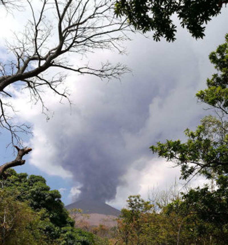
According to the Instituto Nicaragüense de Estudios Territoriales (INETER), at 1320 on 22 April a moderate explosion generated an ash-and-gas plume that rose 500-800 m (figure 38), causing ashfall in the Comarca La Bolsa (8 km SW) and Hacienda Las Rojas (3 km WSW) and Loma Las Brujas (2 km W).
 |
Figure 38. Photo of the gas-and-ash explosion at San Cristobal on 22 April 2018. Courtesy of Fausto Tijerino, INETER (Boletín mensual, Sismos y Volcanes de Nicaragua, Abril, 2018). |
INETER's April bulletin reported that the monthly averages of sulfur dioxide levels at San Cristobal during January through March 2018 ranged from 305-449 metric tons per day. On 22 April, the day of the explosion, levels reached 1903 tons. During the reporting period, MODIS satellite instruments using the MODVOLC algorithm recorded only two questionable thermal anomalies at San Cristobal. The MIROVA (Middle InfraRed Observation of Volcanic Activity) volcano hotspot detection system, also based on analysis of MODIS data, recorded numerous hotspots, but only one within 5 km of the volcano during January through July 2018. The latter one occurred during late March.
Geological Summary. The San Cristóbal volcanic complex, consisting of five principal volcanic edifices, forms the NW end of the Marrabios Range. The symmetrical 1745-m-high youngest cone, named San Cristóbal (also known as El Viejo), is Nicaragua's highest volcano and is capped by a 500 x 600 m wide crater. El Chonco, with several flank lava domes, is located 4 km W of San Cristóbal; it and the eroded Moyotepe volcano, 4 km NE of San Cristóbal, are of Pleistocene age. Volcán Casita, containing an elongated summit crater, lies immediately east of San Cristóbal and was the site of a catastrophic landslide and lahar in 1998. The Plio-Pleistocene La Pelona caldera is located at the eastern end of the complex. Historical eruptions from San Cristóbal, consisting of small-to-moderate explosive activity, have been reported since the 16th century. Some other 16th-century eruptions attributed to Casita volcano are uncertain and may pertain to other Marrabios Range volcanoes.
Information Contacts: Instituto Nicaragüense de Estudios Territoriales (INETER), Apartado Postal 2110, Managua, Nicaragua (URL: http://webserver2.ineter.gob.ni/vol/dep-vol.html); Hawai'i Institute of Geophysics and Planetology (HIGP) - MODVOLC Thermal Alerts System, School of Ocean and Earth Science and Technology (SOEST), Univ. of Hawai'i, 2525 Correa Road, Honolulu, HI 96822, USA (URL: http://modis.higp.hawaii.edu/); MIROVA (Middle InfraRed Observation of Volcanic Activity), a collaborative project between the Universities of Turin and Florence (Italy) supported by the Centre for Volcanic Risk of the Italian Civil Protection Department (URL: http://www.mirovaweb.it/).

