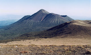
Report on Kirishimayama (Japan) — July 2018
Bulletin of the Global Volcanism Network, vol. 43, no. 7 (July 2018)
Managing Editor: Edward Venzke.
Research and preparation by Paul Berger.
Kirishimayama (Japan) No further activity from Shinmoedake after 27 June 2018
Please cite this report as:
Global Volcanism Program, 2018. Report on Kirishimayama (Japan) (Venzke, E., ed.). Bulletin of the Global Volcanism Network, 43:7. Smithsonian Institution. https://doi.org/10.5479/si.GVP.BGVN201807-282090
Kirishimayama
Japan
31.934°N, 130.862°E; summit elev. 1700 m
All times are local (unless otherwise noted)
Three volcanoes in the Kirishimayama volcanic complex experienced heightened activity during late 2017 and early 2018. There were explosions at Shinmoedake during September-October 2017 and March-May 2018, an explosion at Iwo-yama in April 2018, and heightened seismicity at Ohachi in February 2018 (BGVN 43:06). Activity weakened afterwards, and by the beginning of July the three volcanoes were relatively quiet except for some fumarolic activity and seismic activity. This report documents activity between June and November 2018. Most of the information was provided in Japan Meteorological Agency (JMA) monthly reports.
Activity at Shinmoedake during June 2018. JMA reported that an explosion at 0909 on 22 June generated an ash plume that rose 2.6 km above the crater rim and drifted E. Tephra was ejected 1.1 km away, and shock waves were felt in the Miyazaki region. Minor amounts of ash fell in Kirishima prefecture and Kagoshima prefecture to the S, Miyakonojo city (Miyazaki prefecture) to the E, and Takahara Town. Another explosion at 1534 on 27 June generated a plume that rose 2.2 km above the crater rim.
According to JMA, since the beginning of May the rate of deformation had slowed, and tiltmeter data showed no change. In addition, sulfur dioxide emissions had decreased from 1,000 tons/day on mid-March to 80 tons/day on 1 June. Based on the data, JMA believed the magma supply had declined, decreasing the possibility of an eruption affecting an area outside a radius of 2 km. Thus, on 28 June, JMA lowered the Alert Level from 3 to 2.
Activity at Iwo-yama during June-July 2018. Activity weakened in May, and no volcanic explosions occurred after 27 April. However, active fumarolic activity and ejection of mud continued through November from the vent on the S side. During 23-30 July, white plumes rose 300-500 m above the vent. Also on the S side, the hot lake, which was muddy in May, became transparent in June, but was cloudy again in July. Fumarolic activity also occurred at a vent 500 W of the crater.
Volcanic earthquakes slightly increased in late May. According to measurements by the Global Navigation Satellite System (GNSS), the volcano, which had been contracting, began to expand slowly at the beginning of June. The Alert Level remained at 2.
Geological Summary. Kirishimayama is a large group of more than 20 Quaternary volcanoes located north of Kagoshima Bay. The late-Pleistocene to Holocene dominantly andesitic group consists of stratovolcanoes, pyroclastic cones, maars, and underlying shield volcanoes located over an area of 20 x 30 km. The larger stratovolcanoes are scattered throughout the field, with the centrally located Karakunidake being the highest. Onamiike and Miike, the two largest maars, are located SW of Karakunidake and at its far eastern end, respectively. Holocene eruptions have been concentrated along an E-W line of vents from Miike to Ohachi, and at Shinmoedake to the NE. Frequent small-to-moderate explosive eruptions have been recorded since the 8th century.
Information Contacts: Japan Meteorological Agency (JMA), Otemachi, 1-3-4, Chiyoda-ku Tokyo 100-8122, Japan (URL: http://www.jma.go.jp/jma/indexe.html).

