Report on Telica (Nicaragua) — September 2018
Bulletin of the Global Volcanism Network, vol. 43, no. 9 (September 2018)
Managing Editor: Edward Venzke.
Research and preparation by Paul Berger.
Telica (Nicaragua) Explosions on 21 June and 15 August 2018; local ashfall from June event
Please cite this report as:
Global Volcanism Program, 2018. Report on Telica (Nicaragua) (Venzke, E., ed.). Bulletin of the Global Volcanism Network, 43:9. Smithsonian Institution. https://doi.org/10.5479/si.GVP.BGVN201809-344040
Telica
Nicaragua
12.606°N, 86.84°W; summit elev. 1036 m
All times are local (unless otherwise noted)
The Telica volcano complex, which consists of several cones and craters, has had intermittent eruptions since the Spanish conquest, with emissions of gas and ash. According to The Instituto Nicaragüense de Estudios Territoriales (INETER), the volcano is monitored in real time by a permanent seismic station near the crater. It is also visited several times per year for visual observations, to measure sulfur dioxide emissions, and measure temperatures in the crater and fumaroles near the seismic station. A gas-and-ash explosion occurred in early May 2016 (BGVN 42:01). This report covers activity from September 2016 through June 2018.
INETER reported that local residents heard a small gas explosion on 10 September 2017, and warned the public to stay at least 2 km away from the crater. No ash emissions were reported related to this event.
According to INETER and the Sistema Nacional para la Prevención, Mitigación y Atención de Desastres (SINAPRED), an eruption began at 0708 on 21 June 2018. Explosions produced an ash plume that rose 500 m above the crater and drifted E, S, and SW. Ejected tephra was deposited within a 1-km-radius of the volcano, and ashfall was reported in nearby areas, including La Joya, Las Marías (7 km NNW), Pozo Viejo (10 km NNW), Ojo de Agua, San Lucas (11 km NNW), Las Higueras, Las Grietas (12 km NNW), and Posoltega (16 km WSW).
Another explosion on 15 August 2018 was reported by SINAPRED that generated an ash plume to 200 m above the crater rim.
Seismicity. INETER monthly reports indicated that during September through December 2016, between 3,500 and 3,900 monthly seismic events took place, with the majority having hybrid signatures. During 2017, the monthly number of seismic events ranged from 40,584 (September) to 105,555 (November), of which 50-90% were hybrid events, 9-10% long-period events (but 23 percent in January), and 0-35% multiple events. A few scattered volcanic-tectonic events occurred, and tremor was usually low. Seismic data for January and March consisted of percentages of different earthquake types similar to those during 2017.
About 5% of the monthly seismic signals between April 2017 and January 2018 were doublets, or paired earthquakes with two predominant frequencies. INETER did not mention doublets in their March 2018 report, and did not include seismic data in their February or April 2018 reports.
Sulfur dioxide measurements. According to INETER, during fieldwork on 8 and 11 May 2017 the sulfur dioxide level was measured at 368 ± 194 metric tons/day. This value was lower than those in November 2015 with an average of 765 ± 94 tons/day. On 28 February and 1 March 2018, measurements using the Mobile-DOAS technique found levels greater than 426 tons/day and a minimum value of 152 tons/day, with an average of 260 tons/day, higher than the value measured in September 2017 with 183 tons/day. On 16 and 19 April 2018, the minimum and maximum values were 229 and 567 tons/day, with an average of 353 tons/day.
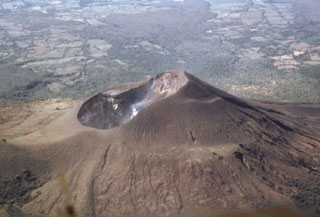
Geological Summary. Telica, one of Nicaragua's most active volcanoes, has erupted frequently since the beginning of the Spanish era. This volcano group consists of several interlocking cones and vents with a general NW alignment. Sixteenth-century eruptions were reported at symmetrical Santa Clara volcano at the SW end of the group. However, its eroded and breached crater has been covered by forests throughout historical time, and these eruptions may have originated from Telica, whose upper slopes in contrast are unvegetated. The steep-sided cone of Telica is truncated by a 700-m-wide double crater; the southern crater, the source of recent eruptions, is 120 m deep. El Liston, immediately E, has several nested craters. The fumaroles and boiling mudpots of Hervideros de San Jacinto, SE of Telica, form a prominent geothermal area frequented by tourists, and geothermal exploration has occurred nearby.
Information Contacts: Instituto Nicaragüense de Estudios Territoriales (INETER), Apartado Postal 2110, Managua, Nicaragua (URL: http://webserver2.ineter.gob.ni/vol/dep-vol.html); Sistema Nacional para la Prevencion, Mitigacion y Atencion de Desastres (SINAPRED), Edificio SINAPRED, Rotonda Comandante Hugo Chávez 50 metros al Norte, frente a la Avenida Bolívar, Managua, Nicaragua (URL: http://www.sinapred.gob.ni/).

