Report on Cleveland (United States) — February 2019
Bulletin of the Global Volcanism Network, vol. 44, no. 2 (February 2019)
Managing Editor: Edward Venzke.
Edited by A. Elizabeth Crafford.
Cleveland (United States) Intermittent dome growth and explosions with small ash plumes, July 2018-January 2019
Please cite this report as:
Global Volcanism Program, 2019. Report on Cleveland (United States) (Crafford, A.E., and Venzke, E., eds.). Bulletin of the Global Volcanism Network, 44:2. Smithsonian Institution. https://doi.org/10.5479/si.GVP.BGVN201902-311240
Cleveland
United States
52.825°N, 169.944°W; summit elev. 1730 m
All times are local (unless otherwise noted)
Dome growth and destruction accompanied by small ash explosions have been typical behavior at Alaska's Cleveland volcano in recent years. Located on Chuginadak Island in the Aleutians, slightly over 1,500 km SW of Anchorage, it has historical activity, including three large (VEI 3) eruptions, recorded back to 1893. The Alaska Volcano Observatory (AVO) and the Anchorage Volcanic Ash Advisory Center (VAAC) are responsible for monitoring activity and notifying air traffic of aviation hazards associated with Cleveland. Its remoteness makes satellite imagery an important source of information for interpreting activity. This report covers continuing thermal and minor explosive activity during July 2018 through January 2019.
After evidence of a small lava dome on the floor of the summit crater appeared in late June 2018, weakly elevated surface temperatures were observed intermittently during July. A small deposit of fresh ejecta was observed in satellite data at the end of July. Weak and moderately elevated surface temperatures were observed during August and into September. A clear satellite image in mid-September confirmed the presence of a growing dome in the summit crater. No seismic or infrasound activity was reported in October or November, and persistent clouds mostly obscured satellite images. Four small explosions were reported during December 2018, two of them produced small ash plumes. A single explosion in early January produced a tephra deposit visible in satellite images, and a new dome was visible growing inside the crater during the middle of the month. Intermittent elevated surface temperatures were observed during the rest of January 2019, but no additional explosions were reported.
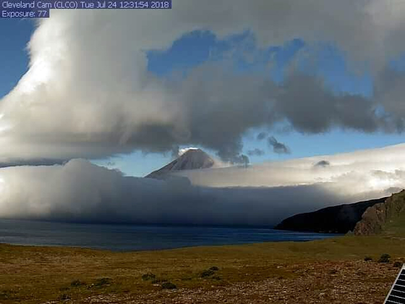
Low levels of unrest continued at Cleveland during July 2018. Elevated surface temperatures were detected through 3 July following the observation of a small lava dome on the floor of the summit crater on 25 June (BGVN 43:07). Weakly elevated surface temperatures were observed in high resolution satellite data on 11 July, and several times during the second half of the month when weather conditions were clear. Field crews working on Chuginadak Island on 19 July 2018 repaired the Cleveland web camera. Steaming at the summit was visible in both web camera and satellite images at times during the last week of July (figure 26). On 24 July, a small deposit of ballistic blocks was observed in satellite imagery within the summit crater and just below the eastern crater rim. These blocks suggested to AVO that minor explosive activity occurred at the summit that was below the detection threshold of the seismic and pressure sensors.
 |
Figure 26. The Cleveland webcam captured a brief clear view of the often-cloudy summit, exhibiting minor steaming, on 24 July 2018. Image courtesy of AVO/USGS. |
No eruptive activity was detected during August. Moderately elevated surface temperatures were observed on 7 August and most days during the second week of the month. Occasional clear web camera views of the summit showed slight steam emissions. The Aviation Color Code was reduced from Orange to Yellow and the Volcano Alert Level to Advisory on 22 August 2018 after several weeks of only elevated surface temperatures in the summit area. Minor explosive activity had last been observed in late July and since that time there had been no evidence of lava extrusion in the summit crater. Elevated surface temperatures continued to be observed, however, during the last two weeks of the month.
Weakly elevated surface temperatures in the summit crater continued to be observed in satellite data during periods of clear weather in the first week of September. A few moderately elevated surface temperatures appeared in the second week, and continued during the third week of September. An unobscured satellite view on 10 September (figure 27) showed the first evidence of an emplaced lava dome within the crater. Temperatures were moderate to weakly elevated throughout the last week of the month. Satellite observations from 20 September suggested that the small collapse crater in the center of the summit dome emplaced over the summer was beginning to inflate, but clear evidence of new lava emplacement was not detected.
No significant activity was detected in seismic or infrasound (pressure) sensor data during October or November 2018. Satellite views of the volcano were obscured by clouds for most of the time; elevated surface temperatures were observed in satellite data a few times in the last few days of October and during the first half of November; there were no observations of activity in mostly cloudy satellite images at the end of November.
Although a few satellite observations of elevated surface temperatures at the summit were made during the first week of December 2018, two small explosions occurred during the second week. The first happened on 8 December at 2355 AKST (0855 UTC on 9 December). The second, which had a higher peak seismic amplitude, occurred on 12 December at 1153 AKST (2053 UTC). No ash cloud was observed after either event, though satellite views were largely obscured by clouds at the time. The color code and Alert Level were raised to Orange/Watch after the second explosion. Elevated surface temperatures continued to be observed in satellite imagery at the volcano's summit during the second week. Another short-lived explosion occurred on 16 December at 0737 AKST (1637 UTC). A small ash cloud drifting NE was observed afterwards in satellite imagery. Elevated surface temperatures appeared following this explosion. Conditions were mostly cloudy for the remainder of December; occasional clear satellite views showed no further temperature anomalies. Local seismic sensors recorded a short-lived explosion at 1817 AKST on 28 December (0317 UTC 29 December). A pilot report indicated an ash plume from the event at 5.2 km altitude moving E.
Satellite images through 2 January 2019 showed that the explosion on 29 December enlarged the diameter of the summit crater by about 25 m and large ballistic blocks impacted the upper edifice N and E of the crater. After 10 days of diminished activity following the sequence of explosions in December, AVO reduced the Aviation Color Code to Yellow and the Volcano Alert Level to Advisory on 7 January 2019. On 9 January at 1015 AKST (1915 UTC) the single local seismic sensor recorded a small, short-lived explosion. A satellite image captured three hours after the event revealed a tephra deposit, a steam plume, and elevated temperature at the summit (figure 28). The explosion was not detected on regional infrasound arrays, nor was a volcanic cloud observed above the meteorological clouds at 3 km altitude.
Satellite data showed that starting around 12 January, a new and growing lava dome was present in the summit crater. It continued to grow slowly through 16 January. This prompted AVO to increase the Color Code to ORANGE and the Alert Level to WATCH on 17 January. Strongly elevated surface temperatures were observed in satellite imagery on 19 and 20 January, reflecting growth of a lava dome. The local infrasound array and a second seismic station near Cleveland that had been offline since 23 September 2018, returned data again briefly on 25 January. Weakly elevated surface temperatures were observed in satellite images during the last week of January. A steam plume was observed at the volcano during clear weather on 27 January. Satellite observations collected after 16 January showed the center of the newly emplaced lava dome slowly subsiding. No explosive activity was detected in regional seismic or infrasound data during the last week of the month.
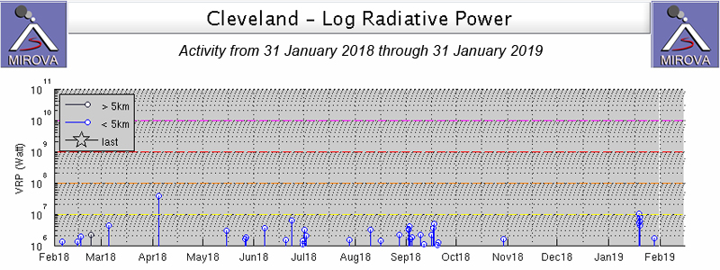
The physically remote location of Cleveland in the Aleutians, and the often-unfavorable meteorological conditions that limit visible satellite observations make the thermal infrared data a valuable component of interpretations of activity. During July 2018 through January 2019 intermittent thermal signals were reported in the MIROVA graph (figure 29). A few of these signals (in September 2018 and January 2019) could be correlated to visual satellite images that confirmed growth of a summit lava dome.
 |
Figure 29. MIROVA data for the year ending on 31 January 2019 shows intermittent thermal anomalies at Cleveland volcano. Courtesy of MIROVA. |
Geological Summary. The beautifully symmetrical Mount Cleveland stratovolcano is situated at the western end of the uninhabited Chuginadak Island. It lies SE across Carlisle Pass strait from Carlisle volcano and NE across Chuginadak Pass strait from Herbert volcano. Joined to the rest of Chuginadak Island by a low isthmus, Cleveland is the highest of the Islands of the Four Mountains group and is one of the most active of the Aleutian Islands. The native name, Chuginadak, refers to the Aleut goddess of fire, who was thought to reside on the volcano. Numerous large lava flows descend the steep-sided flanks. It is possible that some 18th-to-19th century eruptions attributed to Carlisle should be ascribed to Cleveland (Miller et al., 1998). In 1944 it produced the only known fatality from an Aleutian eruption. Recent eruptions have been characterized by short-lived explosive ash emissions, at times accompanied by lava fountaining and lava flows down the flanks.
Information Contacts: Alaska Volcano Observatory (AVO), a cooperative program of a) U.S. Geological Survey (USGS), 4200 University Drive, Anchorage, AK 99508-4667 USA (URL: https://avo.alaska.edu/), b) Geophysical Institute, University of Alaska, PO Box 757320, Fairbanks, AK 99775-7320, USA, and c) Alaska Division of Geological & Geophysical Surveys (ADGGS), 794 University Ave., Suite 200, Fairbanks, AK 99709, USA (URL: http://dggs.alaska.gov/); Sentinel Hub Playground (URL: https://www.sentinel-hub.com/explore/sentinel-playground); MIROVA (Middle InfraRed Observation of Volcanic Activity), a collaborative project between the Universities of Turin and Florence (Italy) supported by the Centre for Volcanic Risk of the Italian Civil Protection Department (URL: http://www.mirovaweb.it/).


