Report on Sinabung (Indonesia) — March 2021
Bulletin of the Global Volcanism Network, vol. 46, no. 3 (March 2021)
Managing Editor: Edward Venzke.
Edited by A. Elizabeth Crafford.
Sinabung (Indonesia) Block avalanches, pyroclastic flows, and ash explosions continue through February 2021
Please cite this report as:
Global Volcanism Program, 2021. Report on Sinabung (Indonesia) (Crafford, A.E., and Venzke, E., eds.). Bulletin of the Global Volcanism Network, 46:3. Smithsonian Institution. https://doi.org/10.5479/si.GVP.BGVN202103-261080
Sinabung
Indonesia
3.17°N, 98.392°E; summit elev. 2460 m
All times are local (unless otherwise noted)
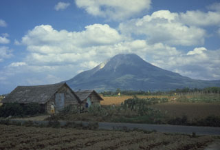
Indonesia’s Sinabung volcano in north Sumatra had its first confirmed Holocene eruption during August and September 2010. It remained quiet until September 2013 when a new eruptive phase began that continued through mid-2018. Dome growth and destruction resulted in block avalanches, multiple explosions with ash plumes, and deadly pyroclastic flows during the period. After a pause in activity from September 2018 through April 2019, explosions resumed during May and June 2019. Dome growth began again with an explosion on 8 August 2020, and similar activity continued through October 2020. This report covers ongoing activity from November 2020 through February 2021 with information provided by Pusat Vulkanologi dan Mitigasi Bencana Geologi (PVMBG), referred to by some agencies as CVGHM or the Indonesian Center of Volcanology and Geological Hazard Mitigation, and the Darwin Volcanic Ash Advisory Centre (VAAC). Additional information comes from satellite instruments and local news reports.
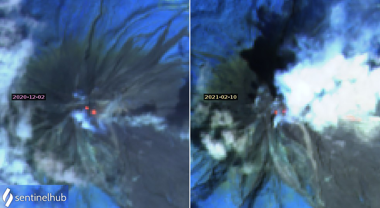
Activity at Sinabung during November 2020-February 2021 was characterized by tens of daily rock avalanches, periodic pyroclastic flows, and ash-bearing explosions. The rock avalanches traveled up to 1,000 m down the E and SE flanks. The pyroclastic flows also traveled down the E and SE flanks, and the largest reached 2.5 km from the summit. Periodic explosions produced ash plumes that rose up to 2 km above the summit and drifted in multiple directions. Although cloudy much of the time, intermittent satellite images showing two thermal anomalies at the summit suggested that the dome remained active (figure 85).
White steam emissions rose 50-500 m above the summit of Sinabung during most days in November 2020. Block avalanches were frequent during the first half of the month, traveling 200-1,000 m down the S and SE flanks. The Darwin VAAC reported small ash plumes from block avalanches on 1 and 2 November that rose to 3 km altitude and quickly dissipated. Clouds prevented observations during the last week of the month, but tens of seismic events interpreted by PVMBG as block avalanches were detected. Pyroclastic flows were either observed visually or measured seismically on 2-7, 10, 12, 16, 18 and 19 November (figure 86). They most often occurred on the E or SE flanks and traveled 1,500-2,500 m. Seismic signals indicating lahars were recorded on 26, 27, and 30 November.
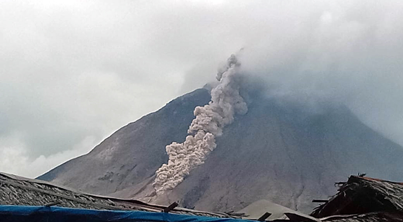 |
Figure 86. A pyroclastic flow descended the S flank of Sinabung on 7 November 2020. Courtesy of Rizal. |
Nine explosions with ash plumes were reported during November 2020. On 2 November a gray ash plume rose 1,500 m above the summit, to about 3.9 km altitude, and drifted E. The next day the Darwin VAAC reported an explosion to 3.7 km altitude that drifted E. An ash explosion on 4 November was recorded seismically for 117 seconds but was not seen due to fog. An explosion on 10 November produced an ash plume that rose 2 km above the summit and drifted E, along with pyroclastic flows that traveled 1,500-2,500 m down the E and SE flanks. On 18 November an explosion created an ash plume that rose to 3.7 km altitude and drifted SW; it was measured seismically as a continuous volcanic tremor that lasted for 160 seconds. Seismic activity confirmed an explosion on 21 November, but meteoric clouds obscured observations of ash. An ash plume drifting SW at 3 km altitude, about 500 m above the summit, was reported on 25 November. On 29 November an explosion produced an ash plume to the same altitude that drifted E (figure 87). The next day seismic activity indicated another explosion, but it was not observed due to cloudy weather.
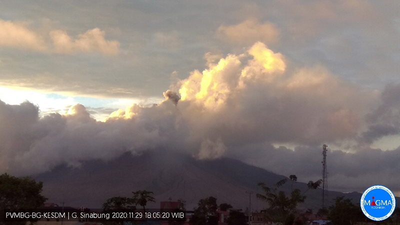 |
Figure 87. An ash plume at Sinabung rose to 3 km altitude and drifted E on 29 November 2020. Courtesy of PVMBG and MAGMA Indonesia. |
Explosive activity decreased during December 2020. Steam plumes rose 50-500 m and tens of rock avalanches were recorded seismically every day. On 6 December block avalanches rolled 300-500 m down the E and SE flanks; they traveled 500-1,000 m down the SE flank on 8 December. During 12-14 December they traveled 1,000-1,500 m down the E and S flanks. On 30 and 31 December they were seen moving 500-1,000 m down the same flanks. Lahars were measured seismically on 4 and 5 December with no reports of damage.
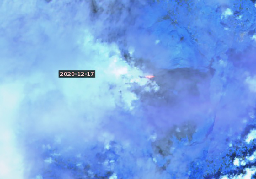
An explosion on 2 December produced an ash plume that rose about 500 m above the summit and drifted ESE. Clouds and rain prevented views of the summit on 5 December, but the seismogram recorded an explosive event that lasted for 168 seconds (figure 88). The Darwin VAAC reported an ash plume moving ESE at 3 km altitude on 13 December. Sentinel-2 satellite imagery captured a thermal anomaly on the E flank on 17 December that was likely from a pyroclastic flow (figure 89). Two explosions were recorded each day on 28 and 29 December. On the first day the ash plume from the first explosion rose to 500 m and drifted S. The second explosion was not observed due to weather, but a thermal anomaly was intermittently visible. The explosions on 29 December were only recorded seismically, as was one explosion on 30 December.
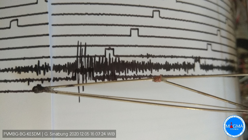 |
Figure 88. The KESDM seismogram at Sinabung recorded an explosive event on 5 December 2020 that lasted for 168 seconds. Courtesy of PVMBG and MAGMA Indonesia. |
Tens of daily rock avalanches continued to be recorded during January 2021, although most were not observed. During 2-5 January they traveled 500-1,200 m down the E and SE flanks, and on 14 January they fell 700-1,000 m down the SE flank. The number of explosions with ash plumes increased significantly from December. On 3 January two explosions were recorded seismically; an ash plume from the first rose 1,000 m above the summit and drifted NW in the morning. A few hours later a second explosion was recorded but not observed due to clouds. Three explosions were recorded each day on 4 and 5 January. The first on 4 January produced a 700-m-high ash plume, the second and third sent ash 1,000 m above the summit to the W and NW (figure 90). The next day, the first explosion sent an ash plume 800 m above the summit that drifted E and SE; the other two were recorded seismically but not observed due to weather. One or two explosions were recorded daily during 6-10 January; most were obscured by clouds. One of the explosions on 8 January produced an ash plume that rose to 700 m and drifted N, and the explosion on 9 January rose to 1,000 m and drifted N and NE. Two explosions were recorded on 12 January, and two or three explosions were reported daily during 16-18 January. Explosions were also recorded on 20-21, 23, 25-27, and 29 January. The three ash plumes on 17 January all rose 500 m above the summit and drifted E, NE, or SE; the plumes on 21 and 27 January rose 500 m and drifted E and SE.
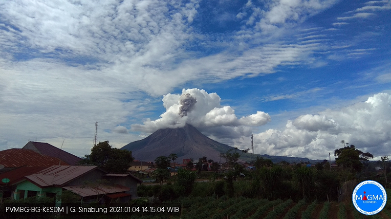 |
Figure 90. An explosion at Sinabung on 4 January 2021 produced an ash emission that rose 1,000 m above the summit and drifted W and NW. Courtesy of PVMBG and MAGMA Indonesia. |
Steam emissions rose 50-700 m above the summit throughout February 2021. Over 100 seismic events from rock avalanches were reported daily; on 6 February a maximum of 231 events were recorded. Numerous explosions, many with pyroclastic flows, were only detected seismically on 5-12, 14, 17, 22, 25, and 28 February. On 6 February the Darwin VAAC reported a continuous ash eruption identified in satellite imagery at 3.1 km altitude drifting NW. PVMBG also reported a pyroclastic flow that traveled 2,500 m down the S flank that day. The Antara News Agency reported an ash plume rising 1,000 m above the summit from a pyroclastic flow and drifting E, SE, and S on 7 February, and another pyroclastic flow on 9 February that traveled 1,000 m down the SE flank (figure 91). Cloudy weather obscured views on most days, but during 12-14 February blocks traveled 500-1,500 m down the S, SE, and E flanks.
 |
Figure 91. A pyroclastic flow traveled 1,000 m down the SE flank of Sinabung on 9 February 2021. Courtesy of Anadolu Agency. |
The Darwin VAAC received a report on 10 February of an ash plume at 4.6 km altitude moving E; it was not identifiable in satellite imagery due to meteoric clouds. Two pyroclastic flows on 12 February moved as far as 2,000 m down the E and SE flanks. On 17 February an ash plume rose 1,000 m above the summit and drifted S and W and a pyroclastic flow was reported. A lahar was reported on 21 February. A pyroclastic flow on 22 February traveled 2,000 m down the E and SE flanks. The ash plume from the 25 February event rose to 1,500 m above the summit to about 3.9 km altitude and drifted E and SE (figure 92) and was accompanied by four pyroclastic flows that traveled 500-1,000 m down the E and SE flanks. A discrete ash plume was reported by the Darwin VAAC on 28 February that rose to 3.1 km altitude and drifted SW, dissipating withing six hours. Pyroclastic flow were observed that day moving 1,000-1,250 m down the S, SE, and E flanks.
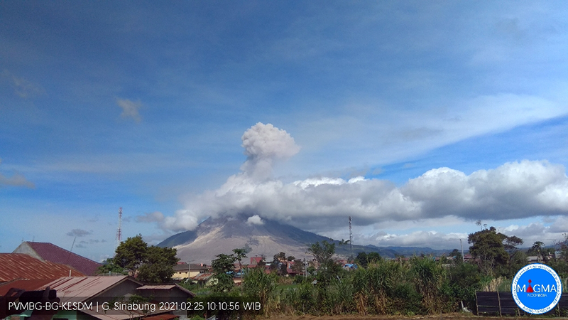 |
Figure 92. The ash plume at Sinabung from a 25 February 2021 explosion rose to 1,500 m above the summit and drifted E and SE. Courtesy of PVMBG and MAGMA Indonesia. |
Geological Summary. Gunung Sinabung is a Pleistocene-to-Holocene stratovolcano with many lava flows on its flanks. The migration of summit vents along a N-S line gives the summit crater complex an elongated form. The youngest crater of this conical andesitic-to-dacitic edifice is at the southern end of the four overlapping summit craters. The youngest deposit is a SE-flank pyroclastic flow 14C dated by Hendrasto et al. (2012) at 740-880 CE. An unconfirmed eruption was noted in 1881, and solfataric activity was seen at the summit and upper flanks in 1912. No confirmed historical eruptions were recorded prior to explosive eruptions during August-September 2010 that produced ash plumes to 5 km above the summit.
Information Contacts: Pusat Vulkanologi dan Mitigasi Bencana Geologi (PVMBG, also known as Indonesian Center for Volcanology and Geological Hazard Mitigation, CVGHM), Jalan Diponegoro 57, Bandung 40122, Indonesia (URL: http://www.vsi.esdm.go.id/); MAGMA Indonesia, Kementerian Energi dan Sumber Daya Mineral (URL: https://magma.esdm.go.id/v1); Darwin Volcanic Ash Advisory Centre (VAAC), Bureau of Meteorology, Northern Territory Regional Office, PO Box 40050, Casuarina, NT 0811, Australia (URL: http://www.bom.gov.au/info/vaac/); Sentinel Hub Playground (URL: https://www.sentinel-hub.com/explore/sentinel-playground); Rizal (URL: https://twitter.com/Rizal06691023/status/1324972883634917376); Antara News Agency (URL: https://www.antaranews.com/berita/1986704/guguran-abu-gunung-sinabung-teramati-setinggi-1000-meter); Anadolu Agency (URL: https://www.aa.com.tr/ba/svijet/indonezija-u-vulkanu-sinabung-odjeknula-eksplozija/2138389).

