Report on Telica (Nicaragua) — March 2021
Bulletin of the Global Volcanism Network, vol. 46, no. 3 (March 2021)
Managing Editor: Edward Venzke.
Research and preparation by Paul Berger.
Telica (Nicaragua) Numerous explosions and ash plumes during late November-early December 2020
Please cite this report as:
Global Volcanism Program, 2021. Report on Telica (Nicaragua) (Venzke, E., ed.). Bulletin of the Global Volcanism Network, 46:3. Smithsonian Institution. https://doi.org/10.5479/si.GVP.BGVN202103-344040
Telica
Nicaragua
12.606°N, 86.84°W; summit elev. 1036 m
All times are local (unless otherwise noted)
During January-October 2020, activity at Telica consisted of frequent seismicity, fumarolic emissions, and beginning in July, explosions that generated gas-and-ash plumes (BGVN 45:11). The following report describes activity between November 2020 and February 2021 using monthly and special bulletins published by the Instituto Nicaragüense de Estudios Territoriales (INETER) and satellite images.
Following some small ash explosions in late October, activity decreased in November 2020. INETER scientists visiting the volcano on 24 November observed small pulses of gas and ash originating from the SW walls and flanks, and heard jet sounds inside the crater. The team also noted abundant gas emissions on the N and NW walls and subsidence inside the crater.
A new series of ash explosions began at 0538 on 30 November (figure 52). Similar activity later that morning ejected incandescent ballistics and generated a small gas-and-ash plume (figure 53). Almost continuous explosions for more than three days produced gas-and-ash plumes that rose 50-400 m above the crater rim, depositing most of the ash on the SW slope. The explosive activity on 2 December was visible in satellite imagery (figure 54), and ash plumes the next day reached the ocean (figure 55). After more than three days of almost continuous explosions, explosions became sporadic until 1450 on 8 December. A total of 1,315 small explosions were recorded between 30 November and 8 December. Ashfall during this period was reported in communities to the SW, including Zarandaj (6 km WSW), Cristo Rey (6 km W), Las Colinas (7 km WSW), Garrobo Empinado (8 km SSW), El Panal (9 km SSW), Canta Rana (10 km SW), Ceibo Chachagua (10 km SW), Las Mercedes (10 km SW), Punta Arena (10 km SW), La Virgen (12 km WSW), Filiberto Morales (15 km WSW), Los Cocos (9 km SSW), Verónica Lacayo (10 km SW), and Nuevo Belén.
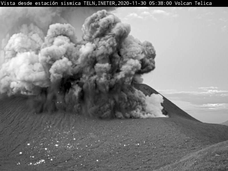 |
Figure 52. Webcam photo of an explosion at Telica at 0538 on 30 November 2020. This event was the first in a series of explosions that continued until 8 December. Courtesy of INETER. |
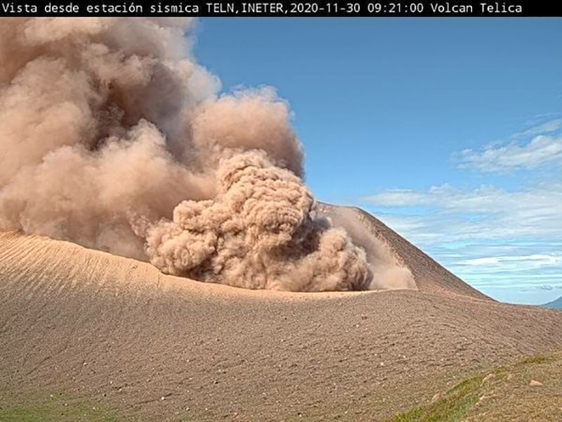 |
Figure 53. Webcam photo of an explosion at Telica at 0921 on 30 November 2020 that generated a dense brown ash plume. Courtesy of INETER. |
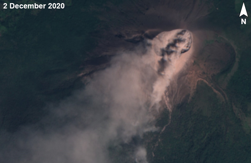 |
Figure 54. Sentinel-2 images of Telica on 2 December 2020 in natural color (bands 4, 3, 2) showing a brown gas-and-ash plume streaming SW. Courtesy of Sentinel Hub Playground. |
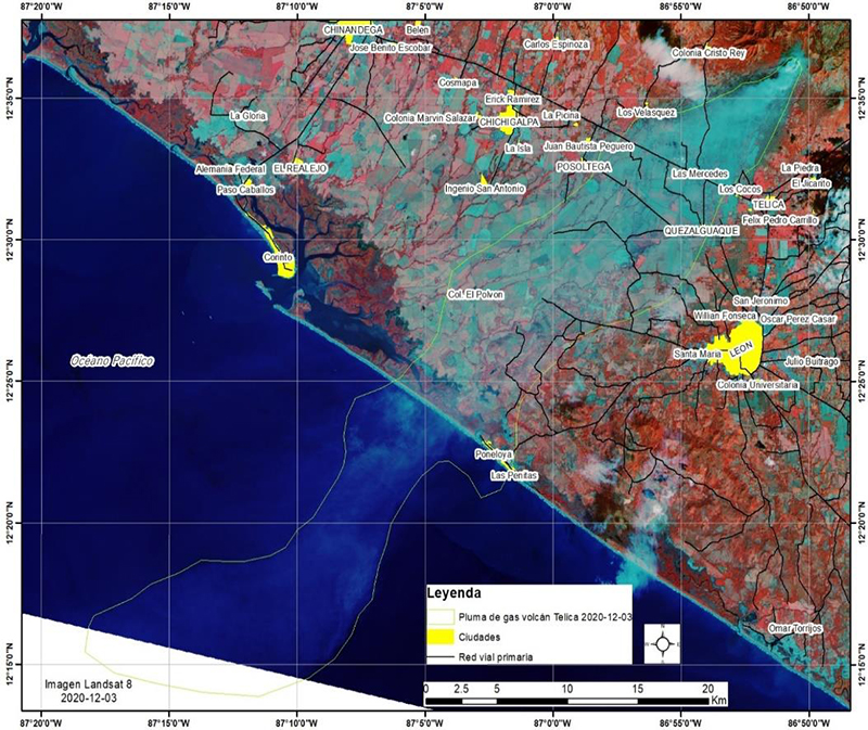 |
Figure 55. Landsat 8 false-color image (bands B4, B7, B1) of a gas plume (light blue) from Telica extending SW over the Pacific Ocean on 3 December 2020. Courtesy of INETER. |
Thermal anomalies seen in Sentinel-2 satellite images were identified again starting on 14 December 2020, for the first time since 10 September. The hotspot in the eastern part of the crater was detected intermittently through 22 February 2021.
SO2 emissions measured by the Mobile-DOAS technique using 5-7 transects, averaged 99 metric tons/day for November and 821 metric tons/day for December. These values were outside the normal range and represented among the lowest and highest averages, respectively, since at least 2009. SO2 emissions averaged 129 metric tons/day during January. Small landslides were heard in February, and weak degassing was evident.
According to INETER, about 907,863 seismic events were recorded during 2020, of which 51,275 were long-period (LP) earthquakes; the source of which was 6-10 km deep. In December alone, seismicity was dominated by volcano-tectonic (VT) earthquakes, of which 262,549 were counted. Tremor remained between 20-50 RSAM units. Seismicity continued in early 2021, though INETER did not report any explosive activity. In January 2021 about 140,000 seismic events occurred, of which 24,652 were LP earthquakes. In February about 86,243 seismic events occurred, of which 1,725 were LP earthquakes, 431 were VT earthquakes, and 15,093 were hybrid earthquakes. During both months, tremor remained between 20-50 RSAM units.
During a field visit on 19 January 2021, INETER observed that the crater had increased in diameter to 20 m and in depth to 5 m. The main crater displayed weak gas emissions. During the visit, temperatures of the four fumaroles on the eastern rim were 55-57°C, somewhat lower than the previous three months and significantly lower than during February-July 2020. Temperatures during a visit on 11 February were even lower.
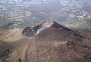
Geological Summary. Telica, one of Nicaragua's most active volcanoes, has erupted frequently since the beginning of the Spanish era. This volcano group consists of several interlocking cones and vents with a general NW alignment. Sixteenth-century eruptions were reported at symmetrical Santa Clara volcano at the SW end of the group. However, its eroded and breached crater has been covered by forests throughout historical time, and these eruptions may have originated from Telica, whose upper slopes in contrast are unvegetated. The steep-sided cone of Telica is truncated by a 700-m-wide double crater; the southern crater, the source of recent eruptions, is 120 m deep. El Liston, immediately E, has several nested craters. The fumaroles and boiling mudpots of Hervideros de San Jacinto, SE of Telica, form a prominent geothermal area frequented by tourists, and geothermal exploration has occurred nearby.
Information Contacts: Instituto Nicaragüense de Estudios Territoriales (INETER), Apartado Postal 2110, Managua, Nicaragua (URL: http://www.ineter.gob.ni/); Sentinel Hub Playground (URL: https://www.sentinel-hub.com/explore/sentinel-playground).

