Report on Hunga Tonga-Hunga Ha'apai (Tonga) — March 2022
Bulletin of the Global Volcanism Network, vol. 47, no. 3 (March 2022)
Managing Editor: Edward Venzke.
Edited by Kadie L. Bennis.
Hunga Tonga-Hunga Ha'apai (Tonga) Surtseyan explosions with eruption plumes during 14-15 January 2022
Please cite this report as:
Global Volcanism Program, 2022. Report on Hunga Tonga-Hunga Ha'apai (Tonga) (Bennis, K.L., and Venzke, E., eds.). Bulletin of the Global Volcanism Network, 47:3. Smithsonian Institution. https://doi.org/10.5479/si.GVP.BGVN202203-243040
Hunga Tonga-Hunga Ha'apai
Tonga
20.5532°S, 175.3841°W; summit elev. 114 m
All times are local (unless otherwise noted)
The Hunga Tonga-Hunga Ha’apai volcano includes the small islands of Hunga Tonga and Hunga Ha’apai along with shallow reefs along the caldera rim of a much larger submarine edifice in the western South Pacific Ocean (see figure 25; BGVN 47:02), west of the main inhabited islands in the Kingdom of Tonga. It is one of 12 confirmed submarine volcanoes along the Tofua Arc, a segment of the larger Tonga-Kermadec volcanic arc. The Tonga-Kermadec arc formed as a result of subduction of the Pacific Plate beneath the Indo-Australian Plate. The capital city of Tonga, Nuku’alofa, is located 65 km S on the island of Tongatapu. New Zealand lies 2,000 km S, and Australia is over 3,000 km SW.
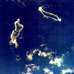
The first recorded eruption at this site occurred in 1912, followed by an eruption in 1937, and then S of the islands in 1988. In 2009 a short eruption increased the land area at Hunga Ha’apai; around this time the two islands were each about 2 km long (BGVN 34:03). During December 2014 through January 2015 eruptive activity added land between the islands, creating the merged Hunga Tonga-Hunga Ha’apai island (BGVN 40:01). Major Surtseyan explosions and eruption plumes were detected beginning in late December 2021, which initially reshaped the central part of the combined island (BGVN 47:02) before stronger activity on 14 January 2022 removed most of the 2014-2015 material. The next day, 15 January, an even larger eruption generated a plume that reached at least 20 km altitude, caused a tsunami across the Pacific Ocean, and triggered shock waves through the atmosphere; only small remnant of the islands remained visible above the ocean surface. This report will update details of the large 14-15 January 2022 events using information primarily from the Tonga Geological Services (TGS), Tongan and New Zealand news outlets, the Wellington and Darwin Volcanic Ash Advisory Centers (VAAC), and various satellite data.
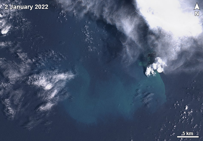
Activity during 1-13 January 2022. According to observations of satellite images, little eruptive activity was detected during 1-2 January. On 2 January a Sentinel-2 natural color image showed green-yellow discolored water in the area west of the volcano, accompanied by white gas-and-steam emissions drifting NE on the SW end of the westernmost island (figure 44). Pumice rafts roughly 10 m wide were also visible in Sentinel-2 satellite imagery, drifting about 100 km W of the volcano on 2 January (see figure 41; BGVN 47:02). The surface area of the island had grown from approximately 2 km2 on 10 December 2021 to 3.6 km2 on 2 January 2022. The vent was estimated to be at 90 m elevation and the base of the active cone had grown from 500 to 1,700 m wide.
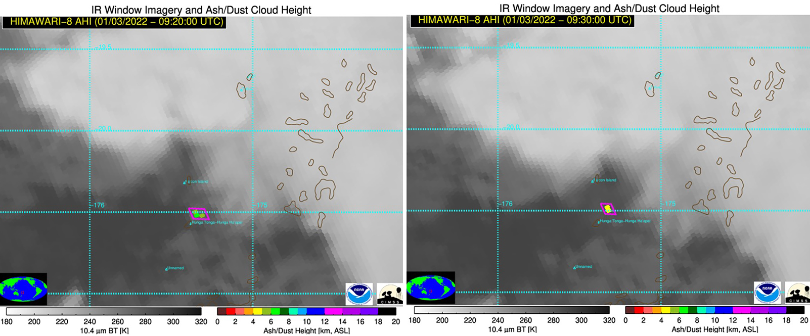
A small ash plume was detected during 2220-2230 on 3 January that rose to 6-7 km altitude and drifted 5-10 km NE, according to TGS (figure 45). At 2230 the plume decreased in altitude to 5 km. During 3-4 January a cyclone passed through the area, obscuring views of the volcano. A minor ash plume was again detected between 0000 and 0010 on 5 January, which rose to 8 km altitude and drifted 15 km NE; by 0010 the plume had drifted 18 km ENE. Some pumice had washed up on the northwestern beaches of Tongatapu Island on 5 January (see figure 42; BGVN 47:02) and a sulfurous odor was reported on the Nuku’alofa waterfront on 6 January.
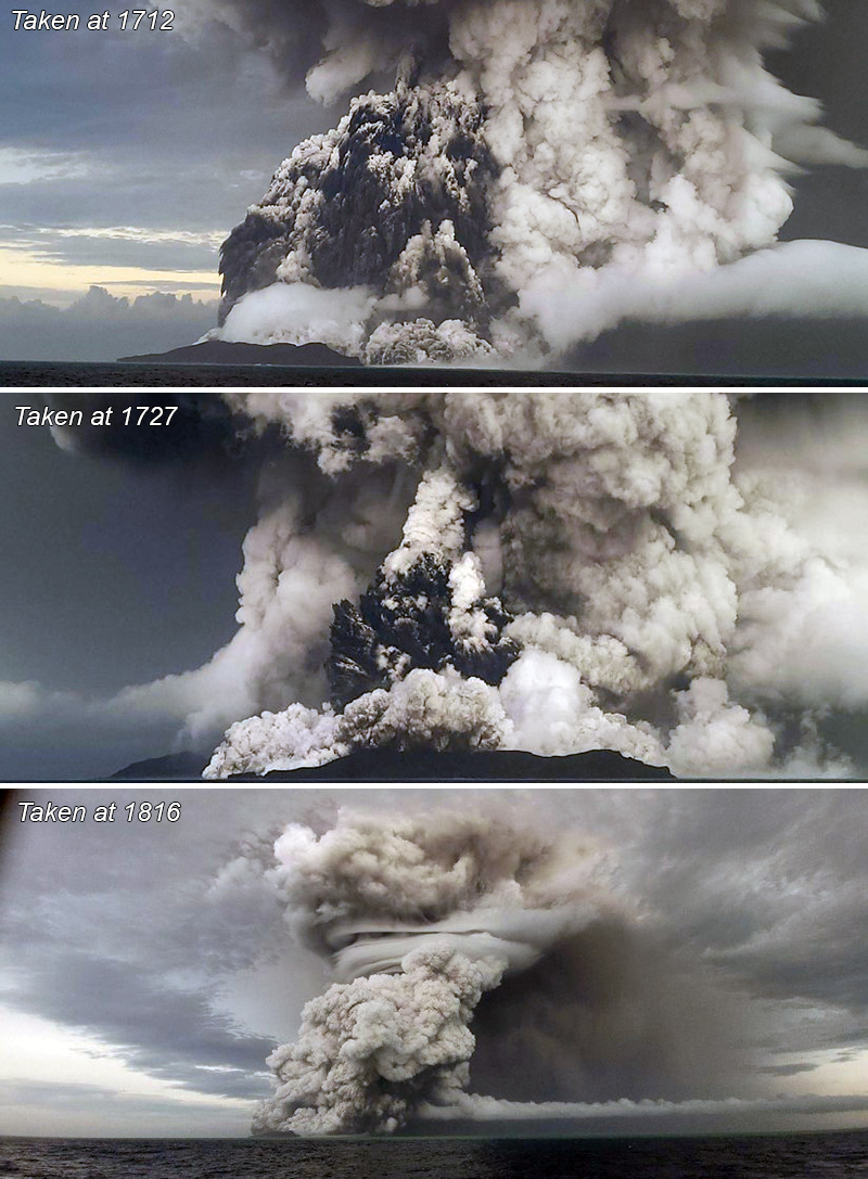
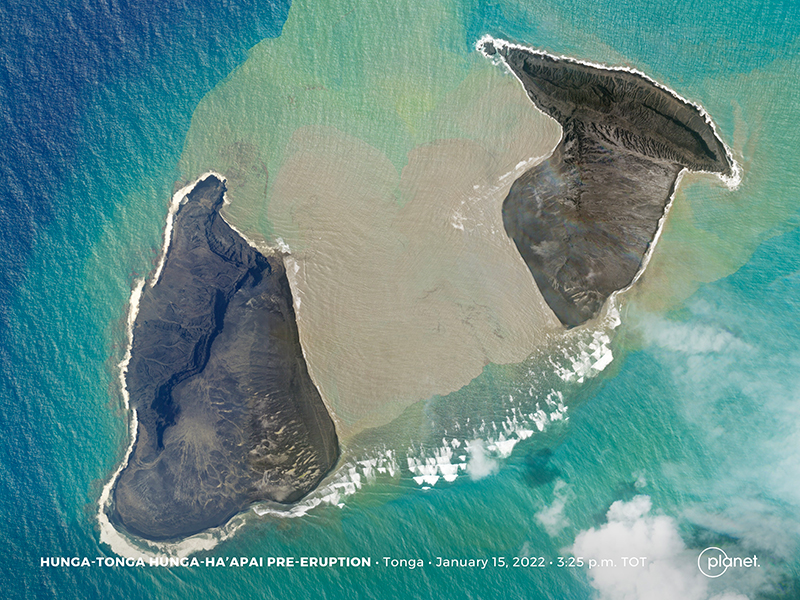
Activity during 14 January 2022. A sub-aerial eruption that began at 0420 on 14 January generated a mushroom-shaped eruption plume consisting of gas-and-steam and ash which was 5 km wide at the base and rose to the stratosphere, 18-20 km altitude, according to TGS (figure 46). The plume expanded radially to 240-260 km diameter and extended over Tongatapu (70 km S), ‘Eua (106 km SSE), Ha’apai (130 km NE), and Vava’u (270 km NNE). Geologists on a boat observed Surtseyan pulses ejecting dark, dense material into the air and pyroclastic flows expanding over the ocean around 1700-1830 (figure 47). The activity removed approximately the middle third of the island that had been enlarged over the previous weeks, according to analysis of a Planet Labs satellite image acquired at 1525 on 15 January (figure 48).
A national tsunami warning was issued at 1112 due to abnormal swirling water off the coast of Nuku’alofa, according to a Matangitonga news article. The Tonga Meteorological Services (TMS) also issued tsunami warnings for areas including ‘otu Mu’omu’a in Ha’apai (Nomuka, Mango, Fonoifua), ‘Atataa, ‘Eueiki, and Tongatapu mo ‘Eua. Fluctuating tsunami waves were recorded off the coast of Tongatapu throughout the day; waves reached 200 m inland and rose as high as 15 m in elevation on the Good Samaritan Beach, according to TGS. The highest tsunami wave was recorded around 1800, measuring 30 cm, according to the Nuku’alofa tidal gauge.
The eruption on 14 January continued for more than 12 hours, with the plume reaching 20 km altitude, based on data from HIMAWARI-8 AHI satellite imagery captured between 1410 and 2330. Ashfall was reported on the Mango and Fonoi (75 km ENE) islands of Ha’apai. The eruption plume also contained an estimated sulfur dioxide mass of 0.05 Tg (50 kilotons), based on satellite data. As a result, the smell of sulfur was reported over Tongatapu, Ha’apai, and ‘Eua. Ashfall was reported on many islands, including Fonoi and Mango. All domestic flights in Tonga were canceled on 15 January. By 2230 the altitude of the plume had decreased to 18 km. The Global Lightning Detection Network (GLD360) ground-based network detected 191,309 lightning events from 0334 on 14 January through 0134 on 15 January, or up to 30,000 events per hour.
Activity during 15 January 2022. The eruption was intermittent during 0043 through 0604, according to the Wellington VAAC; plumes rose to 14 km altitude. The Nuku’alofa tidal gauge recorded waves less than 10 cm high through 1000 on 15 January, causing the National Tsunami Warning Centre to cancel the tsunami marine warning for Tongatapu, Ha’apai, and southern Tonga. Based on observations from satellite images, an ash plume rising to 14 km altitude was detected at 0720 on 15 January that drifted downwind to the E from the volcano due to an eruption that lasted 10-15 minutes.
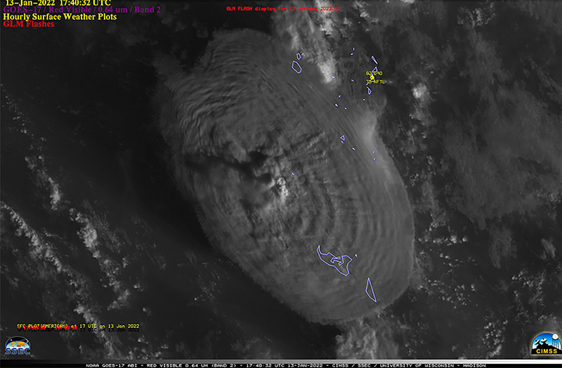
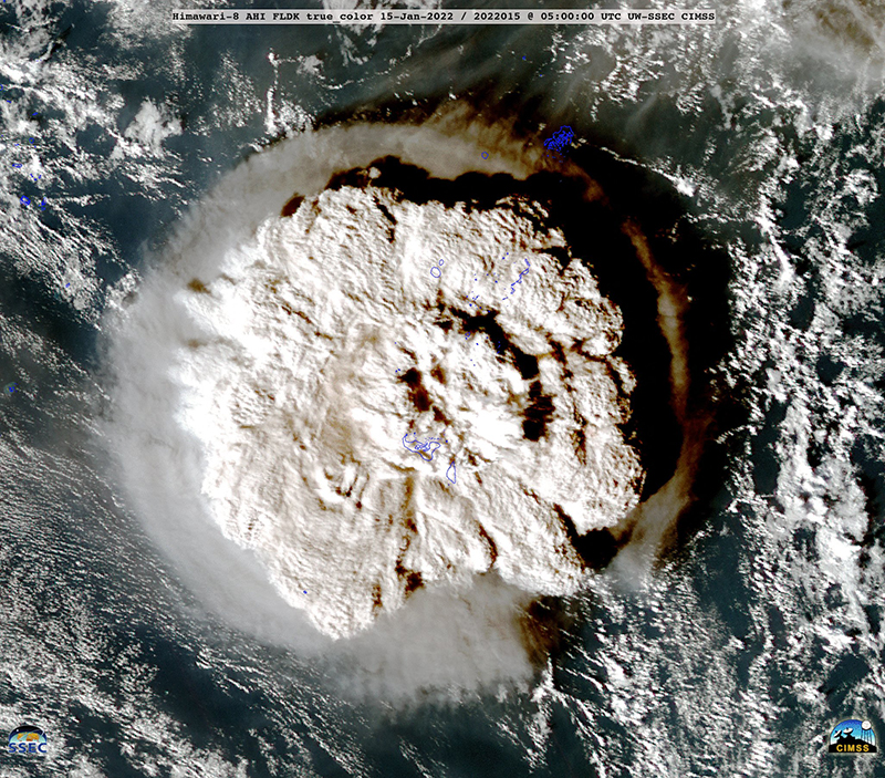
A larger submarine eruption began at 1700 on 15 January from vents just below the surface of the ocean, generating an eruption plume of gas, steam, and some ash. A report from the Wellington VAAC stated that the plume had risen to 15.2 km altitude by 1918; the top of the plume was at least 600 km in diameter by 1903 as seen in satellite images (figure 49). According to news reports and social media posts, residents in Nuku’alofa heard multiple loud booms and saw a large expanding eruption plume that eventually covered all the Tongan islands. The eruptive activity lasted eight minutes.
Ashfall eventually measuring several centimeters thick started around 1800 on 15 January and lasted about 10 hours (figure 50), which also affected water tanks and some residents reported having difficulty from breathing the ash in the air. The eruption caused a communications black out across the country, which included damaging the underwater fiber-optic cable providing access to the internet and damage to satellite terminals due to being covered in ash.
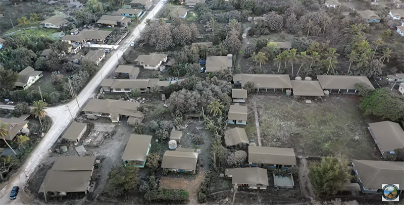 |
Figure 50. Drone image of the tsunami aftermath from the Hunga Tonga-Hunga Ha’apai eruption taken on 16 January 2022. Image shows ashfall in Nuku’alofa. Courtesy of Tonga Geological Services. |
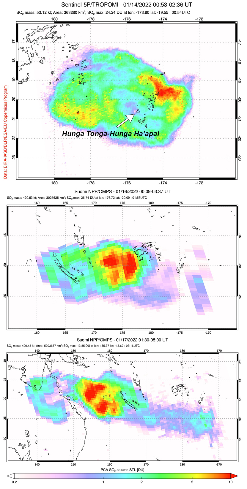
During 1719-2300 on 15 January there were almost 400,000 lightning events recorded in the plume by the GLD360 network, with 200,000 of those occurring during 1800-1900. The plume continued to rise to at least 20 km altitude, though other satellite datasets suggested that some of it may have risen as high as 30 km. At 0343 on 16 January the plume was at 19.2 km altitude. Based on volcanic ash advisories issued by the Wellington VAAC and then by the Darwin VAAC, the horizontal extent of the plume grew from 18,000 km2 at 1739 on the 15th to 12 million km2 by 1300 on 19 January. The plume narrowed and lengthened along an E-W axis, moving W over Australia. According to data from the TROPOMI instrument on the Sentinel-5P satellite, a sulfur dioxide plume was detected with a mass of roughly 50 kilotons on 14 January, 420 kilotons that drifted W on 16 January, and 400 kilotons that continued to drift W on 17 January (figure 51).
The explosions produced multiple pressure (shock) waves that rippled through surrounding weather clouds at a rate of 300 m/s, though the pressure wave from the largest explosion propagated across the planet. The sonic boom from this wave was heard at great distances, including within about two hours in New Zealand (2,300 km SW), Samoa, Fiji (500 km NW), Vanuatu, Cook Islands, and Alaska (9,370 km NE km). The pressure wave was also recorded by infrasound and weather instruments worldwide as it circled the Earth, with instruments detecting it again when it arrived from the opposite direction.
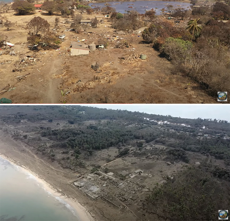
Warnings were issued for the N and E coasts of New Zealand’s North Island and the Chatham Islands; multiple boats were destroyed overnight in Tutukaka Marina in Far North (figure 52). According to an RNZ article, more than 120 people had been evacuated from the Far North between 2300 and 0000. Tsunami waves reaching 1.2 m high hit Nuku’alofa during the evening, breaching the shoreline and flooding coastal roads and properties. At Mango Island (75 km ENE), the tsunami waves reached 500 m inland and rose as high as 12 m high, destroying buildings and trees (figure 53). According to the Tongan Navy, tsunami waves that hit Mango Island reached 5-10 m high. According to an official update from the Tongan government on 20 January, tsunami waves reached up to 15 m high, which affected the W coasts of Tongatapu, 'Eua, and Ha'apai Islands and the water depth in the village of Kanokupolu was 1.5 m.
In Japan, around 230,000 people were advised to evacuate across eight prefectures due to the tsunami risk. The resulting waves were recorded in the Kominato district of Amami-Oshima Island in Kagoshima Prefecture at 2355. The waves reached 80 cm in Japan, disrupting train services, flights, and damaging harbors and boats. In Anchorage, Alaska, the US National Weather Service reported maximum waves heights of 20-100 cm on Alaskan coastlines and along the British Columbia coast, waves were 16-29 cm. By the morning of 16 January, the tsunami warning had been extended to the W coast of South Island. Reports indicated that the villages of Sopu, Kolomotua, Kolofo'ou, Ma'ufanga, Patangata were also affected by the tsunami, especially areas near Vuna Road.
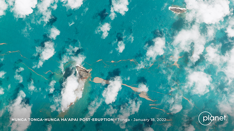
Activity during 16-31 January 2022. No new eruptive events were detected after the large explosive eruption on 15 January. A satellite image taken on 18 January showed that most of the previously combined island had been destroyed, leaving only a small part of the NE island of Hunga Tonga (200 m long) and the SW island of Hunga Ha’apai (700 m long) visible above the ocean surface (figure 54). Pumice rafts were visible to the SE of Hunga Ha’apai. The Aviation Color Code was lowered to Green on 19 January. According to the Darwin VAAC, the plume continued to drift W at altitudes between 12.8 and 19.2 km during 19-22 January; the ash was diffuse and difficult to distinguish from meteorological clouds, though the sulfur dioxide signal was stronger. The leading edge of the plume reached the E coast of Africa on 22 January, but by 2150 (local time) the Darwin VAAC noted that ash was no longer detectable.
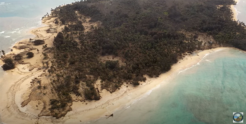
The Tongan Ministry of Foreign Affairs and Trade confirmed three deaths and multiple people injured following the explosion and tsunami on 15 January. Aerial surveillance images showed that buildings and villages had washed away or been badly damaged, roofs were covered with ash, trees were uprooted, vegetation was brown and damaged, and modified coastlines contained sediment-laden waters. All the houses on Mango Island were destroyed due to the tsunami waves; a few temporary tarpaulin shelters were still visible. Only two houses remained on Fonoifua, and extensive damage was also reported on Nomuka Island (figure 55). Evacuations began on 19 January, which included people on the islands of Mango, Atata, and Fonoifua; about 150 people were evacuated to other islands. About 89 people remained in evacuation shelters on the island of ‘Eua. According to the Tongan government, parts of the W side of Tongatapu, including Kanokupolu, were evacuated after dozens of houses were damaged (figure 55), and in the central district many houses were damaged in Kolomotu'a and on the island of 'Eua. Numerous buildings were reported gone on Atata Island. Roughly 62 survivors were evacuated from Mango Island to Tongatapu on 22 January via a Navy patrol boat. According to a news article from Radio New Zealand, two deaths were reported from a beach in Peru (over 10,000 km) due to high tsunami waves.
According to a media release from the Government of Tonga on 21 January, all the islands were affected by ashfall and tsunami waves. A relief flight from New Zealand brought telecommunication equipment and a repair vessel was sent to repair the damaged seafloor fiber-optic cable; domestic flights remained suspended. Dozens of Mw 4.5-5 earthquakes were detected in the vicinity of the volcano after the eruption, at least through 24 January, though the type of earthquake signal was unknown.
Geological Summary. The small andesitic islands of Hunga Tonga and Hunga Ha'apai are part of the western and northern remnants of the rim (~6 km diameter) of a largely submarine caldera located about 30 km SSE of Falcon Island. The topmost sequence of welded and unwelded ignimbrite units from a caldera-forming eruption was 14C dated to 1040-1180 CE (Cronin et al., 2017; Brenna et al. 2022). At least two additional welded pumice-rich ignimbrite units and nonwelded pyroclastic flow deposits, below paleosols and other volcaniclastic deposits, indicated more very large previous eruptions (Cronin et al., 2017; Brenna et al. 2022). Several submarine eruptions have occurred at this caldera system since the first recorded eruption in 1912, including 1937 and S of the islands in 1988. A short eruption in 2009 added land to to Hunga Ha'apai. At that time the two islands were each about 2 km long, displaying inward-facing sea cliffs with lava and tephra layers dipping gently away from the caldera. An eruption during December 2014-January 2015 was centered between the islands, and combined them into one larger structure. Major explosive eruptions in late 2021 initially reshaped the central part of the combined island before stronger activity in mid-January 2022 removed most of the 2014-15 material; an even larger eruption the next day sent an eruption plume high into the stratosphere, triggered shock waves through the atmosphere and tsunami across the Pacific Ocean, and left only small remnants of the islands above the ocean surface.
Information Contacts: Tonga Geological Services, 51 Vaha'akolo Road, Nuku’alofa, Tonga (URL: https://www.facebook.com/tongageologicalservice); Matangi Tonga Online, PO Box 958, Nuku‘alofa, Tonga (URL: https://matangitonga.to/); RNZ (Radio New Zealand) Pacific, PO Box 123, Wellington 6140, New Zealand (URL: https://www.rnz.co.nz); Darwin Volcanic Ash Advisory Centre (VAAC), Bureau of Meteorology, Northern Territory Regional Office, PO Box 40050, Casuarina, NT 0811, Australia (URL: http://www.bom.gov.au/info/vaac/); Wellington Volcanic Ash Advisory Centre (VAAC), Meteorological Service of New Zealand Ltd (MetService), PO Box 722, Wellington, New Zealand (URL: http://www.metservice.com/vaac/, http://www.ssd.noaa.gov/VAAC/OTH/NZ/messages.html); Planet Labs, Inc. (URL: https://www.planet.com/); NASA Global Sulfur Dioxide Monitoring Page, Atmospheric Chemistry and Dynamics Laboratory, NASA Goddard Space Flight Center (NASA/GSFC), 8800 Greenbelt Road, Goddard, MD 20771, USA (URL: https://so2.gsfc.nasa.gov/); Cooperative Institute for Meteorological Satellite Studies, University of Wisconsin-Madison, Space Science and Engineering Center, 1225 West Dayton Street, Madison, WI 53706, USA (URL: http://tropic.ssec.wisc.edu/); Sentinel Hub Playground (URL: https://www.sentinel-hub.com/explore/sentinel-playground); 1 News, New Zealand (URL: https://www.1news.co.nz/); Tanya Harrison, Planet Labs, Inc. (URL: https://twitter.com/tanyaofmars); Chris Vagasky, National Lightning Safety Council (URL: https://twitter.com/COweatherman); Simon Carn, Geological and Mining Engineering and Sciences, Michigan Technological University, 1400 Townsend Drive, Houghton, MI 49931, USA (URL: http://www.volcarno.com/, Twitter: @simoncarn).

