Report on Telica (Nicaragua) — April 2022
Bulletin of the Global Volcanism Network, vol. 47, no. 4 (April 2022)
Managing Editor: Edward Venzke.
Edited by Kadie L. Bennis. Research and preparation by Paul Berger.
Telica (Nicaragua) Weak explosions and minor ash plumes continue into late March 2022
Please cite this report as:
Global Volcanism Program, 2022. Report on Telica (Nicaragua) (Bennis, K.L., and Venzke, E., eds.). Bulletin of the Global Volcanism Network, 47:4. Smithsonian Institution. https://doi.org/10.5479/si.GVP.BGVN202204-344040
Telica
Nicaragua
12.606°N, 86.84°W; summit elev. 1036 m
All times are local (unless otherwise noted)
Weak gas-and-ash explosions have been recorded from the summit crater complex of steep-sided Telica, in NW Nicaragua, since the early 20th century (BGVN 42:01). Its current eruption began in April 2021 and has recently consisted of weak ash explosions and ash plumes, activity which continued from August 2021 into late March 2022. Information primarily comes from monthly and special bulletins posted by the Instituto Nicaragüense de Estudios Territoriales (INETER), Washington Volcanic Ash Advisory Center (VAAC), and satellite images.
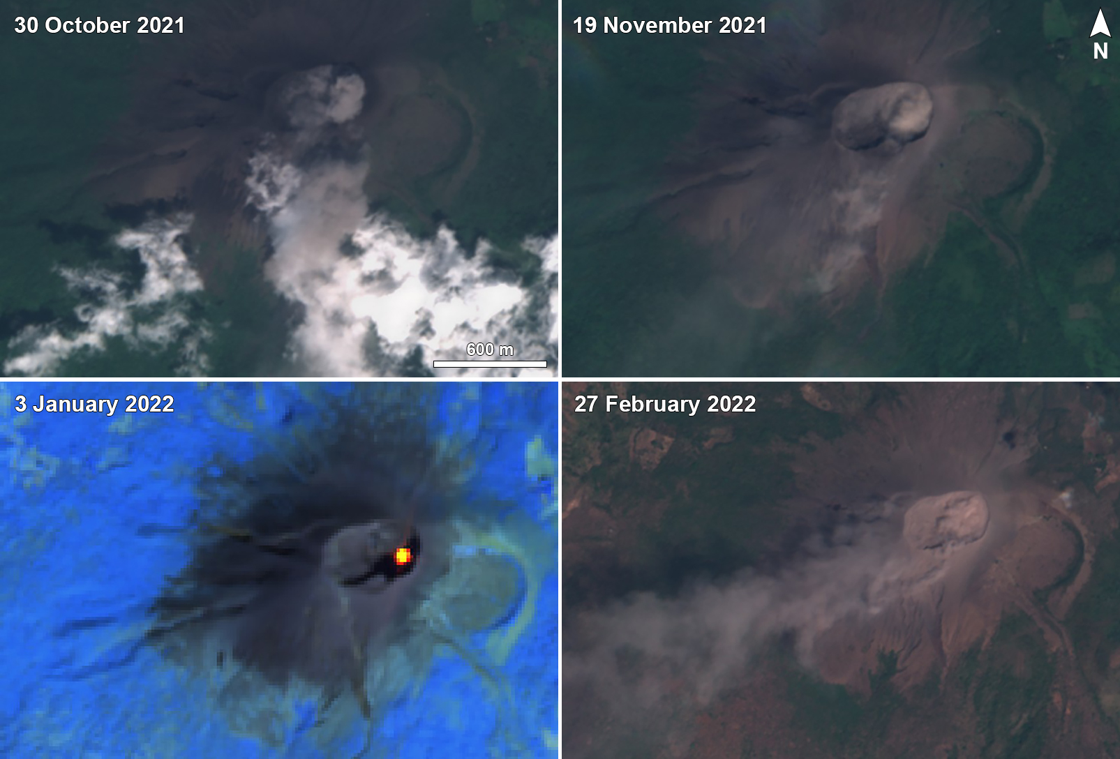
Sentinel-2 satellite images during this period showed frequent gas-and-ash emissions from the active eastern crater, intermittent ash plumes, and occasional thermal signals (figure 60). Ash plumes were last seen on satellite images on 27 March, and last reported by INETER on 29 March 2022.
INETER did not report any explosive activity during August 2021. According to INETER, at 0525 on 1 September an explosion generated an ash plume that rose 250 m above the crater rim and drifted N and NW. Emissions periodically continued later that day, without explosions, and caused minor ashfall in areas to the NW, W, and SW, including in the communities of Aguas Frías, San Pedro Nuevo, and Las Marías (7 km NNW). On 4 September, a diffuse ash plume rose to an altitude of 1.2 km (~160 m above the crater rim) and drifted less than 10 km WSW, based on satellite images and model data.
An ash plume was reported by the Washington VAAC on 4 October to 1.2 km altitude that drifted W and SW. During a field excursion on 12 October, several ejected bombs were observed in the crater ranging in diameter from 0.5-30 cm, accompanied by dark gray ash deposits. In the W part of the crater, a particularly large bomb that measured 1.5 x 0.5 m was ejected 65 m from the crater rim. According to INETER, at 1650 on 28 October a minor explosion generated an ash plume that rose 150 m above the crater rim and deposited ash on the NW flank. The event was followed by a short series of weak, low-energy explosions that generated ash plumes that rose 300 m high and drifted N and NE. Minor ashfall was reported in Aguas Frías.
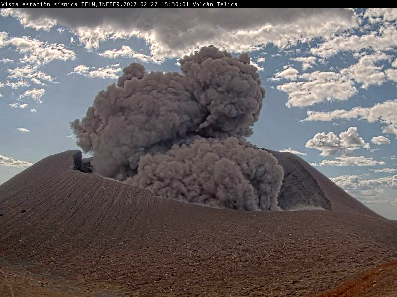
Based on satellite and webcam images, the Washington VAAC reported that during 21-24 and 27-28 February, multiple brown ash emissions rose to an altitude of 1.5 km (~460 m above the crater rim) and drifted as far as 55 km W, WSW, and SW (figure 61). Intermittent ash plumes were also reported on 1, 24, and 29 March that rose to 1.2, 1.5, and 1.5 km altitude, respectively, and drifted SW and W.
 |
Figure 61. Webcam image (color corrected) of an ash explosion at Telica on 22 February 2022 at 1530, taken from seismic station TELN on the E flank. Courtesy of INETER. |
Sulfur dioxide measurements. Sulfur dioxide measurements using the mobile-DOAS technique at Los Mendoza, a fixed station about 7 km W of the volcano, found higher concentrations during July 2021 of 30 tons/day (t/d), an increase from April-June (13-18 t/d). Emissions increased further in August (36 t/d), November (41 t/d), and December (43 t/d), which INETER correlated with greater intermittent eruptive activity.
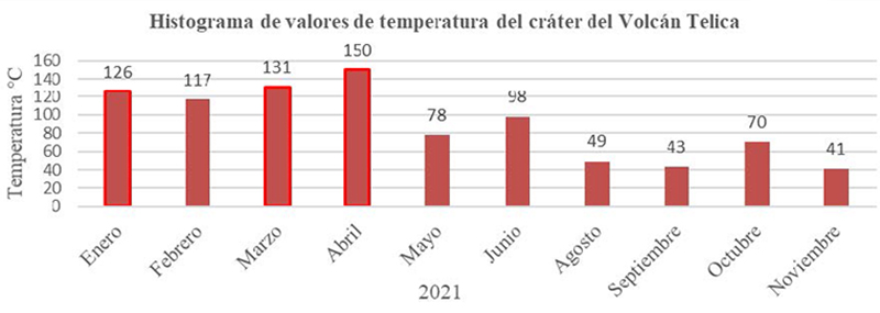
Other sulfur dioxide measurements using the mobile-DOAS technique and up to 19 transepts around the volcano found much greater average concentrations than the Los Mendoza site. The average concentration in November 2021 (544 t/d) was much greater than previous months: 286 t/d in August, 163 t/d in September, 161 t/d in October. Values dropped again in 2022 to 369 t/d in February and 118 t/d in March. In contrast, the temperatures at the crater decreased August-November, compared to January-April 2021 (figure 62).
 |
Figure 62. Histogram of temperatures taken in the crater of Telica during January-November 2021. Courtesy of INETER (Boletín mensual Sismos y Volcanes de Nicaragua, Noviembre, 2021). |
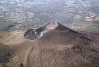
Geological Summary. Telica, one of Nicaragua's most active volcanoes, has erupted frequently since the beginning of the Spanish era. This volcano group consists of several interlocking cones and vents with a general NW alignment. Sixteenth-century eruptions were reported at symmetrical Santa Clara volcano at the SW end of the group. However, its eroded and breached crater has been covered by forests throughout historical time, and these eruptions may have originated from Telica, whose upper slopes in contrast are unvegetated. The steep-sided cone of Telica is truncated by a 700-m-wide double crater; the southern crater, the source of recent eruptions, is 120 m deep. El Liston, immediately E, has several nested craters. The fumaroles and boiling mudpots of Hervideros de San Jacinto, SE of Telica, form a prominent geothermal area frequented by tourists, and geothermal exploration has occurred nearby.
Information Contacts: Instituto Nicaragüense de Estudios Territoriales (INETER), Apartado Postal 2110, Managua, Nicaragua (URL: http://www.ineter.gob.ni/); Washington Volcanic Ash Advisory Center (VAAC), Satellite Analysis Branch (SAB), NOAA/NESDIS OSPO, NOAA Science Center Room 401, 5200 Auth Rd, Camp Springs, MD 20746, USA (URL: www.ospo.noaa.gov/Products/atmosphere/vaac); Sentinel Hub Playground (URL: https://www.sentinel-hub.com/explore/sentinel-playground).


