Report on Nevado del Ruiz (Colombia) — August 2023
Bulletin of the Global Volcanism Network, vol. 48, no. 8 (August 2023)
Managing Editor: Benjamin Andrews.
Edited by Kadie L. Bennis.
Nevado del Ruiz (Colombia) Intermittent gas-and-ash plumes, ashfall events, and seismicity during February-July 2023
Please cite this report as:
Global Volcanism Program, 2023. Report on Nevado del Ruiz (Colombia) (Bennis, K.L., and Andrews, B., eds.). Bulletin of the Global Volcanism Network, 48:8. Smithsonian Institution.
Nevado del Ruiz
Colombia
4.892°N, 75.324°W; summit elev. 5279 m
All times are local (unless otherwise noted)
Nevado del Ruiz is located in central Colombia and covers more than 200 km2. It contains the 1-km-wide, 240-m-deep Arenas summit crater. Eruptions have been documented since 1570 CE. The current eruption period has been ongoing since November 2014 and more recently has consisted of intermittent ash emissions, lava dome growth, and thermal activity (BGVN 48:02). This report describes intermittent ash plumes, ashfall events, gas-and-steam emissions, and seismicity during February through July 2023, based on information from the Servicio Geologico Colombiano (SGC) and the Observatorio Vulcanológico y Sismológico de Manizales, the Washington Volcanic Ash Advisory Center (VAAC) notices, and various satellite data.
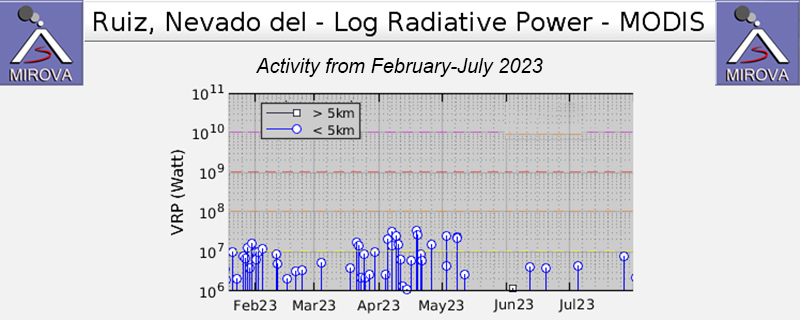
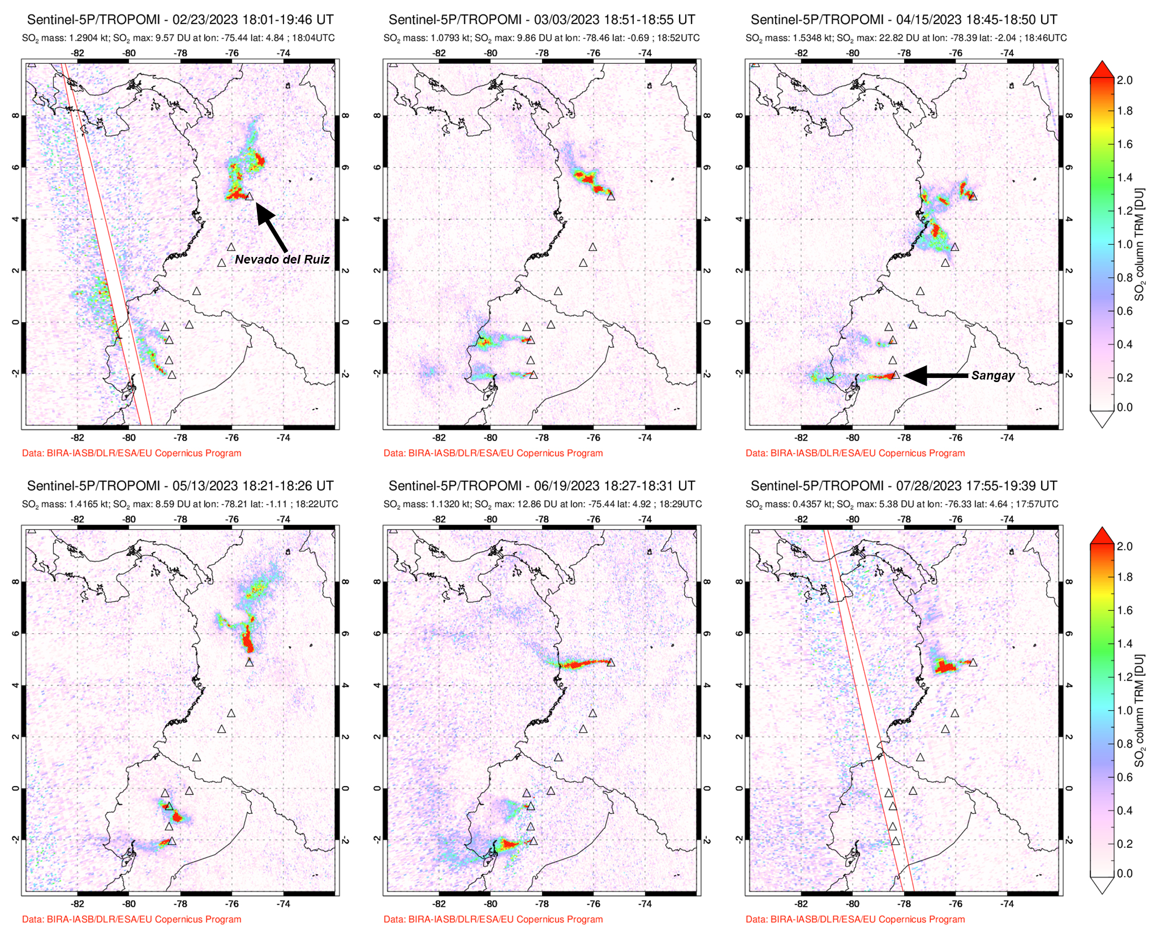
Occasional thermal anomalies were recorded during February through July 2023, with slightly stronger and more frequent anomalies occurring during mid-March through early May, according to MIROVA (Middle InfraRed Observation of Volcanic Activity) analysis of MODIS satellite data (figure 143). A total of seven thermal alerts were detected by the MODVOLC thermal alert system on 22 March, 7, 10, and 19 April, and 8 May. Some of that stronger thermal activity was captured in infrared satellite images on 7 February, 18 April, 23 April, and 8 May; weather clouds often obscured clear views of the summit (figure 144). According to data from the TROPOMI instrument on the Sentinel-5P satellite, sulfur dioxide plumes were frequently detected throughout the reporting period, many of which had maximum column densities that exceeded 2 Dobson Units (DU) and drifted in different directions (figure 145).
Activity during February and most of March was relatively low and consisted of gas-and-steam and ash emissions and low seismicity. Gas-and-steam plumes mainly composed of sulfur dioxide were reported once a week, rising 1.3-3.2 km above the summit and drifting in different directions during February, the latter of which was recorded on 8 February. During March gas-and-ash plumes rose 2-3 km above the summit and drifted NW and SW, the latter of which occurred on 11 March. On 4 March seismic signals increased in intensity and were associated with mostly continuous ash emissions with occasional pulses. Ashfall was reported in Manizales (27 km NW). Webcam images and reports from residents captured several ash emissions during 18-20 March. The emissions were associated with seismic signals indicating fluid movement in the conduit. A gas-and-ash emission rose 2.7 km above the summit and drifted SW at 0902 on 20 March and was visible from several municipalities including: Caldas, Tolima, and Risaralda. This plume was one of the tallest recorded in recent days. Two notable seismic increases were recorded on 24 and 31 March, mainly characterized by rock-fracturing earthquakes; seismicity mainly affected the SW flank. On 28 March there were 6,500 rock-fracturing events detected, the highest daily count since 2010. The number of daily events continued to increase and on 29 March the seismic network recorded 11,000 earthquakes, the highest daily count since seismic monitoring began in 1985. On 30 March, 11,600 earthquakes were detected. The Alert Level was raised to Orange, Level II (the second highest level on a four-level scale) on 30 March. In addition to the seismic swarm, seismic signals indicating fluid movement continued, some of which were associated with ash emissions. On 30 March ash emissions rose as high as 1.8 km above the summit and drifted NW and SW, and the next day, gas-and-ash emissions reached 1.3 km above the summit and drifted SW and SE. The total number of earthquakes on 31 March was 8,800.
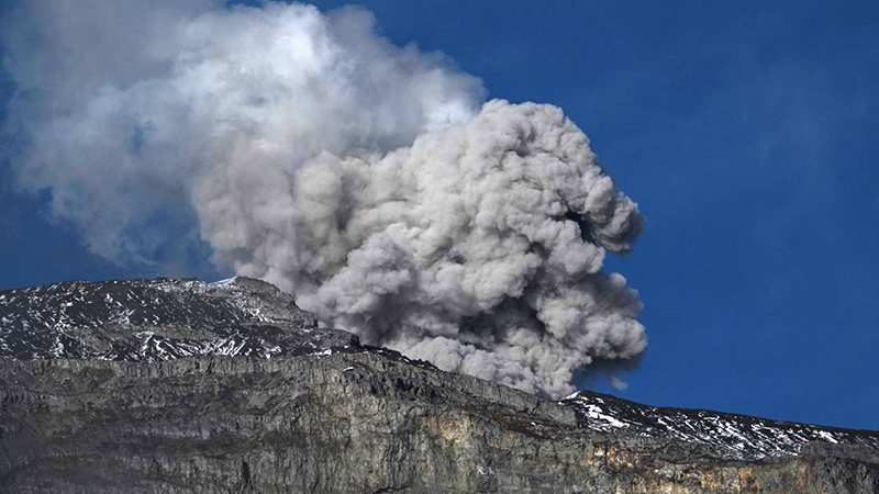
During the first half of April, seismicity showed a gradual decrease in the number of recorded events, ranging from 5,000-10,000 events during 1-5 April to 500-3,000 during 6-13 April. For the rest of the month, about 100 events occurred each day. Gas-and-ash emissions rose 1.2 km above the summit and drifted SW and NW during 1-2 April; officials from the Los Navados National Natural Park reported ashfall in Brisas and Potosí. During 3-4 April gas-and-ash plumes rose 1.1-1.5 km above the summit and drifted SW and NW. On 5 April at 0216 a strong earthquake of M 3.9 was recorded and felt by residents in Villamaría (28 km NW). SGC noted that this was the highest magnitude earthquake recorded in the SW part of the volcano since instrumental monitoring was installed in 1985. According to a news article, 87 people had self-evacuated after the government called for a voluntary evacuation of roughly 2,500 families. Continuous gas-and-ash emissions rose 1.2-1.8 km above the summit and drifted SW, SE, NE, and E during 6-10 April, based on webcam images and reports from residents in La Cabaña (Murillo, Tolima) (figure 146). Drumbeat-type seismicity associated with the growth of the lava dome located at the bottom of the Arenas crater was detected on 8, 13, 14, 17, 18, and 21 April. During 11-13 April gas-and-ash plumes rose 1.8-2.5 km above the summit and drifted N, NE, SW, and NW, and there were reports of ashfall in Villamaría (Caldas) and Filandia (Quindío). As many as 2,000 daily drumbeat-type events were also recorded on 13 April. During 0759-1113 on 14 April and from 1515 on 14 April to 0057 on 15 April seismicity intensified and corresponded to continuous ash emissions that rose as high as 1.5 km above the summit and drifted SW, as observed by residents in Murillo and Manizales. During 16-19 and 21-22 April gas-and-steam plumes possibly containing some ash rose 1.1-1.8 km above the summit and drifted in different directions; ashfall was reported in Anzoátegui, Tolima on 18 April after an ash plume was reported at 0711. Pulsating ash emissions were visible in webcam images during 23-29 April, rising 1.1-2.5 km above the summit and drifting in multiple directions. The ash emissions on 25 April were visible from Tolima, Caldas, and Risaralda. The ash emission reported at 0837 on 27 April was followed by reports of ashfall in Manizales a few hours later.
 |
Figure 146. Photo of an ash cloud from Nevado del Ruiz as seen from Murillo, Tolima, Colombia taken on 7 April 2023. Courtesy of Joaquin Sarmiento via CNN. |
According to SGC, the sulfur dioxide emission rate increased during the first week of May compared to those emitted during April. Drumbeat-type events continued to occur on 6, 16, 17, 26, 27, and 31 May. Gas-and-steam plumes rose 1.9 km and 2.7 km above the summit on 12 and 25 May, respectively, and drifted generally W. A sulfur odor was reported in several parts of Manizales on 15 May. A significant thermal anomaly was observed within the crater on 31 May. On that same day, a sulfur odor was reported in Cerro Gualí.
SGC reported that the rate of sulfur dioxide emissions had decreased in June compared to May. Several short-duration drumbeat-type events were recorded on 1, 5, and 26 June. Gas-and-steam emissions that possibly contained some ash rose 2-2.4 km above the summit and drifted NW on 4 June. As a result, minor ashfall was reported in Manizales and Villamaría. Continuous ash emissions was visible in webcam images during the afternoon of 20 June and ashfall was reported in Manizales. Ash emissions rose as high as 1.3 km above the summit on 21 June and drifted WSW; they continued to rise as high as 4 km above the summit that same day. Crater incandescence was observed, coinciding with pulsating ash emissions during 20-23 June. Gas-and-ash plumes rose 900-1,800 m above the summit during 24-27 June and drifted NW. Minor ashfall was reported in Villamaría and Manizales on 22 and 25 June, respectively. The Alert Level was lowered to Yellow, Level III (the second level on a four-level scale) on 27 June. SGC noted that monitoring data was more stable in recent weeks, thermal anomalies at the lava dome were less intense, ash emissions had decreased, and gas-and-steam emissions remained relatively stable.
Low seismicity and gas-and-ash emissions were reported during July. Drumbeat-type events were detected on 1, 3, 7, 8, 10, 12, 15, 17, 24, 26, 27, 28, and 29 July. Incandescence was observed on 4 July, accompanied by an ash emission at 2048 that rose 2km above the summit and drifted NW and SW. Occasional gas-and-steam plumes mainly consisting of sulfur dioxide rose 1.2-1.8 km above the summit and drifted NW and WSW. During 24-25 July a gas-and-ash plume rose 1.8 km above the summit and drifted NW and WNW, causing light ashfall in Manizales. On 27 July at 0617 a gas-and-ash plume rose 2.3-3.5 km above the summit and drifted NW and WNW; light ashfall was reported in Manizales on several occasions.
Geological Summary. Nevado del Ruiz is a broad, glacier-covered volcano in central Colombia that covers more than 200 km2. Three major edifices, composed of andesitic and dacitic lavas and andesitic pyroclastics, have been constructed since the beginning of the Pleistocene. The modern cone consists of a broad cluster of lava domes built within the caldera of an older edifice. The 1-km-wide, 240-m-deep Arenas crater occupies the summit. The prominent La Olleta pyroclastic cone located on the SW flank may also have been active in historical time. Steep headwalls of massive landslides cut the flanks. Melting of its summit icecap during historical eruptions, which date back to the 16th century, has resulted in devastating lahars, including one in 1985 that was South America's deadliest eruption.
Information Contacts: Servicio Geologico Colombiano (SGC), Diagonal 53 No. 34-53 - Bogotá D.C., Colombia (URL: https://www.sgc.gov.co/volcanes); MIROVA (Middle InfraRed Observation of Volcanic Activity), a collaborative project between the Universities of Turin and Florence (Italy) supported by the Centre for Volcanic Risk of the Italian Civil Protection Department (URL: http://www.mirovaweb.it/); Hawai'i Institute of Geophysics and Planetology (HIGP) - MODVOLC Thermal Alerts System, School of Ocean and Earth Science and Technology (SOEST), Univ. of Hawai'i, 2525 Correa Road, Honolulu, HI 96822, USA (URL: http://modis.higp.hawaii.edu/); NASA Global Sulfur Dioxide Monitoring Page, Atmospheric Chemistry and Dynamics Laboratory, NASA Goddard Space Flight Center (NASA/GSFC), 8800 Greenbelt Road, Goddard MD 20771, USA (URL: https://so2.gsfc.nasa.gov/); Copernicus Data Space Ecosystem, European Space Agency (URL: https://dataspace.copernicus.eu/browser/); CNN, One CNN Center, 12th Floor, North Tower, Atlanta, GA 30303, USA, “A deadly volcano could erupt ‘within days or weeks’ in Colombia. But only a small fraction of locals have evacuated”(URL: https://edition.cnn.com/2023/04/15/americas/nevado-del-ruiz-colombia-volcano-intl-latam/index.html).


