Report on Santa Maria (Guatemala) — September 2023
Bulletin of the Global Volcanism Network, vol. 48, no. 9 (September 2023)
Managing Editor: Benjamin Andrews.
Edited by Kadie L. Bennis.
Santa Maria (Guatemala) Frequent explosions, lava flows, ash plumes, and pyroclastic flows during April-July 2023
Please cite this report as:
Global Volcanism Program, 2023. Report on Santa Maria (Guatemala) (Bennis, K.L., and Andrews, B., eds.). Bulletin of the Global Volcanism Network, 48:9. Smithsonian Institution.
Santa Maria
Guatemala
14.757°N, 91.552°W; summit elev. 3745 m
All times are local (unless otherwise noted)
The Santiaguito lava-dome complex of Guatemala's Santa María volcano has been actively erupting since 1922. The lava dome-complex lies within a large crater on the SW flank of Santa Maria formed during the 1902 eruption. Ash explosions, pyroclastic flows, and lava flows have emerged from Caliente, the youngest of the four vents in the complex, for more than 40 years. A lava dome that appeared within the summit crater of Caliente in October 2016 has continued to grow, producing frequent block avalanches down the flanks. Recent activity has included active lava flows, explosions, ash plumes, and ashfall (BGVN 48:04). This report covers activity during April through July 2023, based on information from Guatemala's INSIVUMEH (Instituto Nacional de Sismologia, Vulcanologia, Meterologia e Hidrologia) and satellite data.
Activity during April consisted of daily gas-and-steam emissions, nighttime crater incandescence, weak-to-moderate explosions that produced gas-and-ash emissions, and incandescent avalanches of material that descended the W, S, SE, SW, E, WSW, and N flanks of the Caliente dome. Gas-and-ash emissions rose 500-3,500 m above the crater and drifted W, SW, S, and E. An active lava flow continued mainly in the Zanjón Seco (SW) and San Isidro (W), accompanied by block collapses that raised ash clouds to several hundred meters high. By 4 April it was 4.3 km long on the SW flank of Caliente and continued to generate weak-to-moderate avalanches at the front and margins of the flows; pyroclastic flows also accompanied this activity during 3-4, 7-8, 11-12, 15-16, and 23-24 April. During 9-10 April an ash plume rose 700 m above the crater and drifted 8 km SW. During 15-16 April ashfall was reported in San Marcos Palajunoj (8 km SW), Las Marías (10 km S), Belén (10 km S), and Calaguache (9 km S). During 18-19 April ashfall was recorded in Finca El Faro (7 km S). On 28 April a lahar descended the Cabello de Angel River, a tributary of the Nimá I and Samalá rivers on the E flank and was registered by the nearby seismic stations. On 30 April at 0920 a moderate explosion generated a pyroclastic flow that traveled 5 km SW and produced an ash plume that rose 100 m along the flow. Seismic data confirmed that the event lasted 40 minutes.
Daily gas-and-steam emissions, explosions, and nighttime crater incandescence continued during May. Gas-and-steam emissions rose 200-800 m above the crater and drifted S, SW, W, and SE. Ash plumes rose 500-3,500 m above the crater and drifted SW, SE, S, and W. Block-and-ash avalanches continued around the crater, on the S, SE, SW, W, E, and N flanks, and at the middle and front of the W lava flow. The lava flow remained active on the SW, W, and WSW flanks, generating avalanches along its path. It was 4.3 km in length and accompanied by occasional pyroclastic flows, such as during 5-6, 25-26, and 29-30 May. During 5-6, 9-10, 13-14, 21-22, 25-26, and 29-30 May about 40 explosions were recorded each day, which generated ash plumes that rose 1-3.5 km above the crater and drifted SW, S, SW, and SE. Ashfall was reported in San Marcos Palajunoj and Loma Linda (7 km W) during 5-6 May and in Finca El Faro, Finca El Patrocinio, and Las Marías during 9-10 May. During 26-27 and 30-31 May ashfall was reported in El Faro, La Florida (6 km S), and Patzulin (SW flank).
During June, daily gas-and-steam emissions, explosions, and nighttime crater incandescence persisted. Gas-and-steam emissions rose 200-3,000 m above the crater and drifted SE, W, S, and SW. Avalanches of material were recorded on all flanks of the volcano, as well as from the lava flow; short pyroclastic flows were reported during 2-3, 6-7, 10-11, 18-19, 22-23, 26-27, and 28-29 June affecting the San Isidro drainage. Gas-and-ash plumes rose 500-1,000 m above the crater and drifted W and SW. The active lava flow continued on the WSW, SW, W, and SE flanks. During 2-3, 6-7, 10-11, 18-19, 26-27, and 28-29 June there were an average of 40 explosions each day that produced ash plumes 3.5 km above the crater and drifted S, SE, W, SW, and NW. During 4-5 June ashfall was observed in El Faro, La Florida, and Patzulin. During 8-9 June ashfall was reported in San José and La Quina. During 23-26 June dome incandescence reflected on the eruption plumes was visible up to 500 m above the crater. On 23 June a lahar descended the Río Cabello de Ángel on the E flank. The lahar carried fine volcanic material, volcanic blocks up to 1 m in diameter, and tree trunks and branches.
Similar activity continued with explosions, crater incandescence, and an active lava flow during July. Gas-and-steam emissions rose 300-1,000 m above the crater and drifted W, SW, and NW. Gas-and-ash plumes rose 500-1,000 m above the crater and drifted W, SW, and NW. The continuously active lava flow on the WSW, SW, W, and S flanks caused frequent avalanches of material down the W, SW, S, E, N, and SE flanks, occasionally generating pyroclastic flows in the San Isidro drainage.
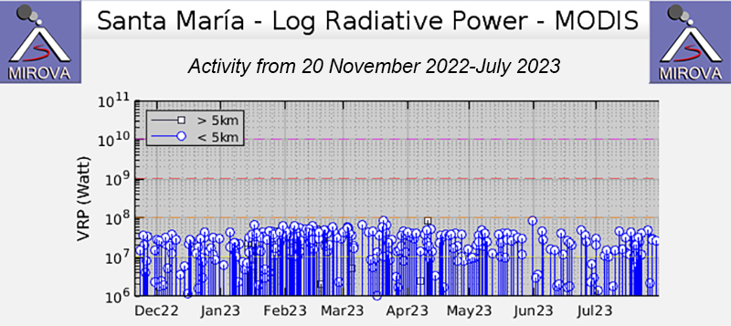
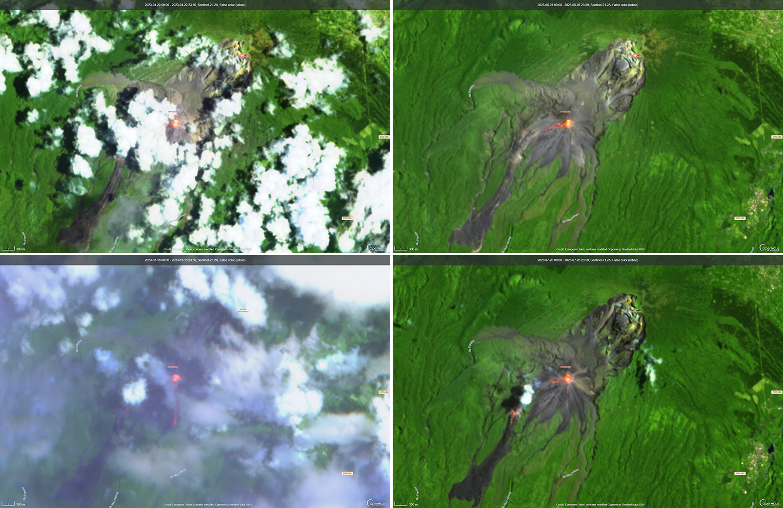
The MIROVA (Middle InfraRed Observation of Volcanic Activity) graph showed frequent moderate-power thermal anomalies during the reporting period (figure 138). A total of 49 MODVOLC thermal alerts were issued on 1, 2, 3, 5, 9, 12, 16, 17, 18, 21, 22, 25, and 27 April, 5, 7, 9, 12, 19, 21, and 24 May, 9, 18, and 24 June, and 15, 21, 22, and 26 July. Incandescent avalanches of material and active lava flows were occasionally visible over the Caliente dome and on the S and W flanks in infrared satellite imagery (figure 139).
Geological Summary. Symmetrical, forest-covered Santa María volcano is part of a chain of large stratovolcanoes that rise above the Pacific coastal plain of Guatemala. The sharp-topped, conical profile is cut on the SW flank by a 1.5-km-wide crater. The oval-shaped crater extends from just below the summit to the lower flank, and was formed during a catastrophic eruption in 1902. The renowned Plinian eruption of 1902 that devastated much of SW Guatemala followed a long repose period after construction of the large basaltic-andesite stratovolcano. The massive dacitic Santiaguito lava-dome complex has been growing at the base of the 1902 crater since 1922. Compound dome growth at Santiaguito has occurred episodically from four vents, with activity progressing E towards the most recent, Caliente. Dome growth has been accompanied by almost continuous minor explosions, with periodic lava extrusion, larger explosions, pyroclastic flows, and lahars.
Information Contacts: Instituto Nacional de Sismologia, Vulcanologia, Meteorologia e Hydrologia (INSIVUMEH), Unit of Volcanology, Geologic Department of Investigation and Services, 7a Av. 14-57, Zona 13, Guatemala City, Guatemala (URL: http://www.insivumeh.gob.gt/); MIROVA (Middle InfraRed Observation of Volcanic Activity), a collaborative project between the Universities of Turin and Florence (Italy) supported by the Centre for Volcanic Risk of the Italian Civil Protection Department (URL: http://www.mirovaweb.it/); Hawai'i Institute of Geophysics and Planetology (HIGP) - MODVOLC Thermal Alerts System, School of Ocean and Earth Science and Technology (SOEST), Univ. of Hawai'i, 2525 Correa Road, Honolulu, HI 96822, USA (URL: http://modis.higp.hawaii.edu/); Copernicus Browser, Copernicus Data Space Ecosystem, European Space Agency (URL: https://dataspace.copernicus.eu/browser/).


