Report on Fuego (Guatemala) — September 2023
Bulletin of the Global Volcanism Network, vol. 48, no. 9 (September 2023)
Managing Editor: Benjamin Andrews.
Edited by Kadie L. Bennis.
Fuego (Guatemala) Daily explosions, ash plumes, ashfall, and pyroclastic flows during April-July 2023
Please cite this report as:
Global Volcanism Program, 2023. Report on Fuego (Guatemala) (Bennis, K.L., and Andrews, B., eds.). Bulletin of the Global Volcanism Network, 48:9. Smithsonian Institution.
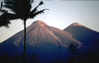
Fuego
Guatemala
14.473°N, 90.88°W; summit elev. 3763 m
All times are local (unless otherwise noted)
Fuego is one of three large stratovolcanoes overlooking the city of Antigua, Guatemala. It has been erupting since January 2002, with recorded eruptions dating back to 1531 CE. Activity has consisted of ashfall, pyroclastic flows, lava flows, and lahars. Frequent explosions with ash emissions, block avalanches, and lava flows have persisted since 2018. Recently, activity has been characterized by daily explosions, gas-and-ash plumes, avalanches of material, and ashfall (BGVN 48:04). This report describes similar activity during April through July 2023, using information from the Instituto Nacional de Sismologia, Vulcanología, Meteorología e Hidrologia (INSIVUMEH) daily reports and various satellite data.
Daily explosions reported from April through July 2023 generated ash plumes to 6 km altitude that generally drifted as far as 30 km in multiple directions. The explosions also caused rumbling sounds of varying intensities, with shock waves that vibrated the roofs and windows of homes near the volcano. Incandescent pulses of material rose as high as 350 m above the crater, accompanied by block avalanches that descended several drainages in different directions. Light ashfall was also frequently reported in nearby communities (table 28). MIROVA (Middle InfraRed Observation of Volcanic Activity) analysis of MODIS satellite data showed moderate-power thermal anomalies during April through mid-May and a high frequency (figure 170). By mid-May, there was a notable decline in both power and frequency; only five anomalies were recorded during early-to-mid-June and 14 during July. A total of 33 MODVOLC thermal alerts were issued: 19 during April, 10 during May, one during June, and three during July. Some of these stronger thermal hotspots were also visible in infrared satellite imagery at the summit crater on clear weather days, which also showed occasional incandescent block avalanches descending the NW, SW, and W flanks, accompanied by ash plumes that drifted generally W (figure 171).
Table 28. Activity at Fuego during April through July 2023 included multiple explosions every hour. Ash emissions rose as high as 6 km altitude and drifted in multiple directions as far as 30 km, causing ashfall in many communities around the volcano. Data from daily INSIVUMEH reports.
| Month | Explosions per hour | Maximum ash plume altitude | Ash plume distance (km) and direction | Drainages affected by block avalanches | Communities reporting ashfall |
| Apr 2023 | 4-14 | 5.5 km | W, SW, S, SE, and E, 10-65 km | Seca, Taniluyá, Ceniza, Las Lajas, Trinidad, El Jute, Honda, and Santa Teresa | Sangre de Cristo, San Pedro Yepocapa, Quisaché, Ojo de Agua, El Porvenir, Panimaché I and Panimaché II, Morelia, Santa Sofía, La Rochela, Finca Palo Verde, Yucales, Finca La Asunción, Aldeas, San Andrés, Las Palmas, Sinquinala, El Rodeo, Alotenango, El Zapote, Ceilán, Trinidad, and San Andrés Osuna |
| May 2023 | 1-10 | 6 km | S, SW, W, NW, N, E, and SE, 4-200 km | Ceniza, Santa Teresa, Las Lajas, and Taniluyá | Panimaché I and II, Morelia, Finca La Asunción, La Rochela, Ceilán, El Porvenir, Finca Palo Verde, Sangre de Cristo, Yepocapa, Santa Sofía, Los Yucales, Santa Lucía Cotzumalguapa, Siquinalá, San Andrés Osuna, and El Zapote |
| Jun 2023 | 1-6 | 4.8 km | S, SE, W, NW, SW, and WSW, 10-30 km | Ceniza, Santa Teresa, Taniluyá, Trinidad, Las Lajas, Honda, Seca, and El Jute | La Rochela, San Andrés Osuna, El Zapote, Panimaché I and II, Morelia, Finca La Asunción, Santa Sofía, Ceilán, El Porvenir, Yepocapa, Palo Verde, Sangre de Cristo, La Soledad, Acatenango, and Yucales |
| Jul 2023 | 1-15 | 4.8 km | W, SW, and NW, 10-30 km | Ceniza, Santa Teresa, Seca, Trinidad, El Jute, Las Lajas, Honda, and Taniluyá | Panimaché I and II, Morelia, Santa Sofía, El Porvenir, Yucales, Sangre de Cristo, San Pedro Yepocapa, El Porvenir, Finca la Asunción, Palo Verde, and Acatenango |
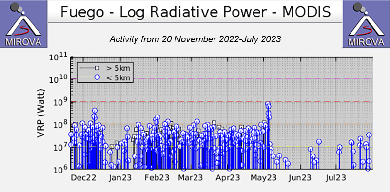 |
Figure 170. Moderate-power and frequent thermal activity was detected at Fuego during April through mid-May 2023, based on this MIROVA graph (Log Radiative Power). There was a notable decline in both strength and frequency in mid-May. Only five anomalies were recorded during early-to-mid June, and 14 during July. Courtesy of MIROVA. |
 |
Figure 171. Infrared (bands B12, B11, B4) satellite images showing a persistent thermal anomaly at the summit crater of Fuego on 14 April 2023 (top left), 19 May 2023 (top right), 18 June 2023 (bottom left), and 13 July 2023 (bottom right). Gray ash plumes were visible drifting SW and W on 14 April, 18 June, and 13 July. Incandescent avalanches of material affected the NW and SW flanks on 14 April and the W flank on 13 July. Courtesy of Copernicus Browser. |
Activity during April consisted of 4-14 daily explosions, which produced ash plumes that rose to 4.3-5.5 km altitude and drifted 5-30 km W, SW, S, SE, and E; during 21-22 April ash plumes that rose to 4.5-4.7 km altitude drifted as far as 65 km SW and S. Explosions were accompanied by rumbling sounds and weak-to-moderate shock waves. Light ashfall was reported in Sangre de Cristo (8 km WSW), San Pedro Yepocapa (8 km NW), Quisaché (8 km NW), Ojo de Agua (32 km NW), El Porvenir (11 km SW), Panimaché I and Panimaché II (8 km SW), Morelia (9 km SW), Santa Sofía (12 km SW), La Rochela (8 km SSW), Finca Palo Verde (10 km WSW), Yucales (12 km SW), Finca La Asunción (12 km SW), Aldeas, San Andrés (12 km SSW), Las Palmas, Sinquinalá (20 km SW), El Rodeo (10 km SSE), Alotenango (8 km ENE), El Zapote (10 km SSE), Ceilán (8 km S), Trinidad (S), and San Andrés Osuna (11 km SSW). Pulses of incandescent material were visible 100-350 m above the crater and covered the upper part of the cone; during 22-23 April material was deposited to the S and SE. Avalanches of material descended the Seca (W), Taniluyá (SW), Ceniza (SSW), Las Lajas (SE), Trinidad (S), El Jute (ESE), Honda (E), and Santa Teresa (W) drainages, sometimes extending to vegetated areas.
Daily explosions ranged between 1 and 10 per hour during May, which generated ash plumes that rose 4-5.5 km altitude and drifted 4-35 km S, SW, W, NW, N, E, and SE. Rumblings were heard with shock waves that vibrated the roofs and windows of nearby houses. Incandescent ejecta was visible 100-350 m above the crater. Weak-to-moderate avalanches of material descended the Ceniza, Santa Teresa, Las Lajas, and Taniluyá drainages, sometimes reaching vegetated areas. Light ashfall was reported in Panimaché I and II, Morelia, Finca la Asunción, La Rochela, Ceilán, El Porvenir, Finca Palo Verde, Sangre de Cristo, Yepocapa, Santa Sofía, Los Yucales (12 km SW), Santa Lucía Cotzumalguapa (22 km SW), Siquinalá, San Andrés Osuna, and El Zapote. On 2 May lahars were reported in the Las Lajas, El Jute, Ceniza, and Seca drainages, carrying tree branches and trunks and blocks measuring up to 1.5 m in diameter. The INSIVUMEH surveillance network recorded a pyroclastic flow descending the Ceniza drainage at 1618 (figure 172). On 4 May INSIVUMEH field observers reported an increase in volcanic activity starting at 0200. A lava flow formed in the Ceniza drainage, which produced constant avalanches. An ash plume rose to 6 km altitude and drifted 35-200 km W and SW, according to GOES-16 satellite images (figure 173). Pyroclastic flows were also reported moving down the Ceniza, Seca, Santa Teresa, and Las Lajas drainages traveling 5-7 km. The pyroclastic flows caused abundant ashfall in communities near these drainages, which covered vegetation, crops, roofs, patios, streets, and paths with accumulations up to 2 mm thick. On 12, 25, 28, and 30 May rain generated a lahar in the Ceniza drainage that transported tree branches and trunks, as well as blocks up to 1.5 m in diameter. On 29 May a lahar was reported in the Santa Teresa drainage.
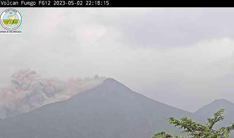 |
Figure 172. Webcam image of a pyroclastic flow descending the Ceniza drainge from Fuego on 2 May 2023. Courtesy of INSIVUMEH (BOLETÍN VULCANOLÓGICO ESPECIAL BEFGO #017-2023). |
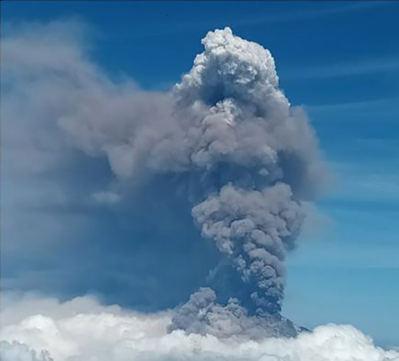 |
Figure 173. Photo of a significant, gray ash plume that rose more than 6 km altitude and drifted more than 50 km W and SW from Fuego on 4 May 2023. Photo was taken by an observer at the top of the Agua volcano. Courtesy of INSIVUMEH (BOLETÍN VULCANOLÓGICO ESPECIAL BEFGO #022-2023). |
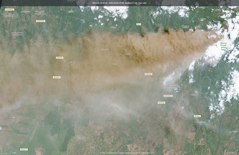 |
Figure 174. Satellite image showing a notable brown ash plume drifting several kilometers W from Fuego on 4 May 2023. Courtesy of Copernicus Browser. |
There were 1-6 daily explosions recorded during June, which produced ash plumes that rose to 4.2-4.8 km altitude and drifted 10-30 km S, SE, W, NW, SW, and WSW. During the night and early morning crater incandescence was often observed. Incandescent pulses of material rose 150-200 m above the crater. Light ashfall was reported in La Rochela, San Andrés Osuna, El Zapote, Panimaché I and II, Morelia, Finca la Asunción, Santa Sofía, Ceilán, El Porvenir, Yepocapa, Palo Verde, Sangre de Cristo, La Soledad (11 km N), Acatenango, and Yucales. Avalanches of material descended the Ceniza, Santa Teresa, Taniluyá, Trinidad, Las Lajas, Honda, Seca, and El Jute drainages. On 1, 16, 21, 29, and 30 June lahars descended the Ceniza drainage, transporting tree branches and trunks and blocks up to 3 m in diameter. On 23 June a lahar was reported in the El Jute drainage, carrying blocks up to 1 m in diameter, fine sediment, and tree trunks and branches.
During July, 1-15 daily explosions were reported, which generated ash plumes that rose to 4.2-4.8 km altitude and drifted 10-30 km W, SW, and NW. Some explosions were accompanied by avalanches of material that traveled down the Ceniza, Santa Teresa, Seca, Trinidad, El Jute, Las Lajas, Honda, and Taniluyá drainages. Ashfall was observed in Panimaché I and II, Morelia, Santa Sofía, El Porvenir, Yucales, Sangre de Cristo, San Pedro Yepocapa, El Porvenir, Finca la Asunción, Palo Verde, and Acatenango. Incandescent pulses rose 50-200 m above the crater during the second half of the month. On 1 July lahars were reported in the Ceniza, Seca, and El Mineral drainages, carrying tree branches and trunks and blocks up to 1.5 m in diameter. On 3, 8, 16, and 24 July a lahar was observed in the Las Lajas drainage. Lahars were reported in the Ceniza drainage on 7, 8, 12, 15, 16, 29, and 30 July carrying blocks up to 3 m in diameter. On 24 July a lahar occurred in the Trinidad drainage. Weak lahars were reported in the Las Lajas and El Jute drainages on 29 July. On 30 July a lahar was observed in the Santa Teresa and El Mineral drainages, carrying blocks up to 1 m in diameter.
Geological Summary. Volcán Fuego, one of Central America's most active volcanoes, is also one of three large stratovolcanoes overlooking Guatemala's former capital, Antigua. The scarp of an older edifice, Meseta, lies between Fuego and Acatenango to the north. Construction of Meseta dates back to about 230,000 years and continued until the late Pleistocene or early Holocene. Collapse of Meseta may have produced the massive Escuintla debris-avalanche deposit, which extends about 50 km onto the Pacific coastal plain. Growth of the modern Fuego volcano followed, continuing the southward migration of volcanism that began at the mostly andesitic Acatenango. Eruptions at Fuego have become more mafic with time, and most historical activity has produced basaltic rocks. Frequent vigorous historical eruptions have been recorded since the onset of the Spanish era in 1524, and have produced major ashfalls, along with occasional pyroclastic flows and lava flows.
Information Contacts: Instituto Nacional de Sismologia, Vulcanologia, Meteorologia e Hydrologia (INSIVUMEH), Unit of Volcanology, Geologic Department of Investigation and Services, 7a Av. 14-57, Zona 13, Guatemala City, Guatemala (URL: http://www.insivumeh.gob.gt/ ); MIROVA (Middle InfraRed Observation of Volcanic Activity), a collaborative project between the Universities of Turin and Florence (Italy) supported by the Centre for Volcanic Risk of the Italian Civil Protection Department (URL: http://www.mirovaweb.it/); Hawai'i Institute of Geophysics and Planetology (HIGP) - MODVOLC Thermal Alerts System, School of Ocean and Earth Science and Technology (SOEST), Univ. of Hawai'i, 2525 Correa Road, Honolulu, HI 96822, USA (URL: http://modis.higp.hawaii.edu/); Copernicus Browser, Copernicus Data Space Ecosystem, European Space Agency (URL: https://dataspace.copernicus.eu/browser/).