Report on Ioto (Japan) — January 2024
Bulletin of the Global Volcanism Network, vol. 49, no. 1 (January 2024)
Managing Editor: Kadie Bennis.
Ioto (Japan) New eruption with discolored water, ejecta, and floating pumice during October-December 2023
Please cite this report as:
Global Volcanism Program, 2024. Report on Ioto (Japan) (Bennis, K.L., ed.). Bulletin of the Global Volcanism Network, 49:1. Smithsonian Institution.
Ioto
Japan
24.751°N, 141.289°E; summit elev. 169 m
All times are local (unless otherwise noted)
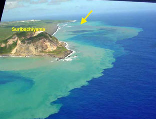
Ioto (Iwo-jima), located about 1,200 km S of Tokyo, lies within a 9-km-wide submarine caldera along the Izu-Bonin-Mariana volcanic arc. Previous eruptions date back to 1889 and have consisted of dominantly phreatic explosions, pumice deposits during 2001, and discolored water. A submarine eruption during July through December 2022 was characterized by discolored water, pumice deposits, and gas emissions (BGVN 48:01). This report covers a new eruption during October through December 2023, which consisted of explosions, black ejecta, discolored water, and floating pumice, based on information from the Japan Meteorological Association (JMA), the Japan Coast Guard (JCG), and satellite data.
JMA reported that an eruption had been occurring offshore of Okinahama on the SE side of the island since 21 October, which was characterized by volcanic tremor, according to the Japan Maritime Self-Defense Force (JMSDF) Iwo Jima Air Base (figure 22). According to an 18 October satellite image a plume of discolored water at the site of this new eruption extended NE (figure 23). During an overflight conducted on 30 October, a vent was identified about 1 km off the coast of Okinahama. Observers recorded explosions every few minutes that ejected dark material about 20 m above the ocean and as high as 150 m. Ejecta from the vent formed a black-colored island about 100 m in diameter, according to observations conducted from the air by the Earthquake Research Institute of the University of Tokyo in cooperation with the Mainichi newspaper (figure 24). Occasionally, large boulders measuring more than several meters in size were also ejected. Observations from the Advanced Land Observing Satellite Daichi-2 and Sentinel-2 satellite images also confirmed the formation of this island (figure 23). Brown discolored water and floating pumice were present surrounding the island.
 |
Figure 22. Map of Ioto showing the locations of recorded eruptions from 1889 through December 2023. The most recent eruption occurred during October through December 2023 and is highlighted in red just off the SE coast of the island and E of the 2001 eruption site. A single eruption highlighted in green was detected just off the NE coast of the island on 18 November 2023. From Ukawa et al. (2002), modified by JMA. |
 |
Figure 23. Satellite images showing the formation of the new island formation (white arrow) off the SE (Okinahama) coast of Ioto on 18 October 2023 (top left), 27 November 2023 (top right), 2 December 2023 (bottom left), and 12 December 2023 (bottom right). Discolored water was visible surrounding the new island. By December, much of the island had been eroded. Courtesy of Copernicus Browser. |
 |
Figure 24. Photo showing an eruption off the SE (Okinahama) coast of Ioto around 1230 on 30 October 2023. A column of water containing black ejecta is shown, which forms a new island. Occasionally, huge boulders more than several meters in size were ejected with the jet. Dark brown discolored water surrounded the new island. Photo has been color corrected and was taken from the S by the Earthquake Research Institute, University of Tokyo in cooperation of Mainichi newspaper. Courtesy of JMA. |
The eruption continued during November. During an overflight on 3 November observers photographed the island and noted that material was ejected 169 m high, according to a news source. Explosions gradually became shorter, and, by the 3rd, they occurred every few seconds; dark and incandescent material were ejected about 800 m above the vent. On 4 November eruptions were accompanied by explosive sounds. Floating, brown-colored pumice was present in the water surrounding the island. There was a brief increase in the number of volcanic earthquakes during 8-14 November and 24-25 November. The eruption temporarily paused during 9-11 November and by 12 November eruptions resumed to the W of the island. On 10 November dark brown-to-dark yellow-green discolored water and a small amount of black floating material was observed (figure 25). A small eruption was reported on 18 November off the NE coast of the island, accompanied by white gas-and-steam plumes (figure 23). Another pause was recorded during 17-19 November, which then resumed on 20 November and continued erupting intermittently. According to a field survey conducted by the National Institute for Disaster Prevention Science and Technology on 19 November, a 30-m diameter crater was visible on the NE coast where landslides, hot water, and gray volcanic ash containing clay have occurred and been distributed previously. Erupted blocks about 10 cm in diameter were distributed about 90-120 m from the crater. JCG made observations during an overflight on 23 November and reported a phreatomagmatic eruption. Explosions at the main vent generated dark gas-and-ash plumes that rose to 200 m altitude and ejected large blocks that landed on the island and in the ocean (figure 26). Discolored water also surrounded the island. The size of the new island had grown to 450 m N-S x 200 m E-W by 23 November, according to JCG.
 |
Figure 25. Photo of the new land formed off the SE (Okinahama) coast of Ioto on 10 November showing discolored water and a small amount of black floating material were visible surrounding the island. Photo has been color corrected. Photographed by JCG courtesy of JMA. |
 |
Figure 26. Photo of the new land formed off the SE (Okinahama) coast of Ioto on 23 November showing a phreatomagmatic eruption that ejected intermittent pulses of ash and dark material that rose to 200 m altitude. Photo has been color corrected. Photographed by JCG courtesy of JMA. |
The eruption continued through 11 December, followed by a brief pause in activity, which then resumed on 31 December, according to JMA. Intermittent explosions produced 100-m-high black plumes at intervals of several minutes to 30 minutes during 1-10 December. Overflights were conducted on 4 and 15 December and reported that the water surrounding the new island was discolored to dark brown-to-dark yellow-green (figure 27). No floating material was reported during this time. In comparison to the observations made on 23 November, the new land had extended N and part of it had eroded away. In addition, analysis by the Geospatial Information Authority of Japan using SAR data from Daichi-2 also confirmed that the area of the new island continued to decrease between 4 and 15 December. Ejected material combined with wave erosion transformed the island into a “J” shape, 500-m-long and with the curved part about 200 m offshore of Ioto. The island was covered with brown ash and blocks, and the surrounding water was discolored to greenish-brown and contained an area of floating pumice. JCG reported from an overflight on 4 December that volcanic ash-like material found around the S vent on the NE part of the island was newly deposited since 10 November (figure 28). By 15 December the N part of the “J” shaped island had separated and migrated N, connecting to the Okinahama coast and the curved part of the “J” had eroded into two smaller islands (figure 27).
 |
Figure 27. Photos of the new island formed off the SE (Okinahama) coast of Ioto on 4 December 2023 (left) and 15 December 2023 (right). No gas-and-ash emissions or lava flows were observed on the new land. Additionally, dark brown-to-dark yellow-green discolored water was observed surrounding the new land. During 4 and 15 December, the island had eroded to where the N part of the “J” shape had separated and migrated N, connecting to the Okinahama coast and the curved part of the “J” had eroded into two smaller islands. Courtesy of Copernicus Browser. |
 |
Figure 28. Photo of new volcanic ash-deposits (yellow dashed lines) near the S vent on the NE coast of Ioto taken by JCG on 4 December 2023. White gas-and-steam emissions were also visible (white arrow). Photo has been color corrected. Courtesy of JMA. |
References. Ukawa, M., Fujita, E., Kobayashi, T., 2002, Recent volcanic activity of Iwo Jima and the 2001 eruption, Monthly Chikyu, Extra No. 39, 157-164.
Geological Summary. Ioto, in the Volcano Islands of Japan, lies within a 9-km-wide submarine caldera. The volcano is also known as Ogasawara-Iojima to distinguish it from several other "Sulfur Island" volcanoes in Japan. The triangular, low-elevation, 8-km-long island narrows toward its SW tip and has produced trachyandesitic and trachytic rocks that are more alkalic than those of other volcanoes in this arc. The island has undergone uplift for at least the past 700 years, accompanying resurgent doming of the caldera; a shoreline landed upon by Captain Cook's surveying crew in 1779 is now 40 m above sea level. The Motoyama plateau on the NE half of the island consists of submarine tuffs overlain by coral deposits and forms the island's high point. Many fumaroles are oriented along a NE-SW zone cutting through Motoyama. Numerous recorded phreatic eruptions, many from vents on the W and NW sides of the island, have accompanied the uplift.
Information Contacts: Japan Meteorological Agency (JMA), 1-3-4 Otemachi, Chiyoda-ku, Tokyo 100-8122, Japan (URL: http://www.jma.go.jp/jma/indexe.html); Japan Coast Guard (JCG) Volcano Database, Hydrographic and Oceanographic Department, 3-1-1, Kasumigaseki, Chiyoda-ku, Tokyo 100-8932, Japan (URL: https://www1.kaiho.mlit.go.jp/GIJUTSUKOKUSAI/kaiikiDB/kaiyo22-2.htm); Copernicus Browser, Copernicus Data Space Ecosystem, European Space Agency (URL: https://dataspace.copernicus.eu/browser/); Asahi, 5-3-2, Tsukiji, Chuo Ward, Tokyo, 104-8011, Japan (URL: https://www.asahi.com/ajw/articles/15048458).