Report on Langila (Papua New Guinea) — December 1978
Scientific Event Alert Network Bulletin, vol. 3, no. 12 (December 1978)
Managing Editor: David Squires.
Langila (Papua New Guinea) Active lava dome; ash emission increases
Please cite this report as:
Global Volcanism Program, 1978. Report on Langila (Papua New Guinea) (Squires, D., ed.). Scientific Event Alert Network Bulletin, 3:12. Smithsonian Institution. https://doi.org/10.5479/si.GVP.SEAN197812-252010
Langila
Papua New Guinea
5.525°S, 148.42°E; summit elev. 1330 m
All times are local (unless otherwise noted)
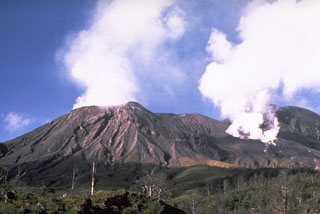
The character of activity changed in late October, after six strong explosions had occurred earlier in the month. Explosions became more frequent, but only a little ash was present in the eruption clouds. Ash contents increased on 27 November and remained high through December while frequent explosions persisted. Since 27 November, a gray ash plume has been continuously visible over the volcano.
Aerial inspections on 7 and 15 December revealed an active lava dome in Crater 2 (Langila's NE crater). Incandescence was visible in the dome's surface fissures during these (daytime) overflights. Glow could be seen at night from 10 km away on 13 and 21 December.
Geological Summary. Langila, one of the most active volcanoes of New Britain, consists of a group of four small overlapping composite basaltic-andesitic cones on the lower E flank of the extinct Talawe volcano in the Cape Gloucester area of NW New Britain. A rectangular, 2.5-km-long crater is breached widely to the SE; Langila was constructed NE of the breached crater of Talawe. An extensive lava field reaches the coast on the N and NE sides of Langila. Frequent mild-to-moderate explosive eruptions, sometimes accompanied by lava flows, have been recorded since the 19th century from three active craters at the summit. The youngest and smallest crater (no. 3 crater) was formed in 1960 and has a diameter of 150 m.
Information Contacts: C. McKee, RVO.

