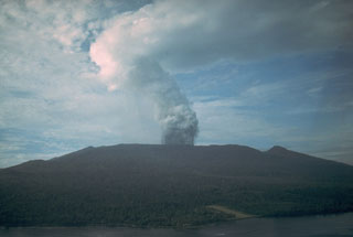
Report on Karkar (Papua New Guinea) — March 1979
Scientific Event Alert Network Bulletin, vol. 4, no. 3 (March 1979)
Managing Editor: David Squires.
Karkar (Papua New Guinea) Two volcanologists killed by explosion
Please cite this report as:
Global Volcanism Program, 1979. Report on Karkar (Papua New Guinea) (Squires, D., ed.). Scientific Event Alert Network Bulletin, 4:3. Smithsonian Institution. https://doi.org/10.5479/si.GVP.SEAN197903-251030
Karkar
Papua New Guinea
4.647°S, 145.976°E; summit elev. 1839 m
All times are local (unless otherwise noted)
We are saddened to report that R.J.S. Cooke, 40, and Elias Ravian, 34, were killed on 8 March by a directed blast of debris from Karkar volcano. Robin Cooke came to Rabaul Volcanological Observatory in 1971 and was named Senior Volcanologist two years later. His contributions to volcanology were many, particularly in seismic monitoring and in generously sharing his reports of local volcanism with scientists of the world. Elias Ravian had been a highly respected worker at the Observatory for 9 years. Both men devoted much of themselves to better understanding of the volcanism that took their lives.
The following is from a report by Richard Almond. Seismic activity at the caldera rim camp, about 1.2 km from the vent (figure 2), decreased slightly 1-2 March, then remained at a relatively low level through the 4th. Dense billows of white vapor from the vent were accompanied by occasional mild ash ejections on 1 March, but there was little or no ash emission 2-4 March. Seismicity increased gradually 5-7 March, but only one weak ash ejection, on the 5th, accompanied the continuing dense vapor emission.
At 0125 on 8 March, most of Karkar Island's 23,000 residents were awakened by the sound of a strong eruption. Continuous ejections of dense ash blanketed the W side of the island, where there were heavy ash and scoria falls for 45-60 minutes. Ash and blocks were scattered over the caldera floor. Accompanying the vertical eruption was a blast of hot gas and ejecta directed towards the SE. The blast devastated the entire SE quadrant of the caldera rim, killing Cooke and Ravian, who were camped near the S rim. Ash ejection, as observed from the coast, continued at a reduced level throughout 8 and 9 March. Seismic activity increased slightly during the major eruption, then decreased markedly.
Poor weather prevented observations on 10 and 11 March. From 12 to 16 March, aerial inspections revealed continuous emission of light brown ash from the NW portion of the vent, which had been enlarged by the 8 March eruption from 75 m to 300 m in diameter, and was about 150 m deep. Density of ash emission increased towards the end of the period,
On the 17th, emissions had changed to white vapor containing very little ash. Background seismicity was relatively low, but there were numerous discrete events, probably B-type. These had ceased by 0200 on the 18th and there was little or no vapor or ash. The source of previous emissions was then clearly visible; a cavern at the bottom of the crater extending in a NW direction beneath Bagiai Cone. There was a strong H2S smell when flying downwind of the volcano, even several kilometers from the vent. On 19 and 20 March, helicopter inspection revealed strong jets of vapor being emitted from the cavern with an extremely loud, continuous roaring noise. The angle of ejection was about 30° from the horizontal and toward the SE. These conditions continued until the morning of the 23rd, when a grey ash column was observed rising vertically from the vent. The ash cloud streamed to about 15 km SW of the island. Moderate ash emission continued through the end of March, accompanied by a moderately high level of harmonic tremor and periods of occasional B-type events.
McKee and others (1976) note that Bagiai "seems to have been the main source of recent activity, and was the source of the 1974 and 1975 eruptions".
Reference. McKee, C.O., Cooke, R.J.S., and Wallace, D.A., 1976, The 1974-75 eruptions of Karkar volcano, Papua New Guinea, in Johnson, R.W. (ed.), Volcanism in Australasia: Elsevier, p. 173-190.
Geological Summary. Karkar is a 19 x 25 km forest-covered island that is truncated by two nested summit calderas. The 5.5 km outer caldera was formed during one or more eruptions, the last of which occurred 9,000 years ago. The steep-walled 300-m-deep, 3.2 km diameter, inner caldera was formed sometime between 1,500 and 800 years ago. Cones are present on the N and S flanks of this basaltic-to-andesitic volcano; a linear array of small cones extends from the northern rim of the outer caldera nearly to the coast. Recorded eruptions date back to 1643 from Bagiai, a pyroclastic cone constructed within the inner caldera, the floor of which is covered by young, mostly unvegetated andesitic lava flows.
Information Contacts: R. Almond and C. McKee, RVO.

