Report on Karkar (Papua New Guinea) — June 1979
Scientific Event Alert Network Bulletin, vol. 4, no. 6 (June 1979)
Managing Editor: David Squires.
Karkar (Papua New Guinea) Heavy ashfall in W summit area; seismicity reaches highest level of 1979
Please cite this report as:
Global Volcanism Program, 1979. Report on Karkar (Papua New Guinea) (Squires, D., ed.). Scientific Event Alert Network Bulletin, 4:6. Smithsonian Institution. https://doi.org/10.5479/si.GVP.SEAN197906-251030
Karkar
Papua New Guinea
4.647°S, 145.976°E; summit elev. 1839 m
All times are local (unless otherwise noted)
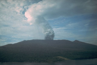
"Through most of June, a moderate-sized white vapour plume stood over the summit. This plume was usually 1-2 km long and rose 0.5 km above the crater. Surtseyan-like explosions of dark ejecta and vapours were seen from several vents in the crater floor on most days. These explosions were mainly contained within the 1979 crater, which now has horizontal dimensions of 450 x 300 m and is 300 m deep. The crater was significantly enlarged by the strong explosions at the end of May and beginning of June. Other periods of moderate to strong activity occurred on 8, 17, and 23 June. At these times continuous grey ash emissions formed an ash plume stretching for several kilometers, and heavy ashfall occurred on the W part of the summit region. Explosive sounds from the summit were heard on the W flank and coast during the stronger activity. Flashing arcs were seen on 16, 18, and 22 June. Horizontally moving ground-hugging clouds were seen advancing slowly from the crater rim in late May and early June, and on 23 June. Thin lobe-shaped deposits of ash about 100-200 m long were formed by the ash clouds on the W rim of the crater on 23 June. A pond of grey water was briefly visible in the bottom of the crater after the strong explosions. Sulfur deposits were present for several days after 20 June on the N and S walls of the 1979 crater, on the summit of Bagiai Cone, and on a small part of the W floor of the caldera, but these were obliterated by the strong ash eruptions of 23 June.
"A significant intensification of seismic activity commenced in mid- or late May and reached the highest sustained level for the year at mid-June."
Geological Summary. Karkar is a 19 x 25 km forest-covered island that is truncated by two nested summit calderas. The 5.5 km outer caldera was formed during one or more eruptions, the last of which occurred 9,000 years ago. The steep-walled 300-m-deep, 3.2 km diameter, inner caldera was formed sometime between 1,500 and 800 years ago. Cones are present on the N and S flanks of this basaltic-to-andesitic volcano; a linear array of small cones extends from the northern rim of the outer caldera nearly to the coast. Recorded eruptions date back to 1643 from Bagiai, a pyroclastic cone constructed within the inner caldera, the floor of which is covered by young, mostly unvegetated andesitic lava flows.
Information Contacts: C. McKee, RVO.

