Report on Karkar (Papua New Guinea) — July 1979
Scientific Event Alert Network Bulletin, vol. 4, no. 7 (July 1979)
Managing Editor: David Squires.
Karkar (Papua New Guinea) Explosive phases follow heavy rainfall; seismicity declines slightly
Please cite this report as:
Global Volcanism Program, 1979. Report on Karkar (Papua New Guinea) (Squires, D., ed.). Scientific Event Alert Network Bulletin, 4:7. Smithsonian Institution. https://doi.org/10.5479/si.GVP.SEAN197907-251030
Karkar
Papua New Guinea
4.647°S, 145.976°E; summit elev. 1839 m
All times are local (unless otherwise noted)
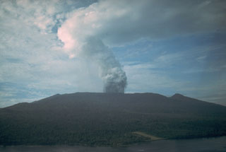
"For most of July the eruption remained at low intensity. Characteristically, a white vapour plume several kilometers long trailed away from the summit. A sulphurous odour was detected downwind from the new crater during early and late July. A haze of pale blue vapour was formed in the W part of the summit caldera on several days late in July.
"Ponds of grey water occupied the base of the new crater, and dark, Surtseyan-like explosions of solid ejecta, vapour, and water occurred at high frequency. Numerous different explosion sites were observed, although at some only mild intermittent bubbling was taking place.
"Stronger explosive activity occurred on 6, 9, and 15-16 July, when dark clouds of ash and rocks were ejected above the crater rim. Fields of impact craters were formed on the caldera floor to distances of several hundred meters from the rim of the crater. Most of the ash in these ejections fell in the W summit region, but weak ashfalls at the coast on 15 and 16 July were reported. An association between these explosive phases and prior heavy rainfalls is evident.
"The intensity of volcano-seismic activity declined slightly from the higher June level. Discrete volcanic earthquakes were recorded on many days, and bands of strong tremor were evident on a few days.
"Gravity and tilt measurements are continuing. Several caldera floor gravity stations have been irretrievably lost because of ashfalls and mudflows. A trend towards increasing gravity values on the caldera floor seems to have ceased, and two stations on the caldera rim are now showing values lower by a few hundredths of a mgal. Of the four tilt stations, only the two caldera rim ones are showing definite trends. These stations, on the S part of the summit, are showing downwards tilting in an approximately NW direction."
Geological Summary. Karkar is a 19 x 25 km forest-covered island that is truncated by two nested summit calderas. The 5.5 km outer caldera was formed during one or more eruptions, the last of which occurred 9,000 years ago. The steep-walled 300-m-deep, 3.2 km diameter, inner caldera was formed sometime between 1,500 and 800 years ago. Cones are present on the N and S flanks of this basaltic-to-andesitic volcano; a linear array of small cones extends from the northern rim of the outer caldera nearly to the coast. Recorded eruptions date back to 1643 from Bagiai, a pyroclastic cone constructed within the inner caldera, the floor of which is covered by young, mostly unvegetated andesitic lava flows.
Information Contacts: C. McKee, RVO.

