Report on Karkar (Papua New Guinea) — August 1979
Scientific Event Alert Network Bulletin, vol. 4, no. 8 (August 1979)
Managing Editor: David Squires.
Karkar (Papua New Guinea) Explosions continue
Please cite this report as:
Global Volcanism Program, 1979. Report on Karkar (Papua New Guinea) (Squires, D., ed.). Scientific Event Alert Network Bulletin, 4:8. Smithsonian Institution. https://doi.org/10.5479/si.GVP.SEAN197908-251030
Karkar
Papua New Guinea
4.647°S, 145.976°E; summit elev. 1839 m
All times are local (unless otherwise noted)
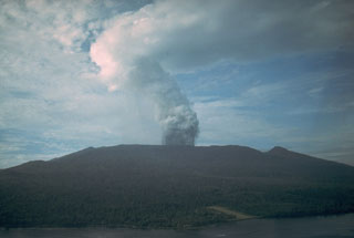
"During the first nine days of August, moderate explosive activity occurred. The heavier solid fragments in dark ejections were contained mainly within the crater, but on the lst blocks rose about 200 m above the crater rim, and some landed on the crater rim. Several vents were active but the most productive were those at the centre and the W extremity of the crater floor. Types of explosive activity, which varied from one vent to another, included frequent dense black convoluting ejections, grey ash-laden vapour emission, streaky black and white jets, and weaker grey-brown ash and vapour emission. Eruption sounds were not loud and ranged from low roaring and rumbling to banging. The emission cloud was usually grey, and sometimes brown, between the lst and 9th. Occasionally it rose to 500-800 m above the crater rim. Ashfalls in this period were largely restricted to the summit and were heaviest on the lst.
"Grey water was seen in a pond in the W extremity of the crater floor on the 4th, and from the 10th a lake covered most of the crater floor. Profuse steaming at the surface of the lake partly obscured the explosive activity. Ejections through the lake occasionally resembled surtseyan blasts, but commonly they only rose several tens of meters above the lake surface and had the appearance of water fountains.
"After the 9th the emission cloud consisted of white vapour in small to moderate volume. Sulphurous odours were noticed around and downwind from the crater for most of the month.
"Direct measurements of the crater on the 24th showed it to be 700 m long and 440 m wide, elongated in the E-W direction. No depth measurement was made but depth is estimated to be 300-400 m."
Further Reference. McKee, C.O., Wallace, D.A., Almond, R.A., and Talai, B., 1981, Fatal hydro-eruption of Karkar volcano in 1979: development of a maar-like crater, in Johnson, R.W. (ed.), Cooke-Ravian Volume of Volcanological Papers: Geological Survey of Papua New Guinea Memoir 10, p. 63-84.
Geological Summary. Karkar is a 19 x 25 km forest-covered island that is truncated by two nested summit calderas. The 5.5 km outer caldera was formed during one or more eruptions, the last of which occurred 9,000 years ago. The steep-walled 300-m-deep, 3.2 km diameter, inner caldera was formed sometime between 1,500 and 800 years ago. Cones are present on the N and S flanks of this basaltic-to-andesitic volcano; a linear array of small cones extends from the northern rim of the outer caldera nearly to the coast. Recorded eruptions date back to 1643 from Bagiai, a pyroclastic cone constructed within the inner caldera, the floor of which is covered by young, mostly unvegetated andesitic lava flows.
Information Contacts: C. McKee, RVO.

