Report on Karkar (Papua New Guinea) — May 1980
Scientific Event Alert Network Bulletin, vol. 5, no. 5 (May 1980)
Managing Editor: David Squires.
Karkar (Papua New Guinea) Weak eruptions through crater lake; inflation ends
Please cite this report as:
Global Volcanism Program, 1980. Report on Karkar (Papua New Guinea) (Squires, D., ed.). Scientific Event Alert Network Bulletin, 5:5. Smithsonian Institution. https://doi.org/10.5479/si.GVP.SEAN198005-251030
Karkar
Papua New Guinea
4.647°S, 145.976°E; summit elev. 1839 m
All times are local (unless otherwise noted)
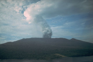
"Summit observations 10 May revealed that a small lake of brown water occupied the NW part of the 1979 crater. Silting had formed a flat crater floor some 300 m square. Near the centre of the crater floor was a circular pool of brown water about 25 m in diameter. Continuous upheavals of vapour, water, and dark crater floor material were observed rising only slightly above the level of the water surface. A line of fumaroles stretched W from this pool. Extensive weak fumarolic activity had deposited white and yellow sublimates over the lower 2/3 of the E crater wall, and diffuse vapour emission on the W side of the crater was slightly stronger. Vapour emission continued from sources on Bagiai Cone. Weak fumaroles extended in a line from the crater to the S caldera wall, and several others on the SW caldera floor were also observed.
"Gravity observations between 9 and 11 May were similar to previous sets in 1980, and suggested a cessation of inflation of the upper part of the volcano. Dry tilt observations seemed to agree with this trend. Seismic activity remained unchanged."
Geological Summary. Karkar is a 19 x 25 km forest-covered island that is truncated by two nested summit calderas. The 5.5 km outer caldera was formed during one or more eruptions, the last of which occurred 9,000 years ago. The steep-walled 300-m-deep, 3.2 km diameter, inner caldera was formed sometime between 1,500 and 800 years ago. Cones are present on the N and S flanks of this basaltic-to-andesitic volcano; a linear array of small cones extends from the northern rim of the outer caldera nearly to the coast. Recorded eruptions date back to 1643 from Bagiai, a pyroclastic cone constructed within the inner caldera, the floor of which is covered by young, mostly unvegetated andesitic lava flows.
Information Contacts: C. McKee, RVO.

