Report on Erebus (Antarctica) — March 1982
Scientific Event Alert Network Bulletin, vol. 7, no. 3 (March 1982)
Managing Editor: Lindsay McClelland.
Erebus (Antarctica) Lava lake level lower
Please cite this report as:
Global Volcanism Program, 1982. Report on Erebus (Antarctica) (McClelland, L., ed.). Scientific Event Alert Network Bulletin, 7:3. Smithsonian Institution. https://doi.org/10.5479/si.GVP.SEAN198203-390020
Erebus
Antarctica
77.53°S, 167.17°E; summit elev. 3794 m
All times are local (unless otherwise noted)
"The summit crater was visited by New Zealand and U.S. scientists during late November and December 1981, and on one day in late January 1982. The anorthoclase phonolite lava lake was still present and the pattern of activity was similar to that observed over the last 5 years.
"The lake was undergoing simple convection. Small Strombolian explosions continued at a frequency of 4-6/day. The eruptions were believed to originate from the Active Vent, adjacent to the lava lake. Many fresh bomb were found on the crater rim, suggesting that the eruptions were the strongest observed in the last 3 years. This may reflect an increase in distance between the lip of the Active Vent and the underlying magma level.
"The lava lake grew from small hornitos in 1972 to a semi-circular lake ~100 m long by 1976. Since then there has been little change in surface area, but a slight lowering in the lake level has occurred. No measurements of the magma column withdrawal were available but it was small, perhaps 5-10 m over the last 3 years. The withdrawal was possibly equivalent to the amount of material ejected by the small Strombolian eruptions. A deformation survey pattern set up in December 1980 was remeasured in December 1981; . . . data indicate [little change in the width] of the crater rim, [despite the] lowering of the column. Withdrawal was [however] suggested by the development of a semi-radial fracture, on the main crater floor, that parallels the inner crater rim."
Further References. Dibble, R.R., Kienle, J., Kyle, P.R., and Shibuya, K., 1984, Geophysical studies of Erebus volcano, Antarctica, from 1974 December to 1982 January, in Lynch, R.P. (ed.), Tenth Antarctic Issue: New Zealand Journal of Geology and Geophysics, v. 27, no. 4, p. 425-455.
Wiesnet, D.R., and D'Aguanno, J., 1982, Thermal imagery of Mount Erebus from the NOAA-6 satellite: Antarctic Journal of the United States, v. 17, no. 5, p. 32-34.
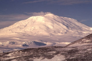
Geological Summary. Mount Erebus overlooks the McMurdo research station on Ross Island and is the largest of three major volcanoes forming the roughly triangular Ross Island. The summit of the dominantly phonolitic volcano has been modified by one or two generations of caldera formation. A summit plateau at about 3,200 m elevation marks the rim of the youngest caldera, which formed during the late-Pleistocene and within which the modern cone was constructed. An elliptical 500 x 600 m, 110-m-deep crater truncates the summit and contains an active lava lake within a 250-m-wide, 100-m-deep inner crater; other lava lakes are sometimes present. The glacier-covered volcano was erupting when first sighted by Captain James Ross in 1841. A persistent lava-lake, with minor explosions punctuated by occasional larger Strombolian explosions that eject bombs onto the crater rim, has been documented since 1972, but nearly continuous activity has probably been occurring for much longer.
Information Contacts: P. Kyle, New Mexico Inst. of Mining & Tech.; P. Otway, NZGS, Wairakei.

