Report on Lopevi (Vanuatu) — October 1982
Scientific Event Alert Network Bulletin, vol. 7, no. 10 (October 1982)
Managing Editor: Lindsay McClelland.
Lopevi (Vanuatu) Ash emission
Please cite this report as:
Global Volcanism Program, 1982. Report on Lopevi (Vanuatu) (McClelland, L., ed.). Scientific Event Alert Network Bulletin, 7:10. Smithsonian Institution. https://doi.org/10.5479/si.GVP.SEAN198210-257050
Lopevi
Vanuatu
16.507°S, 168.346°E; summit elev. 1413 m
All times are local (unless otherwise noted)
A. Macfarlane reported that Lopevi ejected a black ash cloud on 24 October that rose to an altitude of about 6 km and drifted NW. Weather clouds prevented satellite observations until late that day, when no plume was visible. On 25 October, the area's first daylight image (at 0645) from the GOES West geostationary weather satellite showed a relatively diffuse plume extending about 250 km S from the volcano. By 0900, the far end of the cloud was roughly 500 km S of Lopevi and feeding appeared to be ending. The cloud had clearly begun to dissipate on the next image, an hour later. As of early November, no additional activity had been reported either in Vanuatu or by Solair pilots (who fly near Lopevi three days a week). Macfarlane notes that such activity at Lopevi is not unusual. Lopevi was last reported active on 12 September 1979, when small amounts of ash were emitted from cones on the SW flank.
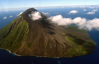
Geological Summary. The small 7-km-wide conical island of Lopevi, known locally as Vanei Vollohulu, is one of Vanuatu's most active volcanoes. A small summit crater containing a cinder cone is breached to the NW and tops an older cone that is rimmed by the remnant of a larger crater. The basaltic-to-andesitic volcano has been active during historical time at both summit and flank vents, primarily along a NW-SE-trending fissure that cuts across the island, producing moderate explosive eruptions and lava flows that reached the coast. Historical eruptions at the 1413-m-high volcano date back to the mid-19th century. The island was evacuated following major eruptions in 1939 and 1960. The latter eruption, from a NW-flank fissure vent, produced a pyroclastic flow that swept to the sea and a lava flow that formed a new peninsula on the western coast.
Information Contacts: A. Macfarlane, Geological Survey, Vanuatu; F. Coulson, Ministry of Natural Resources, Solomon Islands; D. Haller, NOAA/NESS; R. Shaw, IATA.

