Report on Ol Doinyo Lengai (Tanzania) — February 1983
Scientific Event Alert Network Bulletin, vol. 8, no. 2 (February 1983)
Managing Editor: Lindsay McClelland.
Ol Doinyo Lengai (Tanzania) Tephra emission continues; lava flow
Please cite this report as:
Global Volcanism Program, 1983. Report on Ol Doinyo Lengai (Tanzania) (McClelland, L., ed.). Scientific Event Alert Network Bulletin, 8:2. Smithsonian Institution. https://doi.org/10.5479/si.GVP.SEAN198302-222120
Ol Doinyo Lengai
Tanzania
2.764°S, 35.914°E; summit elev. 2962 m
All times are local (unless otherwise noted)
Satellite images and reports from the ground indicated that the activity continued through early March with varying intensity. Imagery from the NOAA 7 polar orbiter showed a small plume over the crater on most days. Although larger than most observed in February, a plume on the 9th appeared to be at low altitude and extended less than 10 km NNE. On 2 March, a plume was visible to 80-100 km E of the volcano. Low-level winds were blowing in the opposite direction, but those at 6-7.5 km were moving toward the E at about 10 km per hour. Dennis Haller noted, however, that weather stations in the area are widely separated and that low-velocity winds are often quite variable in direction. On 8 March, the plume extended less than 50 km NE, again in the wrong direction for the low-altitude winds observed elsewhere in the region.
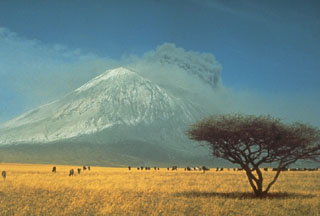
Tanzania National Park Service officials in Arusha (roughly 120 km SE of the volcano) reported that during activity on 2 February, an eruption column and incandescence could be seen 150 km away. A second eruption occurred 19 February, and as of early March activity was said to be occasional. The active vent was described as "inside the cone." Most eruptions in this century have been from the N crater, which contained a tiny hornito when Maurice Krafft climbed the volcano in 1980. Evidence of flowing lava along the road nearest the volcano was also reported. A passenger aboard a commercial airliner (date of flight unknown) saw lava flowing from the back of the crater and bubbling inside. Peter Swan and Peter Jones reported fine ash around Olduvai (~70 km from the volcano) 14 February. Jones noted that visibility was limited and there was a constant odor of volcanic fume. From Magadi, Kenya (130 km N of Ol Doinyo Lengai), P. R. Ellis saw small plumes rising from the volcano's W side at the beginning of March and noted that there had been several other observations of activity from the Magadi area.
Ol Doinyo Lengai's most recent reported eruption was August-September 1974, when it ejected tephra from the N crater.
Geological Summary. The symmetrical Ol Doinyo Lengai is the only volcano known to have erupted carbonatite tephras and lavas in historical time. The prominent stratovolcano, known to the Maasai as "The Mountain of God," rises abruptly above the broad plain south of Lake Natron in the Gregory Rift Valley. The cone-building stage ended about 15,000 years ago and was followed by periodic ejection of natrocarbonatitic and nephelinite tephra during the Holocene. Historical eruptions have consisted of smaller tephra ejections and emission of numerous natrocarbonatitic lava flows on the floor of the summit crater and occasionally down the upper flanks. The depth and morphology of the northern crater have changed dramatically during the course of historical eruptions, ranging from steep crater walls about 200 m deep in the mid-20th century to shallow platforms mostly filling the crater. Long-term lava effusion in the summit crater beginning in 1983 had by the turn of the century mostly filled the northern crater; by late 1998 lava had begun overflowing the crater rim.
Information Contacts: D. Haller, NOAA/NESDIS; Natl. Park Service, Tanzania; D. Miller, U.S. Embassy, Dar es Salaam; P. Swan, Arusha; P. Jones, Ngorongoro; P. Ellis, Magadi, Kenya; M. Krafft, Cernay; R. Hay, Univ. of California, Berkeley.

