Report on Soufriere Guadeloupe (France) — March 1983
Scientific Event Alert Network Bulletin, vol. 8, no. 3 (March 1983)
Managing Editor: Lindsay McClelland.
Soufriere Guadeloupe (France) Water temperatures and chemistry
Please cite this report as:
Global Volcanism Program, 1983. Report on Soufriere Guadeloupe (France) (McClelland, L., ed.). Scientific Event Alert Network Bulletin, 8:3. Smithsonian Institution. https://doi.org/10.5479/si.GVP.SEAN198303-360060
Soufriere Guadeloupe
France
16.044°N, 61.664°W; summit elev. 1467 m
All times are local (unless otherwise noted)
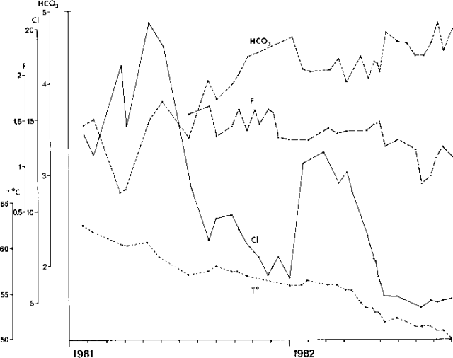
A study of the geochemical evolution of Carbet l'Echelle spring, continued during 1981 and 1982 (figure 10). The water temperature decreased from 62.5°C in January 1981 to 50° in September 1982, while the concentration of HCO3 ions continued to increase (+ 30%). Moreover, although large variations in Cl concentration have been observed since 1979, the background level of Cl began to fall in September 1981 and was reduced by half in one year. Likewise, the concentration of F ions, which has oscillated around a constant value since the beginning of the survey, decreased slightly in late 1982. Water temperatures and chemistry remained nearly constant at the other springs monitored by this study.
Further References: Bigot, S., and Hammouya, G., 1987, Surveillance hydrogéochimique de la Soufrière de Guadeloupe, 1979-1985: Diminuition d'activité ou confinement?: C.R. Acad. Sci. Paris, t. 304, Série II, no. 13, p. 757-760.
Observations volcanologiques: Rapport d'Activité des Observatoires Volcanologiques des Antilles (Guadeloupe-Martinique) - November 1976-April 1977, April 1977-December 1978, 1979, 1980, 1981, 1982, and 1983-1984: Institut de Physique du Globe, Paris.
Geological Summary. La Soufrière de la Guadeloupe volcano occupies the southern end of Basse-Terre, the western half of the island of Guadeloupe. Construction of the Grand Découverte volcano about 200,000 years ago was followed a Plinian eruption and caldera formation about 100,000 years later, and then by construction of the Carmichaël volcano within the caldera. Two episodes of edifice collapse and associated large debris avalanches formed the Carmichaël and Amic craters about 11,500 and 3,100 years ago, respectively. The present volcano subsequently grew within the Amic crater. The summit consists of a flat-topped lava dome, and several other domes occur on the southern flanks. Six phreatic explosive eruptions since 1690 opened radial fractures across the summit lava dome. The phreatic eruptions in 1976-77 caused severe economic disruption when Basse-Terre, the island's capital city immediately below the volcano, was evacuated.
Information Contacts: S. Bigot, Lab. de Géochemie, Paris; G. Hammouya, Lab. de Physique du Globe; J. Le Mouel, J. Cheminée, IPG, Paris.


