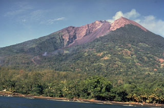
Report on Manam (Papua New Guinea) — September 1983
Scientific Event Alert Network Bulletin, vol. 8, no. 9 (September 1983)
Managing Editor: Lindsay McClelland.
Manam (Papua New Guinea) Four days of stronger activity, ashfalls to 10 km
Please cite this report as:
Global Volcanism Program, 1983. Report on Manam (Papua New Guinea) (McClelland, L., ed.). Scientific Event Alert Network Bulletin, 8:9. Smithsonian Institution. https://doi.org/10.5479/si.GVP.SEAN198309-251020
Manam
Papua New Guinea
4.08°S, 145.037°E; summit elev. 1807 m
All times are local (unless otherwise noted)
"Apart from a short period of stronger activity at mid-September, Manam continued its mild eruptive activity which has been characterized by moderate emissions of pale grey-brown ash clouds from both craters. The stronger activity occurred 10-13 September, when impulsive ejections of dark tephra-laden clouds took place from Southern crater at intervals of several minutes. The ejections rose to 150 m above the crater and fed a plume that extended several tens of kilometers downwind. However, this stronger activity had no distinctive seismic expression. Throughout the month amplitudes of volcanic earthquakes remained steady at 2-3 times normal, and the average daily total of events was about 2,500. Tilt measurements from Tabele Observatory indicated a gradually accumulating [upward tilt] of about 2 µrad to the NNW."
Richard Stoiber, Stanley Williams, and Chris McKee used a COSPEC to measure the rate of SO2 emission from several volcanoes in Papua New Guinea during September (table 1). Plumes at and Manam were strong, and plume was small. Activity at Langila was weak 11 September, but had intensified during measurements the next day. The quiet-phase data were collected from the ground; all other data were acquired while flying under the plumes.
Table 1. Rates of SO2 emission at Bagana, Langila, Manam, and Ulawun, Papua New Guinea, September 1983. Airborne COSPEC data from R. Stoiber, S. Williams, and C. McKee.
| Date | Volcano | SO2 t/d |
| 08 Sep 1983 | Bagana | 3,100 |
| 11 Sep 1983 | Langila | 74 |
| 11 Sep 1983 | Ulawun | 71 |
| 12 Sep 1983 | Langila | 1,300 |
| 12 Sep 1983 | Manam | 920 |
Geological Summary. The 10-km-wide island of Manam, lying 13 km off the northern coast of mainland Papua New Guinea, is one of the country's most active volcanoes. Four large radial valleys extend from the unvegetated summit of the conical basaltic-andesitic stratovolcano to its lower flanks. These valleys channel lava flows and pyroclastic avalanches that have sometimes reached the coast. Five small satellitic centers are located near the island's shoreline on the northern, southern, and western sides. Two summit craters are present; both are active, although most observed eruptions have originated from the southern crater, concentrating eruptive products during much of the past century into the SE valley. Frequent eruptions, typically of mild-to-moderate scale, have been recorded since 1616. Occasional larger eruptions have produced pyroclastic flows and lava flows that reached flat-lying coastal areas and entered the sea, sometimes impacting populated areas.
Information Contacts: C. McKee, RVO; R. Stoiber and S. Williams, Dartmouth College.

