Report on Veniaminof (United States) — December 1983
Scientific Event Alert Network Bulletin, vol. 8, no. 12 (December 1983)
Managing Editor: Lindsay McClelland.
Veniaminof (United States) Vapor plumes; incandescence; earthquakes
Please cite this report as:
Global Volcanism Program, 1983. Report on Veniaminof (United States) (McClelland, L., ed.). Scientific Event Alert Network Bulletin, 8:12. Smithsonian Institution. https://doi.org/10.5479/si.GVP.SEAN198312-312070
Veniaminof
United States
56.17°N, 159.38°W; summit elev. 2507 m
All times are local (unless otherwise noted)
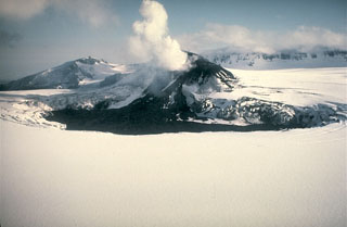
Eruptive activity was continuing in early January. Perryville residents saw glow over the volcano on the night of 9 December. On the 10th, a small vapor cloud rose from the summit area, and on the 11th a larger cloud rose to more than 4 km altitude. During the night of 26 December, they observed incandescent material being ejected from the summit area. Ash and vapor erupted from a vent on the intra-caldera cone and another to the SW. Earthquakes were felt in Perryville at 1045 on 26 December and 1415 on 27 December. On 8 January, Perryville residents saw an ashy vapor cloud rise from the intra-caldera cone, but they saw no glow over the volcano. Bad weather has prevented any overflights by USGS personnel since 4 November.
Further Reference. Yount, M.E., Miller, T.P., and others, 1985, Eruption in an ice-filled caldera, Mount Veniaminof, Alaska Peninsula: USGS Circular 945, p. 59-60.
Geological Summary. Veniaminof, on the Alaska Peninsula, is truncated by a steep-walled, 8 x 11 km, glacier-filled caldera that formed around 3,700 years ago. The caldera rim is up to 520 m high on the north, is deeply notched on the west by Cone Glacier, and is covered by an ice sheet on the south. Post-caldera vents are located along a NW-SE zone bisecting the caldera that extends 55 km from near the Bering Sea coast, across the caldera, and down the Pacific flank. Historical eruptions probably all originated from the westernmost and most prominent of two intra-caldera cones, which rises about 300 m above the surrounding icefield. The other cone is larger, and has a summit crater or caldera that may reach 2.5 km in diameter, but is more subdued and barely rises above the glacier surface.
Information Contacts: M.E. Yount, USGS, Anchorage.

