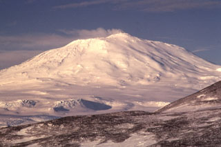
Report on Erebus (Antarctica) — January 1984
Scientific Event Alert Network Bulletin, vol. 9, no. 1 (January 1984)
Managing Editor: Lindsay McClelland.
Erebus (Antarctica) Dimensions of active lava lake from photo data; seismicity normal; SO2 flux measured
Please cite this report as:
Global Volcanism Program, 1984. Report on Erebus (Antarctica) (McClelland, L., ed.). Scientific Event Alert Network Bulletin, 9:1. Smithsonian Institution. https://doi.org/10.5479/si.GVP.SEAN198401-390020
Erebus
Antarctica
77.53°S, 167.17°E; summit elev. 3794 m
All times are local (unless otherwise noted)
"Volcanic activity at Mt. Erebus was observed in November and December 1983 by scientists from New Zealand and the U.S. The persistent convecting anorthoclase phonolite lava lake still existed and displayed activity similar to that observed over the last few years. Since 1976 its surface area has remained relatively constant. A recent airphoto showing the lava lake allowed a more precise determination of its size. The photo showed that the lake was ovoid and ~60 m long by ~45 m wide, considerably smaller than other ground-based observations have suggested.
"It has been previously reported that the level of the lava lake was dropping. A recent analysis of ground-based photographs makes it difficult to confirm a substantial lowering in the lake surface relative to other features seen on the Inner Crater floor. A small amount of lowering was documented in the 1979-80 austral summer field season, when a distinct bench with fumaroles rimmed the lake. However, the volcanic gas plume from the lake makes it extremely difficult to determine the lava lake height using simple visual estimates from the crater rim. Deformation studies currently in progress by NZGS personnel should give a better indication of the changes in the lava lake.
"The seismic network on Mt. Erebus was expanded by University of Alaska and Japanese personnel. Six radio-telemetry stations consisting of a single vertical-component seismometer are now situated on the flanks of the mountain. An additional station near the summit is presently inoperative. Three other stations are placed at sites 30-40 km from the summit of Mt. Erebus. Preliminary analysis of the seismic records show the level of seismicity to be normal.
"Airborne observations made using a C130 aircraft included sampling the plume for particle size distribution, and remote sensing using a COSPEC to determine SO2 flux, which was 230 ± 90 t/d [on 19 December]."
Further Reference. Chuan, R.L., Palais, J., and Rose, W.I., 1986, Fluxes, sizes, morphology, and compositions of particles in the Mt. Erebus volcanic plume, December 1983: Journal of Atmospheric Chemistry, v. 4, p. 467-477.
Geological Summary. Mount Erebus, the world's southernmost historically active volcano, overlooks the McMurdo research station on Ross Island. It is the largest of three major volcanoes forming the crudely triangular Ross Island. The summit of the dominantly phonolitic volcano has been modified by one or two generations of caldera formation. A summit plateau at about 3,200 m elevation marks the rim of the youngest caldera, which formed during the late-Pleistocene and within which the modern cone was constructed. An elliptical 500 x 600 m wide, 110-m-deep crater truncates the summit and contains an active lava lake within a 250-m-wide, 100-m-deep inner crater; other lava lakes are sometimes present. The glacier-covered volcano was erupting when first sighted by Captain James Ross in 1841. Continuous lava-lake activity with minor explosions, punctuated by occasional larger Strombolian explosions that eject bombs onto the crater rim, has been documented since 1972, but has probably been occurring for much of the volcano's recent history.
Information Contacts: P. Kyle, New Mexico Inst. of Mining & Tech.; W. Rose, Michigan Tech. Univ.

