Report on St. Helens (United States) — November 1985
Scientific Event Alert Network Bulletin, vol. 10, no. 11 (November 1985)
Managing Editor: Lindsay McClelland.
St. Helens (United States) New lahar warning gauge; background activity
Please cite this report as:
Global Volcanism Program, 1985. Report on St. Helens (United States) (McClelland, L., ed.). Scientific Event Alert Network Bulletin, 10:11. Smithsonian Institution. https://doi.org/10.5479/si.GVP.SEAN198511-321050
St. Helens
United States
46.2°N, 122.18°W; summit elev. 2549 m
All times are local (unless otherwise noted)
Mt. St. Helens was quiet through November and early December, with seismic activity, SO2 emission, and displacement rates remaining at background levels. Displacement rates on the dome were less than 1 mm/day; SO2 levels continued to be low and quite variable.
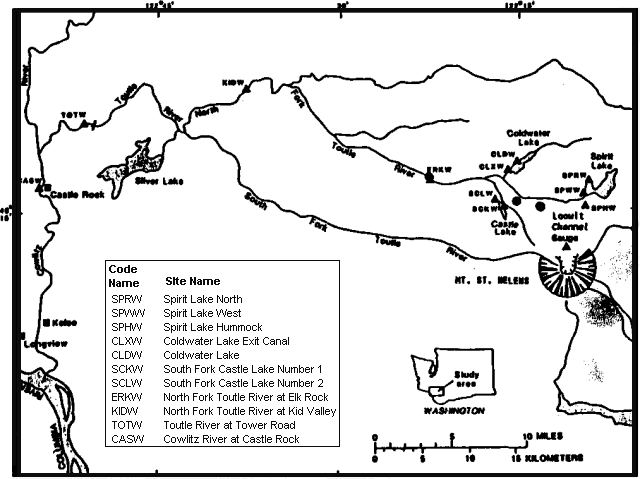
The USGS's Water Resources Division has installed a new gauge along the crater's main drainage channel to improve warnings of mudflows and snow avalanches. The new gauge, just N of the crater (in Loowit Channel at The Steps), and an existing one 25 km downstream in the North Fork Toutle River (at Elk Rock) transmit to CVO via satellite every 5 minutes. These stations, in addition to seismometers and other gauges downstream, should provide an early warning of rapidly rising water levels (figure 29).
 |
Figure 29. Location of monitoring sites, Mt. St. Helens, Washington; circles indicate seismometers, triangles indicate gauges. Base map modified from Childers and Carpenter, 1985. |
Much of the network was installed prior to November 1982 to monitor levels of the lakes created when the 18 May 1980 avalanche blocked the outflow from Spirit Lake and downstream tributaries to the North Fork Toutle River. Major flooding could occur if one of the debris dams failed, and seismometers were installed in 1983 to supplement the gauges. A characteristic signature is produced by lahars flowing from the crater in a confined channel, as in May and June 1984. Although exact times and discharge volumes could not be determined from the seismic records for those events, future refinements may provide a relationship between seismic signals and discharge volumes (Brantley and others, 1985).
References. Brantley, S., Power, J., and Topinka, L., 1985, Reports from the U.S. Geological Survey's Cascades Volcano Observatory at Vancouver, Washington; Earthquake Information Bulletin, v. 17, no. 1, p. 20-32.
Childers, D. and Carpenter, P.J., 1985, International Symposium on Erosion, Debris Flow, and Disaster Prevention; September 3-5, Tsukuba, Japan.
Geological Summary. Prior to 1980, Mount St. Helens was a conical volcano sometimes known as the Fujisan of America. During the 1980 eruption the upper 400 m of the summit was removed by slope failure, leaving a 2 x 3.5 km breached crater now partially filled by a lava dome. There have been nine major eruptive periods beginning about 40-50,000 years ago, and it has been the most active volcano in the Cascade Range during the Holocene. Prior to 2,200 years ago, tephra, lava domes, and pyroclastic flows were erupted, forming the older edifice, but few lava flows extended beyond the base of the volcano. The modern edifice consists of basaltic as well as andesitic and dacitic products from summit and flank vents. Eruptions in the 19th century originated from the Goat Rocks area on the N flank, and were witnessed by early settlers.
Information Contacts: G. Gallino, S. Brantley, E. Iwatsubo, USGS CVO, Vancouver, WA; C. Jonientz-Trisler, University of Washington.

