Report on Guagua Pichincha (Ecuador) — September 1988
Scientific Event Alert Network Bulletin, vol. 13, no. 9 (September 1988)
Managing Editor: Lindsay McClelland.
Guagua Pichincha (Ecuador) Increased seismicity; fumarolic activity slightly stronger
Please cite this report as:
Global Volcanism Program, 1988. Report on Guagua Pichincha (Ecuador) (McClelland, L., ed.). Scientific Event Alert Network Bulletin, 13:9. Smithsonian Institution. https://doi.org/10.5479/si.GVP.SEAN198809-352020
Guagua Pichincha
Ecuador
0.171°S, 78.598°W; summit elev. 4784 m
All times are local (unless otherwise noted)
Local seismicity has increased substantially since mid-April, accompanied by minor changes in the summit crater's fumarole field. Seismicity gradually built from background levels of 5-10/month to >200/month by August, and was continuing in early October. August and September events were centered at 4-9 km depth (most 7-9 km) near and N of the S caldera wall. In late September and early October seismicity migrated N toward the modern vent and upward, with some foci as shallow as 1.5 km. All were A-type shocks. Magnitudes of the largest events reached 3-3.5 and a few were felt in . . . Quito . . . . Early October data from tilt stations and EDM lines showed no deformation above noise levels since the last measurements in 1987. Geologists climbed the volcano on 8 October and noted more vigorous activity at existing fumaroles, plus new vents, an expansion in the size of the fumarole field, and recently killed vegetation.
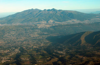
Geological Summary. Guagua Pichincha and the older Pleistocene Rucu Pichincha stratovolcanoes form a broad volcanic massif that rises immediately W of Ecuador's capital city, Quito. A lava dome grew at the head of a 6-km-wide scarp formed during a late-Pleistocene slope failure ~50,000 years ago. Subsequent late-Pleistocene and Holocene eruptions from the central vent consisted of explosive activity with pyroclastic flows accompanied by periodic growth and destruction of the lava dome. Many minor eruptions have been recorded since the mid-1500's; the largest took place in 1660, when ash fell over a 1,000 km radius and accumulated to 30 cm depth in Quito. Pyroclastic flows and surges also occurred, primarily to then W, and affected agricultural activity.
Information Contacts: M. Hall and H. Yépez, Instituto Geofísico de la Escuela Politécnica Nacional; N. Banks and J. Ewert, USGS.

