Report on Liamuiga (Saint Kitts and Nevis) — October 1988
Scientific Event Alert Network Bulletin, vol. 13, no. 10 (October 1988)
Managing Editor: Lindsay McClelland.
Liamuiga (Saint Kitts and Nevis) Earthquake swarm
Please cite this report as:
Global Volcanism Program, 1988. Report on Liamuiga (Saint Kitts and Nevis) (McClelland, L., ed.). Scientific Event Alert Network Bulletin, 13:10. Smithsonian Institution. https://doi.org/10.5479/si.GVP.SEAN198810-360030
Liamuiga
Saint Kitts and Nevis
17.37°N, 62.8°W; summit elev. 1156 m
All times are local (unless otherwise noted)
An earthquake swarm in the vicinity of Mt. Liamuiga began on 24 October and had declined by early November.
"The volcano is monitored by a single short-period seismograph station 8 km SE of the crater (SKI, figure 1). A second station (NEV) is 35 km to the SE and there are four other stations within 80 km of the volcano. The stations have been operating since 1952/53 and since 1980 have been linked by radio telemetry to the Seismic Research Unit, 700 km to the S. Data transmission is by standard analog techniques but data are recorded digitally using IBM PC-AT microcomputers. Since SKI was installed in 1953 it has recorded occasional microearthquakes with S-P intervals <2 seconds. These earthquakes show impulsive arrivals and clear P and S phases. They may possibly be small tectonic earthquakes but it is more likely that they are A-type volcanic earthquakes associated with Mt. Liamuiga. Normally, one or two are recorded each month.
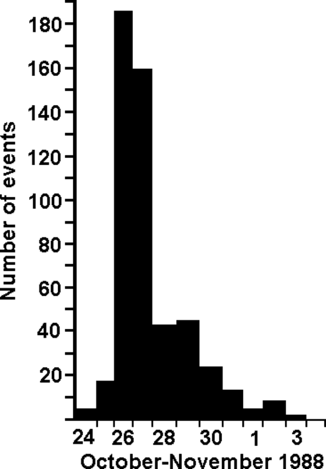
"On 24 October, a swarm of these events began and built up rapidly, peaking on 26 October when 186 earthquakes were recorded (figure 2). Many of the earthquakes were felt on St. Kitts and they caused great alarm. John Shepherd carried out an intensity survey on the morning of 27 October. At least five earthquakes were felt by all on St. Kitts. The most severe earthquakes up to that time were at 1201 and 1824 GMT on 26 October, with estimated magnitudes (mb) of 4.3 and 4.5. Both were felt throughout St. Kitts at up to MM VI and caused minor damage to weak masonry. They were also felt on the neighbouring islands of Nevis, Saba, Antigua, and Saint Maarten. Other earthquakes have been reported felt, mainly in the settlements on the flanks of Mt. Liamuiga. A party of tourists was visiting the crater of Mt. Liamuiga at the time of the second large earthquake. They reported that it was difficult to stand and that numerous small landslides were generated on the inner and outer walls of the crater.
 |
Figure 2. Daily numbers of earthquakes near Mt. Liamuiga (S-P intervals <3 seconds) recorded by station SKI beginning 24 October 1988. Courtesy of UWI. |
"Figure 1 shows epicenters of the two biggest earthquakes and 10 others that were sufficiently well recorded for estimates to be made. Focal depths of all events were in the 10-20 km range (mean 15 km). Clearly, the number and distribution of the stations in operation when the earthquakes began were not ideal for the location of the smaller events, so these epicenters are subject to uncertainties of the order of 5 km. To reduce these uncertainties, Lloyd Lynch added three extra stations to the network (BSK, SKDB, and SENA) on 29-30 October. Data from these stations are now being analyzed.
"It is too early to say whether this earthquake swarm has any direct connection with Mt. Liamuiga. It is still possible that they are of tectonic origin. However, the characteristics of the swarm are similar to those of previous volcanic earthquake swarms in other islands of the Lesser Antilles. Many of these swarms have occurred, particularly in the islands of Nevis, Montserrat, Dominica, Guadeloupe, and St. Vincent. Only a small proportion of these swarms have culminated in volcanic eruptions, but on the other hand, almost all eruptions have been preceded by earthquake swarms. This is the first known swarm in St. Kitts and the situation will be carefully monitored."
Geological Summary. Mount Liamuiga volcano, comprising the NW end of St. Kitts Island, contains a steep-walled, 1-km-wide summit crater, which contained a shallow lake until 1959. Two lava domes are located on the upper W flank, and intrusion of a 3rd dome, Brimstone Hill, on the lower SW flank uplifted a Pleistocene limestone block. Liamuiga, sometimes referred to as Mount Misery, is the youngest of three NW-migrating volcanic centers on St. Kitts. Its most recent major eruptions less than 2,000 years ago produced pyroclastic flows and mudflows whose deposits underlie populated coastal areas. Reports of possible eruptions in 1692 and 1843 are considered uncertain. An earthquake swarm from late 1988 to early 1989 caused small landslides in the summit crater; another earthquake swarm took place in 1999-2000. Active fumaroles are found in the summit crater.
Information Contacts: J. Shepherd, L. Lynch, and K. Rowley, UWI.


