Report on Arenal (Costa Rica) — June 1989
Scientific Event Alert Network Bulletin, vol. 14, no. 6 (June 1989)
Managing Editor: Lindsay McClelland.
Arenal (Costa Rica) 1987-89 explosive activity described
Please cite this report as:
Global Volcanism Program, 1989. Report on Arenal (Costa Rica) (McClelland, L., ed.). Scientific Event Alert Network Bulletin, 14:6. Smithsonian Institution. https://doi.org/10.5479/si.GVP.SEAN198906-345033
Arenal
Costa Rica
10.463°N, 84.703°W; summit elev. 1670 m
All times are local (unless otherwise noted)
A cooperative study of Arenal by the OVSICORI and the SI, assisted by Earthwatch and Smithsonian Research Expedition volunteers, has completed eight periods of continuous day/night monitoring, generally of 10-14 days each, in the past 2 years. Most of the observations were made from the Arenal Volcanological and Biological Observatory, 2.7 km S of the summit, on the Marigold Genis macademia plantation. The following is excerpted from a report by W. Melson. A more detailed version will be published in Boletín de Vulcanología [see Further Reference, below].
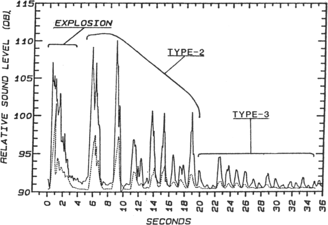
"Over the past 2 years, Arenal's eruptions include the infrequent emission of lava flows and a variety of frequent pyroclastic eruptions that can be classified into three overlapping and sometimes sequential event types. Sounds were recorded at the Observatory using a standard cassette recorder and directional microphone. We also used a sound-level meter and a strip recorder to obtain time-sound intensity records of eruptions. Only rarely is Arenal's summit visible. Thus, we normally must classify eruptions by their sound characteristics (figure 20).
1. Explosions are intense, brief, energy releases, usually
2. Long-duration eruptions of blocks, bombs, and tephra may occur singly, or, more typically, in a series of varying loudness and ejecta volume. They are commonly associated with an intense, sometimes harmonic seismic event lasting >30 seconds. Pyroclastic flows associated with this type of eruption are of the fallback type, where tephra of low ejection velocity falls on the crater rim and coalesces into coherent flows. We have observed three pyroclastic flows over the past 2 years that descended >1 km from the crater; all were associated with a low-intensity sound signal but with a strong and sustained seismic signal. The sonic signatures are rich in low-frequency components (50 volume % crystals with compositionally evolved matrix glasses that are mainly dacitic.
3. A sequence of rhythmic gas emissions with or without ejection of small amounts of tephra. Frequencies are typically about 0.75-1.5 Hz between separate events. Within a given eruptive sequence, these are the highest-frequency, lowest sound-intensity, events.
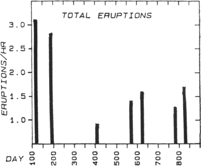
"The frequency of eruptions varies widely with time. We have found no clear-cut cyclicity nor other obvious patterns in these data (figure 22). Over the past 2 years, the seven periods of close monitoring suggest a decline in the frequency of pyroclastic eruptions followed by a slight increase. During the April 1989 observations, the number of explosions (type 1) particularly increased. Small lava flows moving down the S slope also led to an increase in recorded rockslides. However, during the past 2 years, most of the lava flows have moved down the N slopes, many of them in the headwaters of the Río Tabacón; rockslides associated with their advance are not audible from the Observatory.
 |
Figure 22. Average number of eruptions at Arenal per hour during each 10-14-day period of observation, 28 April 1987-April 1989. |
"The number of pyroclastic events decreased dramatically after about 15 April 1989, reaching the lowest level in the past 2 years. Only one explosion occurred during 5 days of close monitoring 30 June-4 July. During that time, intense lava fountaining in the summit crater was visible at night and at least two wide but thin flows were active on the N flank, in the headwaters of the Río Tabacón, with advancing flow fronts ~1,200 m below the new crater, now at ~1,600 m elevation. This is the second period of low pyroclastic activity associated with a high level of lava flow production. The first was recorded 9-19 February 1988, when an active lava flow had reached ~1,200 m elevation in the headwaters of the Río Tabacón. The rate of magma emission is far greater during times of strong lava emission than during even high levels of pyroclastic activity. It is likely that during periods of high rates of lava production, the conduit is essentially open, preventing formation of a plug by cooling and degassing, and hence the buildup of vapor pressure and attendant pyroclastic events.
"We find no consistent relationship between tremor levels and eruption frequency or type during our last two periods of close monitoring, except for Type 2 eruptions, which were most common at high tremor levels during both periods. Notably, explosions (Type 1 eruptions) occurred at minimal levels during tremor-free periods during the February expedition, but at maximum frequency during periods of maximum tremor in February."
The ICE reported that seismicity declined to a moderate level in June, with a mean of only three recorded volcanic earthquakes/day. However, there was an increase in the number of harmonic tremor episodes, related to lava degassing.
Further Reference. Melson, W., 1989, Las erupciones del Volcán Arenal, 1 al 13 de Abril de 1989: Boletín de Vulcanología (Univ Nacional, Costa Rica), no. 20, p. 15-22 (in Spanish).
Geological Summary. Conical Volcán Arenal is the youngest stratovolcano in Costa Rica and one of its most active. The 1670-m-high andesitic volcano towers above the eastern shores of Lake Arenal, which has been enlarged by a hydroelectric project. Arenal lies along a volcanic chain that has migrated to the NW from the late-Pleistocene Los Perdidos lava domes through the Pleistocene-to-Holocene Chato volcano, which contains a 500-m-wide, lake-filled summit crater. The earliest known eruptions of Arenal took place about 7000 years ago, and it was active concurrently with Cerro Chato until the activity of Chato ended about 3500 years ago. Growth of Arenal has been characterized by periodic major explosive eruptions at several-hundred-year intervals and periods of lava effusion that armor the cone. An eruptive period that began with a major explosive eruption in 1968 ended in December 2010; continuous explosive activity accompanied by slow lava effusion and the occasional emission of pyroclastic flows characterized the eruption from vents at the summit and on the upper western flank.
Information Contacts: W. Melson, SI; V. Barboza, J. Barquero, E. Fernández, and R. Saenz, OVSICORI; R. Barquero and G. Alvarado, ICE.


