Report on Raung (Indonesia) — 25 July-31 July 2007
Smithsonian Institution / US Geological Survey
Weekly Volcanic Activity Report, 25 July-31 July 2007
Managing Editor: Sally Sennert.
Please cite this report as:
Global Volcanism Program, 2007. Report on Raung (Indonesia) (Sennert, S, ed.). Weekly Volcanic Activity Report, 25 July-31 July 2007. Smithsonian Institution and US Geological Survey.
Raung
Indonesia
8.119°S, 114.056°E; summit elev. 3260 m
All times are local (unless otherwise noted)
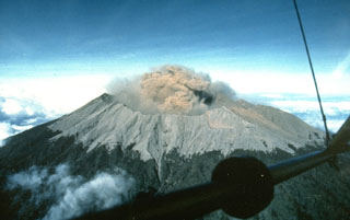
Based on a pilot report, the Darwin VAAC reported that an ash plume possibly from Raung rose to an altitude of 1.5 km (5,000 ft) a.s.l. Ash was not visible on satellite imagery.
Geological Summary. Raung, one of Java's most active volcanoes, is a massive stratovolcano in easternmost Java that was constructed SW of the rim of Ijen caldera. The unvegetated summit is truncated by a dramatic steep-walled, 2-km-wide caldera that has been the site of frequent historical eruptions. A prehistoric collapse of Gunung Gadung on the W flank produced a large debris avalanche that traveled 79 km, reaching nearly to the Indian Ocean. Raung contains several centers constructed along a NE-SW line, with Gunung Suket and Gunung Gadung stratovolcanoes being located to the NE and W, respectively.

