Report on Karangetang (Indonesia) — 15 August-21 August 2007
Smithsonian Institution / US Geological Survey
Weekly Volcanic Activity Report, 15 August-21 August 2007
Managing Editor: Sally Sennert.
Please cite this report as:
Global Volcanism Program, 2007. Report on Karangetang (Indonesia) (Sennert, S, ed.). Weekly Volcanic Activity Report, 15 August-21 August 2007. Smithsonian Institution and US Geological Survey.
Karangetang
Indonesia
2.781°N, 125.407°E; summit elev. 1797 m
All times are local (unless otherwise noted)
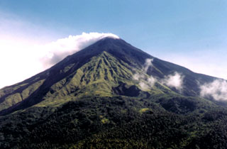
The Alert Status of Karangetang was raised on 18 August from 3 to 4 (on a scale of 1-4) due to increased eruptive activity, based on visual observation and increased seismicity. According to news articles, lava flowed about 1 km down the S slope and "booming" noises were heard. Thick ashfall covered villages, farms, and trees on the slopes.
Geological Summary. Karangetang (Api Siau) volcano lies at the northern end of the island of Siau, about 125 km NNE of the NE-most point of Sulawesi. The stratovolcano contains five summit craters along a N-S line. It is one of Indonesia's most active volcanoes, with more than 40 eruptions recorded since 1675 and many additional small eruptions that were not documented (Neumann van Padang, 1951). Twentieth-century eruptions have included frequent explosive activity sometimes accompanied by pyroclastic flows and lahars. Lava dome growth has occurred in the summit craters; collapse of lava flow fronts have produced pyroclastic flows.
Sources: The Jakarta Post, Reuters, Agence France-Presse (AFP), Pusat Vulkanologi dan Mitigasi Bencana Geologi (PVMBG, also known as CVGHM)

