Report on Balbi (Papua New Guinea) — 30 April-6 May 2008
Smithsonian Institution / US Geological Survey
Weekly Volcanic Activity Report, 30 April-6 May 2008
Managing Editor: Sally Sennert.
Please cite this report as:
Global Volcanism Program, 2008. Report on Balbi (Papua New Guinea) (Sennert, S, ed.). Weekly Volcanic Activity Report, 30 April-6 May 2008. Smithsonian Institution and US Geological Survey.
Balbi
Papua New Guinea
5.9156°S, 155.0008°E; summit elev. 2715 m
All times are local (unless otherwise noted)
Based on information from RVO, the Darwin VAAC reported that Balbi erupted on 7 May. Ash was not detected on satellite imagery. [Correction: RVO later confirmed that Balbi did not erupt on 7 May and attributed the reports to thunderstorm activity.]
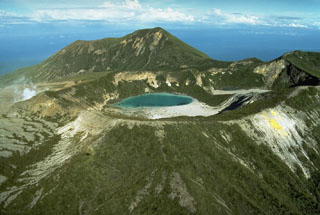
Geological Summary. The complex andesitic Balbi stratovolcano on Bougainville Island includes a large number of coalesced cones and lava domes. Five well-preserved craters occupy a NW-SE-trending ridge north of the summit cone, which also contains a crater. Three large valleys with steep headwalls dissect the flanks. The age of the most recent eruption is not known precisely. An oral tradition of a major eruption during the 19th century is thought to be in error, but could refer to minor eruptive activity. Fumaroles are located within 600-m-wide Crater B and on its W flank.

