Report on Kasatochi (United States) — 6 August-12 August 2008
Smithsonian Institution / US Geological Survey
Weekly Volcanic Activity Report, 6 August-12 August 2008
Managing Editor: Sally Sennert.
Please cite this report as:
Global Volcanism Program, 2008. Report on Kasatochi (United States) (Sennert, S, ed.). Weekly Volcanic Activity Report, 6 August-12 August 2008. Smithsonian Institution and US Geological Survey.
Kasatochi
United States
52.177°N, 175.508°W; summit elev. 314 m
All times are local (unless otherwise noted)
On 6 August, AVO raised the Volcano Alert Level for Kasatochi to Advisory and the Aviation Color Code to Yellow based on increased seismicity detected that day by instruments in the area and by field crews on the island the previous few days. Kasatochi lacks dedicated seismometers and is monitored by neighboring networks.
On 7 August, earthquake activity continued; events as large as M 5.6 were detected. Crews reported rockfalls, ground shaking lasting 5-10 minutes, and a strong sulfur smell. Periods of volcanic tremor prompted AVO to raise the Volcano Alert Level to Watch and the Aviation Color Code to Orange. Later that day, an ash plume at an altitude of at least 10.7 km (35,000 ft) a.s.l. was detected on satellite imagery drifting SSW. The Volcano Alert Level was raised to Warning and the Aviation Color Code was raised to Red. Reports from a marine vessel in the area indicated ashfall and tephra up to pebble size, spectacular lightning, and total darkness for a little over 2 hours. Three major explosive eruptions produced ash plumes that rose to an altitude of 13.7 km (45,000 ft) a.s.l.
Ash emissions became continuous on 8 August following the last explosive event; an ash plume drifted for more than 950 km in a counterclockwise spiral at altitudes of about 9.1-13.7 km (30,000-45,000 ft) a.s.l. Seismicity decreased, although remained elevated, and ash emissions became less frequent. During 8-9 August, seismicity decreased to a level undetectable by stations on Great Sitkin, about 40 km W. On 9 August ash plumes were detected on satellite imagery early in the day; clouds prevented views during the rest of the day. The Volcano Alert Level was lowered to Watch and the Aviation Color Code to Orange. The ash plume from the third eruption on 7 August was seen on satellite imagery 1,850 km ESE of the volcano and was elongated NE-SW over 1,200 km.
According to news articles, flights from Alaska to several west coast cities were cancelled on 10 and 11 August. During 10-12 August, AVO reported that seismicity remained low, but detectable by the network on Great Sitkin.
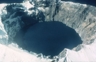
Geological Summary. Located at the northern end of a shallow submarine ridge trending perpendicular to the Aleutian arc, Kasatochi is small 2.7 x 3.3 km island volcano with a 750-m-wide summit crater lake. The summit reaches only about 300 m elevation, and the lake surface lies less than about 60 m above the sea. A lava dome is located on the NW flank at about 150 m elevation. The asymmetrical island is steeper on the northern side than the southern, and the crater lies north of the center of the island. Reports of activity from the heavily eroded Koniuji volcano to the east probably refer to eruptions from Kasatochi. A lava flow may have been emplaced during the first recorded eruption in 1760. A major explosive eruption in 2008 produced pyroclastic flows and surges that swept into the sea, extending the island's shoreline.
Sources: US Geological Survey Alaska Volcano Observatory (AVO), The Seattle Times Company

