Report on Krakatau (Indonesia) — 1 April-7 April 2009
Smithsonian Institution / US Geological Survey
Weekly Volcanic Activity Report, 1 April-7 April 2009
Managing Editor: Sally Sennert.
Please cite this report as:
Global Volcanism Program, 2009. Report on Krakatau (Indonesia) (Sennert, S, ed.). Weekly Volcanic Activity Report, 1 April-7 April 2009. Smithsonian Institution and US Geological Survey.
Krakatau
Indonesia
6.1009°S, 105.4233°E; summit elev. 285 m
All times are local (unless otherwise noted)
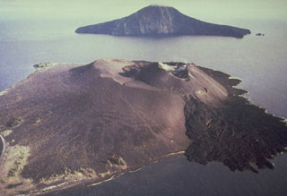
During 27-30 March and 1 April, CVGHM reported that visual observations of Krakatau when the weather was clear revealed that ash plumes rose 200-800 m above the Anak Krakatau crater. On 2 April, an ash eruption was seen on satellite imagery and reported by a pilot. A resultant ash plume drifted more than 60 km S. The Alert Level remained at 2 (on a scale of 1-4).
Geological Summary. The renowned Krakatau (frequently mis-named as Krakatoa) volcano lies in the Sunda Strait between Java and Sumatra. Collapse of an older edifice, perhaps in 416 or 535 CE, formed a 7-km-wide caldera. Remnants of that volcano are preserved in Verlaten and Lang Islands; subsequently the Rakata, Danan, and Perbuwatan cones were formed, coalescing to create the pre-1883 Krakatau Island. Caldera collapse during the catastrophic 1883 eruption destroyed Danan and Perbuwatan, and left only a remnant of Rakata. This eruption caused more than 36,000 fatalities, most as a result of tsunamis that swept the adjacent coastlines of Sumatra and Java. Pyroclastic surges traveled 40 km across the Sunda Strait and reached the Sumatra coast. After a quiescence of less than a half century, the post-collapse cone of Anak Krakatau (Child of Krakatau) was constructed within the 1883 caldera at a point between the former Danan and Perbuwatan cones. Anak Krakatau has been the site of frequent eruptions since 1927.
Source: Pusat Vulkanologi dan Mitigasi Bencana Geologi (PVMBG, also known as CVGHM)

