Report on Fernandina (Ecuador) — 15 April-21 April 2009
Smithsonian Institution / US Geological Survey
Weekly Volcanic Activity Report, 15 April-21 April 2009
Managing Editor: Sally Sennert.
Please cite this report as:
Global Volcanism Program, 2009. Report on Fernandina (Ecuador) (Sennert, S, ed.). Weekly Volcanic Activity Report, 15 April-21 April 2009. Smithsonian Institution and US Geological Survey.
Fernandina
Ecuador
0.37°S, 91.55°W; summit elev. 1476 m
All times are local (unless otherwise noted)
Based on analysis of satellite imagery and information from IG, the Washington VVAC reported that during 15-16 April gas-and-steam plumes from Fernandina drifted up to 555 km W and a thermal anomaly was detected on the W half of the island. According to news articles, the eruption caused the deaths of numerous fish and multiple sea lions that were found floating in the sea.
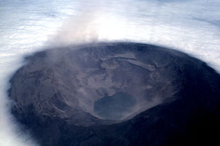
Geological Summary. Fernandina, the most active of Galápagos volcanoes and the one closest to the Galápagos mantle plume, is a basaltic shield volcano with a deep 5 x 6.5 km summit caldera. The volcano displays the classic "overturned soup bowl" profile of Galápagos shield volcanoes. Its caldera is elongated in a NW-SE direction and formed during several episodes of collapse. Circumferential fissures surround the caldera and were instrumental in growth of the volcano. Reporting has been poor in this uninhabited western end of the archipelago, and even a 1981 eruption was not witnessed at the time. In 1968 the caldera floor dropped 350 m following a major explosive eruption. Subsequent eruptions, mostly from vents located on or near the caldera boundary faults, have produced lava flows inside the caldera as well as those in 1995 that reached the coast from a SW-flank vent. Collapse of a nearly 1 km3 section of the east caldera wall during an eruption in 1988 produced a debris-avalanche deposit that covered much of the caldera floor and absorbed the caldera lake.
Sources: Agence France-Presse (AFP), Washington Volcanic Ash Advisory Center (VAAC)

