Report on Fukutoku-Oka-no-Ba (Japan) — 3 February-9 February 2010
Smithsonian Institution / US Geological Survey
Weekly Volcanic Activity Report, 3 February-9 February 2010
Managing Editor: Sally Sennert.
Please cite this report as:
Global Volcanism Program, 2010. Report on Fukutoku-Oka-no-Ba (Japan) (Sennert, S, ed.). Weekly Volcanic Activity Report, 3 February-9 February 2010. Smithsonian Institution and US Geological Survey.
Fukutoku-Oka-no-Ba
Japan
24.285°N, 141.481°E; summit elev. -29 m
All times are local (unless otherwise noted)
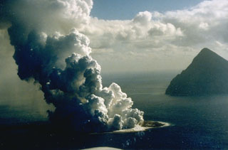
According to news articles, JMA reported Surtseyan explosions from Fukutoku-Okanoba, 5 km NE of the island of Minami-Iwo-jima, on 3 February. Steam-and-ash plumes rose 100 m a.s.l. and the surrounding sea turned yellow-green. Video footage of the event was captured by people aboard a Japanese Coast Guard patrol boat. One article stated that the sea in the area had regularly changed colors since the 1950s, most recently in December 2009.
Geological Summary. Fukutoku-Oka-no-ba is a submarine volcano located 5 km NE of the island of Minami-Ioto. Water discoloration is frequently observed, and several ephemeral islands have formed in the 20th century. The first of these formed Shin-Ioto ("New Sulfur Island") in 1904, and the most recent island was formed in 1986. The volcano is part of an elongated edifice with two major topographic highs trending NNW-SSE, and is a trachyandesitic volcano geochemically similar to Ioto.
Sources: ITN News, The Mainichi Daily News

