Report on Grimsvotn (Iceland) — 25 May-31 May 2011
Smithsonian Institution / US Geological Survey
Weekly Volcanic Activity Report, 25 May-31 May 2011
Managing Editor: Sally Sennert.
Please cite this report as:
Global Volcanism Program, 2011. Report on Grimsvotn (Iceland) (Sennert, S, ed.). Weekly Volcanic Activity Report, 25 May-31 May 2011. Smithsonian Institution and US Geological Survey.
Grimsvotn
Iceland
64.416°N, 17.316°W; summit elev. 1719 m
All times are local (unless otherwise noted)
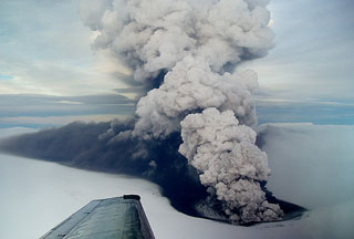
According to scientists from the Institute of Earth Sciences at the University of Iceland and the Icelandic Meteorological Office, explosive activity occurred from four tephra cones surrounded by water in Grímsvötn's crater during the evening of 24 May. Pulsating ash plumes rose a few kilometers above the cones, producing only local fallout of material. Seismic tremor decreased. On 25 May, observers noted steam bursts from the crater. Tephra fallout was noted only in the vicinity of the eruption site. Pilots reported widespread ash in layers 5-7 km W of the volcano and also some ash haze below 3 km (9,800 ft) a.s.l. to the SW. Seismic tremor decreased considerably. On 26 May minor steam explosions continued from the crater. According to news articles, air traffic disruption was reduced to parts of Norway and Sweden. On 28 May tremor rapidly decreased then disappeared, and on 30 May participants on the Iceland Glaciological Society's spring expedition confirmed that the eruption had ended. Satellite imagery and visual observations showed that only small amounts of ice melted during the eruption; no signs of flooding had been detected.
Geological Summary. Grímsvötn, Iceland's most frequently active volcano in recent history, lies largely beneath the vast Vatnajökull icecap. The caldera lake is covered by a 200-m-thick ice shelf, and only the southern rim of the 6 x 8 km caldera is exposed. The geothermal area in the caldera causes frequent jökulhlaups (glacier outburst floods) when melting raises the water level high enough to lift its ice dam. Long NE-SW-trending fissure systems extend from the central volcano. The most prominent of these is the noted Laki (Skaftar) fissure, which extends to the SW and produced the world's largest known historical lava flow in 1783. The 15 km3 basaltic Laki lavas were erupted over 7 months from a 27-km-long fissure system. Extensive crop damage and livestock losses caused a severe famine that resulted in the loss of one-fifth of the population of Iceland.
Sources: Institute of Earth Sciences, Agence France-Presse (AFP), Icelandic Meteorological Office (IMO)

