Report on Galeras (Colombia) — 17 October-23 October 2012
Smithsonian Institution / US Geological Survey
Weekly Volcanic Activity Report, 17 October-23 October 2012
Managing Editor: Sally Sennert.
Please cite this report as:
Global Volcanism Program, 2012. Report on Galeras (Colombia) (Sennert, S, ed.). Weekly Volcanic Activity Report, 17 October-23 October 2012. Smithsonian Institution and US Geological Survey.
Galeras
Colombia
1.22°N, 77.37°W; summit elev. 4276 m
All times are local (unless otherwise noted)
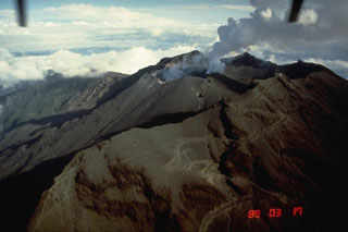
INGEOMINAS reported that during 17-23 October cameras around Galeras recorded daily emissions. On 19 and 21 October the plumes contained ash and rose 1.8 km above the crater. On 19 October observatory staff reported fine ashfall on the NE flank and a sulfur odor was reported in Consacá Sandoná (W flank). Staff at the Galeras National Park Wildlife Sanctuary reported sulfur odors on the E side of the volcano. The Alert Level remained at III (Yellow; "changes in the behavior of volcanic activity").
Geological Summary. Galeras, a stratovolcano with a large breached caldera located immediately west of the city of Pasto, is one of Colombia's most frequently active volcanoes. The dominantly andesitic complex has been active for more than 1 million years, and two major caldera collapse eruptions took place during the late Pleistocene. Long-term extensive hydrothermal alteration has contributed to large-scale edifice collapse on at least three occasions, producing debris avalanches that swept to the west and left a large open caldera inside which the modern cone has been constructed. Major explosive eruptions since the mid-Holocene have produced widespread tephra deposits and pyroclastic flows that swept all but the southern flanks. A central cone slightly lower than the caldera rim has been the site of numerous small-to-moderate eruptions since the time of the Spanish conquistadors.

