Report on Copahue (Chile-Argentina) — 9 January-15 January 2013
Smithsonian Institution / US Geological Survey
Weekly Volcanic Activity Report, 9 January-15 January 2013
Managing Editor: Sally Sennert.
Please cite this report as:
Global Volcanism Program, 2013. Report on Copahue (Chile-Argentina) (Sennert, S, ed.). Weekly Volcanic Activity Report, 9 January-15 January 2013. Smithsonian Institution and US Geological Survey.
Copahue
Chile-Argentina
37.856°S, 71.183°W; summit elev. 2953 m
All times are local (unless otherwise noted)
OVDAS-SERNAGEOMIN reported that the web camera near Copahue recorded white gas plumes rising 0.9-1.5 km above the crater during 9-15 January and drifting NNE, E, ESE, and SSE. Incandescence from the crater was observed on some nights. Satellite images showed plumes drifting 10 km E and SSE during 10-12 January. The Alert Level remained at Orange.
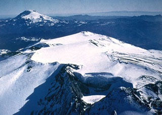
Geological Summary. Volcán Copahue is an elongated composite cone constructed along the Chile-Argentina border within the 6.5 x 8.5 km wide Trapa-Trapa caldera that formed between 0.6 and 0.4 million years ago near the NW margin of the 20 x 15 km Pliocene Caviahue (Del Agrio) caldera. The eastern summit crater, part of a 2-km-long, ENE-WSW line of nine craters, contains a briny, acidic 300-m-wide crater lake (also referred to as El Agrio or Del Agrio) and displays intense fumarolic activity. Acidic hot springs occur below the eastern outlet of the crater lake, contributing to the acidity of the Río Agrio, and another geothermal zone is located within Caviahue caldera about 7 km NE of the summit. Infrequent mild-to-moderate explosive eruptions have been recorded since the 18th century. Twentieth-century eruptions from the crater lake have ejected pyroclastic rocks and chilled liquid sulfur fragments.
Source: Servicio Nacional de Geología y Minería (SERNAGEOMIN)

