Report on Veniaminof (United States) — 5 June-11 June 2013
Smithsonian Institution / US Geological Survey
Weekly Volcanic Activity Report, 5 June-11 June 2013
Managing Editor: Sally Sennert.
Please cite this report as:
Global Volcanism Program, 2013. Report on Veniaminof (United States) (Sennert, S, ed.). Weekly Volcanic Activity Report, 5 June-11 June 2013. Smithsonian Institution and US Geological Survey.
Veniaminof
United States
56.17°N, 159.38°W; summit elev. 2507 m
All times are local (unless otherwise noted)
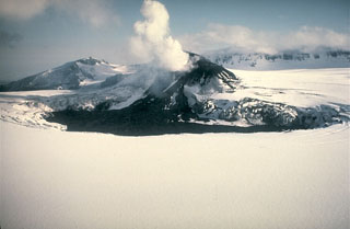
On 8 June AVO reported that gradually increasing seismic tremor at Veniaminof had been detected during the previous two days. The Aviation Color Code was raised to Yellow and the Volcano Alert Level was raised to Advisory. Clear web-camera and satellite views showed nothing unusual at the volcano. During 8-10 June seismicity continued to increase and a persistent steam plume rose from the central cone within the caldera.
Geological Summary. Veniaminof, on the Alaska Peninsula, is truncated by a steep-walled, 8 x 11 km, glacier-filled caldera that formed around 3,700 years ago. The caldera rim is up to 520 m high on the north, is deeply notched on the west by Cone Glacier, and is covered by an ice sheet on the south. Post-caldera vents are located along a NW-SE zone bisecting the caldera that extends 55 km from near the Bering Sea coast, across the caldera, and down the Pacific flank. Historical eruptions probably all originated from the westernmost and most prominent of two intra-caldera cones, which rises about 300 m above the surrounding icefield. The other cone is larger, and has a summit crater or caldera that may reach 2.5 km in diameter, but is more subdued and barely rises above the glacier surface.
Source: US Geological Survey Alaska Volcano Observatory (AVO)

