Report on Paluweh (Indonesia) — 2 April-8 April 2014
Smithsonian Institution / US Geological Survey
Weekly Volcanic Activity Report, 2 April-8 April 2014
Managing Editor: Sally Sennert.
Please cite this report as:
Global Volcanism Program, 2014. Report on Paluweh (Indonesia) (Sennert, S, ed.). Weekly Volcanic Activity Report, 2 April-8 April 2014. Smithsonian Institution and US Geological Survey.
Paluweh
Indonesia
8.32°S, 121.708°E; summit elev. 875 m
All times are local (unless otherwise noted)
PVMBG reported that observers at a post located in Kampung Ropa, Keliwumbu Village, noted that during January-5 April activity at Paluweh mainly consisted of white and gray fumarolic plumes rising at most 100 m above the lava dome and drifting W, N, and E. The report stated that the lava dome had not changed between September 2013 and March 2014 observations. Seismicity had decreased in November 2013 and remained low; the number of avalanches had also decreased. On 7 April the Alert Level was lowered to 2 (on a scale of 1-4).
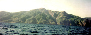
Geological Summary. Paluweh volcano, also known as Rokatenda, forms the 8-km-wide island of Palu'e north of the volcanic arc that cuts across Flores Island. The broad irregular summit region contains overlapping craters up to 900 m wide and several lava domes. Several flank vents occur along a NW-trending fissure. The largest historical eruption occurred in 1928, when strong explosive activity was accompanied by landslide-induced tsunamis and lava dome emplacement. Pyroclastic flows in August 2013 resulted in fatalities.
Source: Pusat Vulkanologi dan Mitigasi Bencana Geologi (PVMBG, also known as CVGHM)

