Report on Sinabung (Indonesia) — 29 October-4 November 2014
Smithsonian Institution / US Geological Survey
Weekly Volcanic Activity Report, 29 October-4 November 2014
Managing Editor: Sally Sennert.
Please cite this report as:
Global Volcanism Program, 2014. Report on Sinabung (Indonesia) (Sennert, S, ed.). Weekly Volcanic Activity Report, 29 October-4 November 2014. Smithsonian Institution and US Geological Survey.
Sinabung
Indonesia
3.17°N, 98.392°E; summit elev. 2460 m
All times are local (unless otherwise noted)
Based on a pilot observation, the Darwin VAAC reported localized ash from Sinabung on 2 November, but a meteorological cloud in the area prevented further observations. A pyroclastic flow and an ash plume were recorded by the webcam on 3 November. The ash plume rose to an estimated altitude of 4.6 km (15,000 ft) a.s.l. and drifted NE; the altitude of the ash plume was again uncertain due to meteorological cloud. On 4 November an ash plume observed with the webcam rose to an altitude of 4.3 km (14,000 ft) a.s.l. and drifted N.
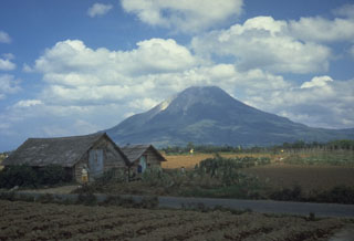
Geological Summary. Gunung Sinabung is a Pleistocene-to-Holocene stratovolcano with many lava flows on its flanks. The migration of summit vents along a N-S line gives the summit crater complex an elongated form. The youngest crater of this conical andesitic-to-dacitic edifice is at the southern end of the four overlapping summit craters. The youngest deposit is a SE-flank pyroclastic flow 14C dated by Hendrasto et al. (2012) at 740-880 CE. An unconfirmed eruption was noted in 1881, and solfataric activity was seen at the summit and upper flanks in 1912. No confirmed historical eruptions were recorded prior to explosive eruptions during August-September 2010 that produced ash plumes to 5 km above the summit.

