Report on Turrialba (Costa Rica) — 29 October-4 November 2014
Smithsonian Institution / US Geological Survey
Weekly Volcanic Activity Report, 29 October-4 November 2014
Managing Editor: Sally Sennert.
Please cite this report as:
Global Volcanism Program, 2014. Report on Turrialba (Costa Rica) (Sennert, S, ed.). Weekly Volcanic Activity Report, 29 October-4 November 2014. Smithsonian Institution and US Geological Survey.
Turrialba
Costa Rica
10.025°N, 83.767°W; summit elev. 3340 m
All times are local (unless otherwise noted)
OVSICORI-UNA reported that seismic activity at Turrialba had started to increase in late September, and then in mid-October a three-day swarm of volcano-tectonic earthquakes was recorded. The largest event, a M 2.8, occurred at 2035 on 16 October at a depth of 5 km beneath the active crater. Magmatic degassing intensified during 28-29 October; sulfur dioxide flux was 2,000 tons per day, higher than the 1,300 tons per day average measured in September and the highest so far during 2014. During the morning of 29 October a seismologist noted a tremor signal which increased in amplitude during the afternoon and evening. An observer at a lodge noted that the gas plume was darker than usual with some ash. At 2310 a small phreatomagmatic eruption from the West Crater lasted about 25 minutes and ended with a strong explosion heard by nearby villagers. An ash cloud rose to an altitude of 5.8 km (19,000 ft) a.s.l. and drifted WSW. Ash fell in San Gerardo de Irazú, San Ramón de Tres Ríos, Coronado, Moravia, Curridabat, Desamparados, Aserrí, Escazú, Santa Ana, Belén, Guácima de Alajuela, Río Segundo de Alajuela, San Pedro Montes de Oca, Guadalupe, areas of Heredia, and the capital of San José (70 km W). The eruption destroyed the wall between the West and Central craters, depositing material around the Central Crater and partially burying it. According to a news report 11 people from Santa Cruz de Turrialba were evacuated to shelters and the national park was closed. Some schools were also temporarily closed, affecting over 300 area students.
The eruption continued during 30-31 October; analyses of collected tephra showed that the proportion of juvenile material increased its volume from 3-5% on 30 October to 7-10% the next day. Magma had not previously reached the surface at Turrialba since an eruption in 1866.
An explosion at 0520 on 1 November generated an ash plume that drifted towards the E and N parts of the Central Valley. A 3 November report stated that during the previous 24 hours seismicity had decreased significantly and no explosions were detected; seismicity remained elevated as compared to levels detected prior to the current activity. An online tool that allowed residents to note if they had observed ashfall during 31 October-4 November showed a dispersion pattern in the Central Valley W and NW of Turrialba.
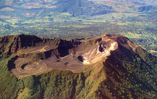
Geological Summary. Turrialba, the easternmost of Costa Rica's Holocene volcanoes, is a large vegetated basaltic-to-dacitic stratovolcano located across a broad saddle NE of Irazú volcano overlooking the city of Cartago. The massive edifice covers an area of 500 km2. Three well-defined craters occur at the upper SW end of a broad 800 x 2200 m summit depression that is breached to the NE. Most activity originated from the summit vent complex, but two pyroclastic cones are located on the SW flank. Five major explosive eruptions have occurred during the past 3500 years. A series of explosive eruptions during the 19th century were sometimes accompanied by pyroclastic flows. Fumarolic activity continues at the central and SW summit craters.
Sources: Observatorio Vulcanologico y Sismologico de Costa Rica-Universidad Nacional (OVSICORI-UNA), Agence France-Presse (AFP), La Nacion, Washington Volcanic Ash Advisory Center (VAAC)

